Related Research Articles

Tulagi, less commonly known as Tulaghi, is a small island—5.5 by 1 kilometre, area 2.08 square kilometres (0.80 sq mi)—in Solomon Islands, just off the south coast of Ngella Sule. The town of the same name on the island was the capital of the British Solomon Islands Protectorate from 1896 to 1942 and is today the capital of the Central Province. The capital of what is now the state of Solomon Islands moved to Honiara, Guadalcanal, after World War II.
Savo Island is an island in Solomon Islands in the South Pacific ocean. Administratively, Savo Island is a part of the Central Province of Solomon Islands. It is about 35 kilometres (22 mi) from the national capital of Honiara. The principal village is Alialia, in the north of the island.
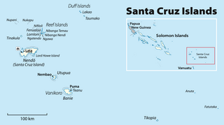
The Duff Islands are a small island group lying to the northeast of the Santa Cruz Islands in the Solomon Islands province of Temotu. They are also sometimes known as the Wilson Islands.

The Nggela Islands, also known as the Florida Islands, are a small island group in the Central Province of Solomon Islands, a sovereign state in the southwest Pacific Ocean.

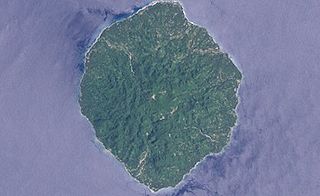
The island of Makira is the largest island of Makira-Ulawa Province in Solomon Islands. It is third most populous of the Solomon Islands after Malaita and Guadalcanal, with a population of 55,126 as of 2020. The island is located east of Guadalcanal and south of Malaita. The largest and capital city is Kirakira.

Namu Atoll is a coral atoll of 54 islands in the Pacific Ocean, and forms a legislative district of the Ralik Chain of the Marshall Islands. Its total land area is only 6.27 square kilometers (2.42 sq mi), but that encloses a lagoon of 397 square kilometers (153 sq mi). It is located approximately 62 kilometers (39 mi) south-southwest of Kwajalein Atoll.
Gavutu is a small islet in the Central Province of Solomon Islands, some 500 metres in length. It is one of the Nggela Islands.

Roncador Reef is a reef in Solomon Islands, south of Ontong Java Atoll and north of Santa Isabel Island.

Choiseul Island, native name Lauru, is the largest island of the Choiseul Province, Solomon Islands, at 7.08°S 157°E. The administrative headquarters of Choiseul Province is situated in the town of Taro, on Taro Island.
San Jorge Island is the second largest island in the Isabel Province, Solomon Islands.
Ulawa Island is an island in Solomon Islands. It is located near Malaita Island and belongs to Makira Ulawa Province. The island has an area of 65.92 square kilometres.
Tanambogo is an islet in the Central Province of Solomon Islands. It is one of the Florida Islands.
Ali'ite is an island in Solomon Islands; it is the northern one of the Olu Malau Islands located in Makira-Ulawa Province. It has an area of 2.91 km2.
Malaulalo is an uninhabited island in Solomon Islands; it is the central one of the Olu Malau Islands located in Makira-Ulawa Province. It has an area of 3.34 km2.
Malaupaina is an island in the nation state of Solomon Islands; it is the southern one of the Olu Malau Islands located in Makira-Ulawa Province. It has an area of 6.37 km2.

Owaraha or Owa Raha is an island in Makira-Ulawa Province, Solomon Islands.

Owariki or Owa rigi is an island in Solomon Islands; it is located in Makira-Ulawa Province.

The Ninigo Islands are a group of 31 islands within the Western Islands of the Bismarck Archipelago, Papua New Guinea. Their coordinates are 1°16′S144°15′E.
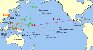
Álvaro de Saavedra, fully Álvaro de Saavedra Cerón, was one of the Spanish explorers of the Pacific Ocean.

Laberintos de pasión is a Mexican telenovela produced by Ernesto Alonso for Televisa in 1999-2000. It aired on Canal de Las Estrellas from October 4, 1999 to January 21, 2000, weekdays at 8:00pm.
References
- ↑ Sharp, Andrew The discovery of the Pacific Islands Oxford 1960 p.44,45.
- ↑ Brand, Donald D. The Pacific Basin A History of its Geographical Explorations The American Geographical Society, New York, 1967, p.133.
- ↑ Zaragoza, Justo "Relación de Hernán Gallego" in Historia del descubrimiento de las regiones australes hecho por el general Pedro Fernández de Quirós, Madrid, 1876, t.I, p.3.
8°15′S160°11′E / 8.250°S 160.183°E
| | This Solomon Islands location article is a stub. You can help Wikipedia by expanding it. |