
The Guadalcanal campaign, also known as the Battle of Guadalcanal and codenamed Operation Watchtower by American forces, was a military campaign fought between 7 August 1942 and 9 February 1943 on and around the island of Guadalcanal in the Pacific theater of World War II. It was the first major land offensive by Allied forces against the Empire of Japan.

Tulagi, less commonly known as Tulaghi, is a small island in Solomon Islands, just off the south coast of Ngella Sule. The town of the same name on the island was the capital of the British Solomon Islands Protectorate from 1896 to 1942 and is today the capital of the Central Province. The capital of what is now the state of Solomon Islands moved to Honiara, Guadalcanal, after World War II.
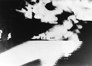
The Battle of Savo Island, also known as the First Battle of Savo Island and in Japanese sources as the First Battle of the Solomon Sea, and colloquially among Allied Guadalcanal veterans as the Battle of the Five Sitting Ducks, was a naval battle of the Solomon Islands campaign of the Pacific War of World War II between the Imperial Japanese Navy and Allied naval forces. The battle took place on 8–9 August 1942 and was the first major naval engagement of the Guadalcanal campaign and the first of several naval battles in the straits later named Ironbottom Sound, near the island of Guadalcanal.
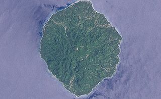
Savo Island is an island in Solomon Islands in the South Pacific ocean. Administratively, Savo Island is a part of the Central Province of Solomon Islands. It is about 35 kilometres (22 mi) from the national capital of Honiara. The principal village is Alialia, in the north of the island.

USS Aaron Ward (DD-483) was a Gleaves-class destroyer in the service of the United States Navy. She was the second Navy ship named in honor of Rear Admiral Aaron Ward. She sank on 7 April 1943 in a shoal near Tinete Point of Nggela Sule, Solomon Islands during Operation I-Go. Her wreck was discovered on 4 September 1994.
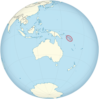
Solomon Islands is divided into nine provinces. The national capital, Honiara, on the island of Guadalcanal, is separately governed as the country's Capital Territory.

The Central Province is one of the provinces of Solomon Islands, covering the Russell Islands, Nggela Islands and Savo Island. Its area comprises 615 square kilometres and had a population of 26,051 as of 2009, rising to 30,326 as of 2019. The provincial capital is Tulagi.

Purvis Bay is located in the Nggela Islands, part of the Solomon Islands. Purvis Bay is the sheltered area to the south of the island Nggela Sule, including and trending southeast from the neighbouring Tulagi islet.
Gavutu is a small islet in the Central Province of Solomon Islands, some 500 metres in length. It is one of the Nggela Islands.

The Solomon Islands campaign was a major campaign of the Pacific War of World War II. The campaign began with Japanese landings and capture of several areas in the British Solomon Islands and Bougainville, in the Territory of New Guinea, during the first six months of 1942. The Japanese occupied these locations and began the construction of several naval and air bases with the goals of protecting the flank of the Japanese offensive in New Guinea, establishing a security barrier for the major Japanese base at Rabaul on New Britain, and providing bases for interdicting supply lines between the Allied powers of the United States and Australia and New Zealand.

Henderson Field is a former military airfield on Guadalcanal, Solomon Islands, during World War II. Originally built by the Japanese Empire, the conflict over its possession was one of the great battles of the Pacific War. Today it is Honiara International Airport.
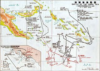
Operation Mo or the Port Moresby Operation was a Japanese plan to take control of the Australian Territory of New Guinea during World War II as well as other locations in the South Pacific. The goal was to isolate Australia and New Zealand from the Allied United States.
The invasion of Tulagi, on 3–4 May 1942, was part of Operation Mo, the Empire of Japan's strategy in the South Pacific and South West Pacific Area in 1942. The plan called for Imperial Japanese Navy troops to capture Tulagi and nearby islands in the British Solomon Islands Protectorate. The occupation of Tulagi by the Japanese was intended to cover the flank of and provide reconnaissance support for Japanese forces that were advancing on Port Moresby in New Guinea, provide greater defensive depth for the major Japanese base at Rabaul, and serve as a base for Japanese forces to threaten and interdict the supply and communication routes between the United States and Australia and New Zealand.
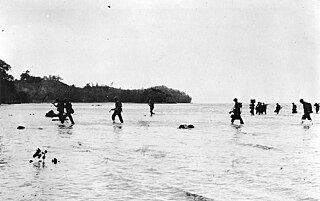
The Battle of Tulagi and Gavutu–Tanambogo was a land battle of the Pacific campaign of World War II, between the forces of the Imperial Japanese Navy and Allied ground forces. It took place 7–9 August 1942 on the Solomon Islands, during the initial Allied landings in the Guadalcanal campaign.
Tanambogo is a small island in the Central Province of Solomon Islands in the Nggela Islands group, which was also known as the Florida Islands under the British Solomon Islands Protectorate and during World War 2.

The Japanese destroyer Kikuzuki was one of twelve Mutsuki-class destroyers built for the Imperial Japanese Navy (IJN) during the 1920s. During the Pacific War, she participated in the Battle of Guam in December 1941 and the New Guinea and Solomon Islands Campaigns in 1942. Kikuzuki was destroyed during the invasion of Tulagi in May.

The Yokohama Air Group was an aircraft and airbase garrison unit of the Imperial Japanese Navy Air Service during the Pacific campaign of World War II.
RAAF Tanambogo was a Royal Australian Air Force seaplane advanced operating base on the islands of Tanambogo, Gaomi and Gavutu, British Solomon Islands, constructed in 1939. Tanambogo and Gavutu were connected by causeway.
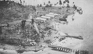
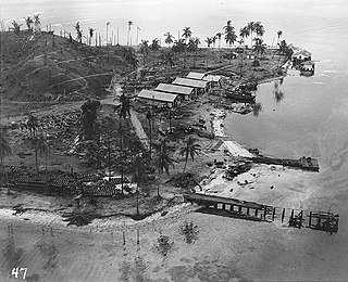
US Naval Base Solomons was a number of United States Navy bases in the Solomon Islands in the Pacific Ocean. Most were built by the US Navy Seabees, Naval Construction Battalions, during World War II as part of the Pacific War. In August 1942 the United States Armed Forces took the Guadalcanal in the Solomon, in the Battle of Guadalcanal. US Navy Seabees built a new base at Guadalcanal, Naval Base Guadalcanal and then on other islands in the Solomons.

