Related Research Articles

The Coral Sea is a marginal sea of the South Pacific off the northeast coast of Australia, and classified as an interim Australian bioregion. The Coral Sea extends 2,000 kilometres (1,200 mi) down the Australian northeast coast. Most of it is protected by the French Natural Park of the Coral Sea and the Australian Coral Sea Marine Park. The sea was the location for the Battle of the Coral Sea, a major confrontation during World War II between the navies of the Empire of Japan, and the United States and Australia.
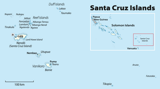
The Santa Cruz Islands are a group of islands in the Pacific Ocean, part of Temotu Province of the nation of Solomon Islands. They lie approximately 250 miles to the southeast of the Solomon Islands archipelago. The Santa Cruz Islands lie just north of the archipelago of Vanuatu, and are considered part of the Vanuatu rain forests ecoregion.
The Duff Islands are a small island group lying to the northeast of the Santa Cruz Islands in province of Temotu Province, in the nation of Solomon Islands. They are also sometimes known as the Wilson Islands.

The Reef Islands are a loose collection of 16 islands in the in Temotu Province, in the independent nation of Solomon Islands. These islands have historically also been known by the names of Swallow Islands and Matema Islands.

Temotu is the easternmost province of Solomon Islands. The province was formerly known as Santa Cruz Islands Province. It consists, essentially, of two chains of islands which run parallel to each other from the northwest to the southeast. Its area is 895 square kilometres.

Nukapu is one of the islands of the nation of Solomon Islands. It is in the Reef Islands group in Temotu Province; the easternmost province of the Solomons. The estimated terrain elevation above sea level is 15 metres.

Pio Island is an island in Solomon Islands province of Makira-Ulawa. It is situated 4 km north-west of Ugi Island. It is 2.7 km long and 1.5 km wide. The estimated terrain elevation above sea level is some 227 metres. The island has no villages. Coral reef surrounds the island, which is largest in the west and south of the island.
Nifiloli is an island in the Reef Islands, in Temotu Province, in the independent nation of Solomon Islands. The estimated terrain elevation above sea level is 19 metres. Despite its location in Melanesia, the population of the islands is Polynesian.
Fenualoa is the second largest island in the Reef Islands, in Temotu Province, in the nation of Solomon Islands.
Patteson Shoal is an outer reef in the Reef Islands, in Temotu Province, in the independent nation of Solomon Islands. It is located about 50 km northeast of Nupani. The shoal is named for John Coleridge Patteson.
Makalom is a small uninhabited island in the Reef Islands, in Temotu Province, in the nation of Solomon Islands. The island is 350 m long and 60 m wide, and is located on the south-west side of an oval-shaped atoll 2.5 km long and 1.5 km wide, some 4.8 km WNW of Pileni Island.
Ugi Island, also Uki Island, is an island in Solomon Islands; it is located in Makira-Ulawa Province and lies 11 km north of Makira Island.
Lomlom is the largest of the Reef Islands in Temotu Province, in the nation of Solomon Islands. It measures seven by four kilometres and separated from Fenualoa by a deep channel. The estimated terrain elevation above sea level is some 21 metres. Variant forms of the island's name are Fonofono and Lom lom.
Matema Island or Matema is of one of the Reef Islands in Temotu Province, of the independent nation of Solomon Islands.
Pigeon Island is of one of the Reef Islands in Temotu Province, in the independent nation of Solomon Islands, 360 nautical miles from Honiara. The island is 274 by 91 metres. In local language the island is called Ngarando, which means a faraway place.
Ngalo is of one of the Reef Islands located in Temotu Province, in the independent nation of Solomon Islands.
Nibanga Nendi is of one of the Reef Islands located in Temotu Province of the independent nation of Solomon Islands. The spelling of the island's name is various: Nibanga, Nimanu, Banga Ndeni.
Nibanga Temau is the easternmost island of the Reef Islands located in Temotu Province of the independent nation of Solomon Islands. Nibanga Temau has a length of 3.4 kilometres. The nearest large island is Lomlom.
Ngawa is one of the Reef Islands located in Temotu Province of the independent nation of Solomon Islands.
Ngandeli is one of the Reef Islands located in Temotu Province, in the independent nation of Solomon Islands.
References
- ↑ "Reef Islands - John Seach". Volcano Live. Retrieved 22 June 2018.
- ↑ Honan, Mark (1997). Solomon Islands. Lonely Planet. p. 253. ISBN 9780864424051 . Retrieved 12 June 2019.
10°15′S166°10′E / 10.250°S 166.167°E
| | This Solomon Islands location article is a stub. You can help Wikipedia by expanding it. |