Alsen, North Dakota

Last updated

Alsen, North Dakota
Post office in Alsen, North Dakota 7-19-2009.jpg
Post office in Alsen
ND Cavalier County Alsen.svg
Location of Alsen, North Dakota
Coordinates: 48°37′39″N98°42′21″W / 48.62750°N 98.70583°W / 48.62750; -98.70583 [1]
CountryUnited States
State North Dakota
County Cavalier
Founded1905
Area
[2]
  Total29.88 sq mi (77.38 km2)
  Land29.36 sq mi (76.03 km2)
  Water0.52 sq mi (1.35 km2)
Elevation
1,581 ft (482 m)
Population
 (2020)
  Total32
  Density1.09/sq mi (0.42/km2)
Time zone UTC-6 (CST)
  Summer (DST) UTC-5 (CDT)
ZIP code
58311
Area code 701
FIPS code 38-01740
GNIS feature ID1027688 [3]

Alsen is a city in Cavalier County, North Dakota, United States. The population was 32 at the 2020 census. [4] Alsen was founded in 1905.

Contents

Geography

Alsen is located on State Route 66, approximately 8 miles (13 km) west of Loma.

According to the United States Census Bureau, the city has a total area of 29.88 square miles (77.39 km2), of which 29.36 square miles (76.04 km2) is land and 0.52 square miles (1.35 km2) is water. [5]

Despite the small number of residents, Alsen and nearby Loma each cover approximately as much land within their corporate boundaries as Minot.

Demographics

Historical population
CensusPop.Note
1930 358
1940 312−12.8%
1950 114−63.5%
1960 228100.0%
1970 201−11.8%
1980 169−15.9%
1990 113−33.1%
2000 68−39.8%
2010 35−48.5%
2020 32−8.6%
2021 (est.)30 [6] −6.2%
U.S. Decennial Census [7]
2020 Census [4]

2010 census

As of the census of 2010, there were 35 people, 16 households, and 11 families residing in the city. The population density was 1.2 inhabitants per square mile (0.5/km2). There were 28 housing units at an average density of 1.0 per square mile (0.4/km2). The racial makeup of the city was 100.0% White.

There were 16 households, of which 31.3% had children under the age of 18 living with them, 56.3% were married couples living together, 6.3% had a female householder with no husband present, 6.3% had a male householder with no wife present, and 31.3% were non-families. 25.0% of all households were made up of individuals, and 12.6% had someone living alone who was 65 years of age or older. The average household size was 2.19 and the average family size was 2.64.

The median age in the city was 50.8 years. 22.9% of residents were under the age of 18; 0.0% were between the ages of 18 and 24; 17.2% were from 25 to 44; 25.7% were from 45 to 64; and 34.3% were 65 years of age or older. The gender makeup of the city was 54.3% male and 45.7% female.

2000 census

As of the census of 2000, there were 68 people, 25 households, and 19 families residing in the city. The population density was 2.3 people per square mile (0.9/km2). There were 45 housing units at an average density of 1.5 per square mile (0.6/km2). The racial makeup of the city was 97.06% White, and 2.94% from two or more races. Hispanic or Latino of any race were 1.47% of the population.

There were 25 households, out of which 32.0% had children under the age of 18 living with them, 64.0% were married couples living together, 8.0% had a female householder with no husband present, and 24.0% were non-families. 20.0% of all households were made up of individuals, and 12.0% had someone living alone who was 65 years of age or older. The average household size was 2.72 and the average family size was 3.21.

In the city, the population was spread out, with 32.4% under the age of 18, 2.9% from 18 to 24, 27.9% from 25 to 44, 23.5% from 45 to 64, and 13.2% who were 65 years of age or older. The median age was 41 years. For every 100 females, there were 106.1 males. For every 100 females age 18 and over, there were 100.0 males.

The median income for a household in the city was $57,500, and the median income for a family was $65,000. Males had a median income of $51,250 versus $41,250 for females. The per capita income for the city was $12,982. There were 22.7% of families and 44.2% of the population living below the poverty line, including 70.6% of under eighteens and 28.6% of those over 64.

History

The former high school in Alsen, which closed due to low enrollment in 1980, recorded the longest basketball winning streak in North Dakota basketball history, at 79 games from 1956 to 1959.

Related Research Articles

<span class="mw-page-title-main">Eagle, Idaho</span> City in Idaho, United States

Eagle is a city in the western United States in Ada County, Idaho, ten miles (16 km) northwest of downtown Boise. The population was 30,346 at the time of the 2020 census.

<span class="mw-page-title-main">Woodburn, Iowa</span> City in Iowa, United States

Woodburn is a city in Clarke County, Iowa, United States. The population was 146 at the time of the 2020 census.

<span class="mw-page-title-main">Randalia, Iowa</span> City in Iowa, United States

Randalia is a city in Fayette County, Iowa, United States. The population was 51 at the time of the 2020 census.

<span class="mw-page-title-main">Pleasant Plain, Iowa</span> City in Iowa, United States

Pleasant Plain is a city in northeast Penn Township, Jefferson County, Iowa, United States. At the time of the 2020 census, the population was 84.

<span class="mw-page-title-main">Dixon, Iowa</span> City in Iowa, United States

Dixon is a city in Scott County, Iowa, United States. The population was 202 at the time of the 2020 census.

<span class="mw-page-title-main">Chickamaw Beach, Minnesota</span> City in Minnesota, United States

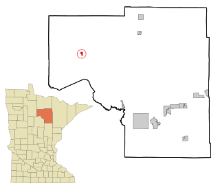
Chickamaw Beach is a city in Cass County, Minnesota, United States. The population was 114 at the 2010 census. It is part of the Brainerd Micropolitan Statistical Area.

<span class="mw-page-title-main">Squaw Lake, Minnesota</span> City in Minnesota, United States

Squaw Lake is a city in Itasca County, Minnesota, United States. The population was 107 at the 2010 census.

<span class="mw-page-title-main">Warba, Minnesota</span> City in Minnesota, United States

Warba is a city in Itasca County, Minnesota, United States. The population was 181 at the 2010 census.

<span class="mw-page-title-main">Holt, Minnesota</span> City in Minnesota, United States

Holt is a city in Marshall County, Minnesota, United States. The population was 90 at the 2020 census.

<span class="mw-page-title-main">Erhard, Minnesota</span> City in Minnesota, United States

Erhard is a city in Otter Tail County, Minnesota, United States. The population was 132 at the 2020 census.

<span class="mw-page-title-main">Urbank, Minnesota</span> City in Minnesota, United States

Urbank is a city in Otter Tail County, Minnesota, United States. The population was 52 at the 2020 census.

<span class="mw-page-title-main">St. Rosa, Minnesota</span> City in Minnesota, United States

Saint Rosa is a city in Stearns County, Minnesota, United States. The population was 68 at the 2010 census. It is part of the St. Cloud Metropolitan Statistical Area.

<span class="mw-page-title-main">Velda City, Missouri</span> City in Missouri, United States

Velda City is a city in St. Louis County, Missouri, United States. The population was 1,420 at the 2010 census.

<span class="mw-page-title-main">Fifty Lakes, Minnesota</span> City in Minnesota, United States

Fifty Lakes is a city in Crow Wing County, Minnesota, United States. The population was 387 at the 2010 census. It is part of the Brainerd Micropolitan Statistical Area.

<span class="mw-page-title-main">Loma, North Dakota</span> City in North Dakota, United States

Loma is a city in Cavalier County, North Dakota, United States. The population was 10 at the 2020 census. Loma was founded in 1905.

<span class="mw-page-title-main">Niagara, North Dakota</span> City in North Dakota, United States

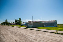
Niagara is a city in Grand Forks County, North Dakota, United States. It is part of the "Grand Forks, ND-MN Metropolitan Statistical Area" or "Greater Grand Forks". The population was 46 at the 2020 census. Niagara was founded in 1883.

<span class="mw-page-title-main">Unity, Oregon</span> City in Oregon, United States

Unity is a city in Baker County, Oregon, United States, located in the Burnt River Valley. The population was 71 at the 2010 census.

<span class="mw-page-title-main">Follansbee, West Virginia</span> City in West Virginia, United States

Follansbee is a city in Brooke County, West Virginia, United States, located along the Ohio River. The population was 2,853 at the 2020 census, a decrease from 2,986 at the 2010 census. It is part of the Weirton–Steubenville metropolitan area. The city was named after the Follansbee brothers, the proprietors of a local steel mill.

<span class="mw-page-title-main">Harman, West Virginia</span> Town in West Virginia, United States

Harman is a town in Randolph County, West Virginia, United States. The population was 96 at the 2020 census.

<span class="mw-page-title-main">Minneiska, Minnesota</span> City in Minnesota, United States

Minneiska is a city in Wabasha and Winona counties in the U.S. state of Minnesota. The population was 111 at the 2010 census.

References

  1. "US Gazetteer files: 2010, 2000, and 1990". United States Census Bureau. February 12, 2011. Retrieved April 23, 2011.
  2. "ArcGIS REST Services Directory". United States Census Bureau. Retrieved September 20, 2022.
  3. "US Board on Geographic Names". United States Geological Survey. October 25, 2007. Retrieved January 31, 2008.
  4. 1 2 "Explore Census Data". United States Census Bureau . Retrieved June 16, 2022.
  5. "US Gazetteer files 2010". United States Census Bureau. Archived from the original on January 25, 2012. Retrieved June 14, 2012.
  6. "City and Town Population Totals: 2020-2021". United States Census Bureau. July 12, 2022. Retrieved July 12, 2022.
  7. United States Census Bureau. "Census of Population and Housing" . Retrieved August 30, 2013.