Loma, North Dakota

Last updated
Loma, North Dakota
Loma, North Dakota 7-19-2009.jpg
Building in Loma
ND Cavalier County Loma.svg
Location of Loma, North Dakota
Coordinates: 48°38′16″N98°31′31″W / 48.63778°N 98.52528°W / 48.63778; -98.52528 Coordinates: 48°38′16″N98°31′31″W / 48.63778°N 98.52528°W / 48.63778; -98.52528
CountryUnited States
State North Dakota
County Cavalier
Founded1905
Area
[1]
  Total26.85 sq mi (69.54 km2)
  Land26.46 sq mi (68.53 km2)
  Water0.39 sq mi (1.01 km2)
Elevation
1,572 ft (479 m)
Population
 (2020)
  Total10
  Density0.38/sq mi (0.15/km2)
Time zone UTC-6 (CST)
  Summer (DST) UTC-5 (CDT)
ZIP code
58311
Area code 701
FIPS code 38-47660
GNIS feature ID1029963 [2]

Loma is a city in Cavalier County, North Dakota, United States. The population was 10 at the 2020 census. [3] Loma was founded in 1905.

Contents

Geography

Loma is located at 48°38′16″N98°31′31″W / 48.63778°N 98.52528°W / 48.63778; -98.52528 (48.637896, -98.525406). [4]

According to the United States Census Bureau, the city has a total area of 26.83 square miles (69.49 km2), of which 26.43 square miles (68.45 km2) is land and 0.40 square miles (1.04 km2) is water. [5]

Despite the small number of residents, Loma and nearby Alsen each cover approximately as much land within their corporate boundaries as Minot.

Demographics

Historical population
CensusPop.
1930 293
1940 256−12.6%
1950 53−79.3%
1960 20−62.3%
1970 85325.0%
1980 39−54.1%
1990 27−30.8%
2000 21−22.2%
2010 16−23.8%
2020 10−37.5%
2021 (est.)8 [6] −20.0%
U.S. Decennial Census [7]
2020 Census [3]

2010 census

As of the census of 2010, there were 16 people, 7 households, and 3 families residing in the city. The population density was 0.6 inhabitants per square mile (0.2/km2). There were 13 housing units at an average density of 0.5 per square mile (0.2/km2). The racial makeup of the city was 100.0% White.

There were 7 households, of which 28.6% had children under the age of 18 living with them, 28.6% were married couples living together, 14.3% had a female householder with no husband present, and 57.1% were non-families. 57.1% of all households were made up of individuals, and 28.6% had someone living alone who was 65 years of age or older. The average household size was 2.29 and the average family size was 4.00.

The median age in the city was 43 years. 25% of residents were under the age of 18; 12.6% were between the ages of 18 and 24; 12.5% were from 25 to 44; 31.3% were from 45 to 64; and 18.8% were 65 years of age or older. The gender makeup of the city was 56.3% male and 43.8% female.

2000 census

As of the census of 2000, there were 21 people, 9 households, and 7 families residing in the city. The population density was 0.8 people per square mile (0.3/km2). There were 10 housing units at an average density of 0.4 per square mile (0.1/km2). The racial makeup of the city was 100.00% White.

There were 9 households, out of which 11.1% had children under the age of 18 living with them, 55.6% were married couples living together, 11.1% had a female householder with no husband present, and 22.2% were non-families. 22.2% of all households were made up of individuals, and none had someone living alone who was 65 years of age or older. The average household size was 2.33 and the average family size was 2.71.

In the city, the population was spread out, with 19.0% under the age of 18, 4.8% from 18 to 24, 19.0% from 25 to 44, 19.0% from 45 to 64, and 38.1% who were 65 years of age or older. The median age was 58 years. For every 100 females, there were 110.0 males. For every 100 females age 18 and over, there were 112.5 males.

The median income for a household in the city was $63,750, and the median income for a family was $63,750. Males had a median income of $43,750 versus $18,750 for females. The per capita income for the city was $18,245. None of the population and none of the families were below the poverty line.

Related Research Articles

<span class="mw-page-title-main">Las Lomas, California</span> Census-designated place in California, United States

Las Lomas is an unincorporated community and census-designated place (CDP) in Monterey County, California, United States. Las Lomas is located 7 miles (11 km) north-northwest of Prunedale. The elevation is 43 feet (13 m). The population was 3,046 at the 2020 census.

<span class="mw-page-title-main">Mira Loma, California</span> Former census-designated place in California, United States

Mira Loma, now officially part of Jurupa Valley, was a census-designated place (CDP) in Riverside County, California, United States. Its population was 21,930 in the 2010 census, up from 17,617 in the 2000 census.

<span class="mw-page-title-main">Northdale, Florida</span> Census-designated place in Florida, United States

Northdale is an unincorporated census-designated place in Hillsborough County, Florida, United States. Northdale was named by the combination of the words in North Dale Mabry, the main highway through the Northdale area. The population was 22,079 at the 2010 census.

<span class="mw-page-title-main">Nicholls, Georgia</span> City in Georgia, United States

Nicholls is a city in Coffee County, Georgia, United States. The population was 2,798 as of the 2010 census, up from 1,008 in 2000, due to counting of the Coffee County Correctional Facility population within the city limits. This facility is privately owned and operated by CoreCivic.

<span class="mw-page-title-main">Stonington, Illinois</span> Village in Illinois, United States

Stonington is a village in Christian County, Illinois, United States. The population was 837 at the 2020 census.

<span class="mw-page-title-main">Buck Grove, Iowa</span> City in Iowa, United States

Buck Grove is a city in Crawford County, Iowa, United States. The population was 34 at the 2020 census.

<span class="mw-page-title-main">West Falmouth, Massachusetts</span> Census-designated place in Massachusetts, United States

West Falmouth is a census-designated place (CDP) in the town of Falmouth in Barnstable County, Massachusetts, United States. The population was 1,738 at the 2010 census.

<span class="mw-page-title-main">Turtle River, Minnesota</span> City in Minnesota, United States

Turtle River is a town in Beltrami County, Minnesota, United States. The population was 77 at the 2010 census. The elevation is 1,332 ft (406m). It is approximately 17 miles northeast of Bemidji, where most community services are available. Turtle River consists of two stores, a restaurant, a gas station, and a church.

<span class="mw-page-title-main">Chickamaw Beach, Minnesota</span> City in Minnesota, United States

Chickamaw Beach is a city in Cass County, Minnesota, United States. The population was 114 at the 2010 census. It is part of the Brainerd Micropolitan Statistical Area.

<span class="mw-page-title-main">Ottertail, Minnesota</span> City in Minnesota, United States

Ottertail is a city in Otter Tail County, Minnesota, United States. The population was 629 at the 2020 census.

<span class="mw-page-title-main">Loma Linda, Missouri</span> Village in Missouri, United States

Loma Linda is a village in Newton County, Missouri, United States. The population was 725 at the 2010 census. It is part of the Joplin, Missouri Metropolitan Statistical Area. The village, a collection of homes and properties surrounding the golf course and country club of the name, was incorporated in 1995. Loma Linda Country Club was created by Joe Blau of New York and the late Ted Hoffman in 1971. Until August 2005, the golf professional at Loma Linda was Benny Pell.

<span class="mw-page-title-main">Loma, Montana</span> Census-designated place in Montana, United States

Loma is a census-designated place (CDP) in Chouteau County, Montana, United States. The population was 85 at the 2010 census.

<span class="mw-page-title-main">Gardena, North Dakota</span> City in North Dakota, United States

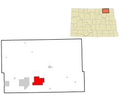
Gardena is a city in Bottineau County, North Dakota, United States. The population was 24 at the 2020 census. Gardena was founded in 1905.

<span class="mw-page-title-main">Alsen, North Dakota</span> City in North Dakota, United States

Alsen is a city in Cavalier County, North Dakota, United States. The population was 32 at the 2020 census. Alsen was founded in 1905.

<span class="mw-page-title-main">Rentiesville, Oklahoma</span> Town in Oklahoma, United States

Rentiesville is a town in McIntosh County, Oklahoma, United States. It was founded in 1903 and named for William Rentie, a local landowner. It was one of 50 all-black towns in Oklahoma and one of 13 that still survives. The population was 128 at the 2010 census, an increase of 25.5 percent from 102 in 2000.

<span class="mw-page-title-main">Lane, South Carolina</span> Town in South Carolina, United States

Lane is a town in Williamsburg County, South Carolina, United States. The population was 508 at the 2010 census.

<span class="mw-page-title-main">Urbanna, Virginia</span> Town in Virginia, United States

Urbanna is a town in Middlesex County, Virginia, United States. Urbanna means “City of Anne” and was named in honor of England's Queen Anne. The population was 476 at the 2010 census.

<span class="mw-page-title-main">Lyman, Washington</span> Town in Washington, United States

Lyman is a town in Skagit County, Washington, United States. The population was 438 at the 2010 census. It is included in the Mount Vernon-Anacortes, Washington Metropolitan Statistical Area.

<span class="mw-page-title-main">Chesapeake, West Virginia</span> Town in West Virginia, United States

Chesapeake is a town in Kanawha County, West Virginia, United States. The population was 1,336 at the 2020 census. The town is situated on the Kanawha River. Chesapeake was incorporated on November 1, 1948 as recorded in Book 67 Page 123-124 and named for the Chesapeake and Ohio Railway, which has served the community since 1873. It is also the hometown of NFL player Chris Massey, long snapper for the St. Louis Rams. The current Mayor of Chesapeake is Jack Lavender.

<span class="mw-page-title-main">Minneiska, Minnesota</span> City in Minnesota, United States

Minneiska is a city in Wabasha and Winona counties in the U.S. state of Minnesota. The population was 111 at the 2010 census.

References

  1. "ArcGIS REST Services Directory". United States Census Bureau. Retrieved September 20, 2022.
  2. "US Board on Geographic Names". United States Geological Survey. October 25, 2007. Retrieved January 31, 2008.
  3. 1 2 "Explore Census Data". United States Census Bureau . Retrieved June 16, 2022.
  4. "US Gazetteer files: 2010, 2000, and 1990". United States Census Bureau. February 12, 2011. Retrieved April 23, 2011.
  5. "US Gazetteer files 2010". United States Census Bureau. Archived from the original on January 12, 2012. Retrieved June 14, 2012.
  6. "City and Town Population Totals: 2020-2021". United States Census Bureau. July 12, 2022. Retrieved July 12, 2022.
  7. United States Census Bureau. "Census of Population and Housing" . Retrieved August 30, 2013.