Altamont, North Carolina

Last updated
Altamont
Unincorporated community
USA North Carolina location map.svg
Red pog.svg
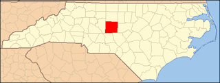
Altamont
Location within the state of North Carolina
Coordinates: 35°59′27″N81°56′39″W / 35.99083°N 81.94417°W / 35.99083; -81.94417 Coordinates: 35°59′27″N81°56′39″W / 35.99083°N 81.94417°W / 35.99083; -81.94417
Country United States
State North Carolina
County Avery County
Elevation 3,268 ft (996 m)
Time zone Eastern (EST) (UTC-5)
  Summer (DST) EDT (UTC-4)
ZIP code 28657
Area code(s) 828
GNIS feature ID 1018807 [1]

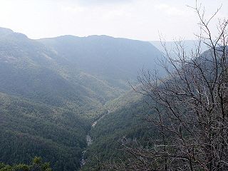
Altamont is an unincorporated community in Avery County, North Carolina, United States. The community is located along US 221/NC 194 (Linville Falls Highway), between the town of Crossnore and the community of Linville Falls. Altamont translates to "High Mountain."

Avery County, North Carolina County in the United States

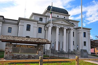
Avery County is a county located in the U.S. state of North Carolina. As of the 2010 census, the population was 17,797. The county seat is Newland. The county seat was initially established in Elk Park when the county was first formed, but was moved to Newland upon completion of the courthouse in 1912. Founded in 1911, it is the youngest of North Carolina's 100 counties.

North Carolina State of the United States of America

North Carolina is a state in the southeastern region of the United States. It borders South Carolina and Georgia to the south, Tennessee to the west, Virginia to the north, and the Atlantic Ocean to the east. North Carolina is the 28th-most extensive and the 9th-most populous of the U.S. states. The state is divided into 100 counties. The capital is Raleigh, which along with Durham and Chapel Hill is home to the largest research park in the United States. The most populous municipality is Charlotte, which is the second-largest banking center in the United States after New York City.

U.S. Route 221 highway in the United States

U.S. Route 221 (US 221) is a 734-mile-long (1,181 km) spur of U.S. Route 21. It travels from Perry, Florida, at US 19/US 98/US 27 Alternate to Lynchburg, Virginia, at US 29 Business. It travels through the states of Florida, Georgia, South Carolina, North Carolina, and Virginia. It travels through the cities of Valdosta, Georgia; Spartanburg, South Carolina; Marion, North Carolina; Roanoke, Virginia; and Lynchburg, Virginia.

The Ray Wiseman House was listed on the National Register of Historic Places in 1996. [2]

Ray Wiseman House

Ray Wiseman House is a historic home located at Altamont, Avery County, North Carolina. It was built in 1941, and is a one-story, Arts-and-Crafts bungalow-reflecting the American Craftsman influence. It is considered one of the best examples of Arts and Crafts architecture in the region. The home is a good example of an upper middle class home of the 1940s. The interior includes well crafted chestnut woodwork and red oak floors. The floor plan includes two large bedroom suites with a private sunroom for one and a large attic/loft space with enclosed stairway. The sun room still features rare 1940's original wall paper. The original plumbing fixtures stamped (1941) can still be found in the original main bathroom off the center hall and a modern second bathroom has been added to the master bedroom. It is constructed of native river rock and is approximately 1,400 square feet. It sits on 1.5 acres of land carved out of hills to form the original roadbed for the highway in front of the property.

National Register of Historic Places federal list of historic sites in the United States

The National Register of Historic Places (NRHP) is the United States federal government's official list of districts, sites, buildings, structures, and objects deemed worthy of preservation for their historical significance. A property listed in the National Register, or located within a National Register Historic District, may qualify for tax incentives derived from the total value of expenses incurred preserving the property.

See also

Related Research Articles

Falls Lake State Recreation Area North Carolina state park in Durham and Wake Counties

Falls Lake State Recreation Area is a North Carolina state park in Durham and Wake Counties, North Carolina in the United States. Near Wake Forest, North Carolina, it covers 5,035 acres (20.38 km2) along the shores of 12,410-acre (50.2 km2) Falls Lake.

Linville Gorge Wilderness

The Linville Gorge Wilderness is the third largest wilderness area in North Carolina and one of only two wilderness gorges in the Southern United States. Maintained by the United States Forest Service, it comprises 11,786 acres (47.7 km2) around the Linville River, and is situated inside the Pisgah National Forest. The river is approximately 1,400 feet below the ridge, thus hiking in and out of the Gorge is challenging and enjoyable for those who like serious hiking. The plant and animal community is extremely diverse, with a dense hardwood/pine forest and a wide variety of smaller trees and other plants as well as bear, fox, raccoon, trout, grouse, wild turkey, vultures, owls, hawks, copperheads, and timber rattlesnakes.

Linville Falls Waterfall located in the Blue Ridge Mountains

Linville Falls is a waterfall located in the Blue Ridge Mountains of North Carolina in the United States. The falls move in several distinct steps, beginning in a twin set of upper falls, moving down a small gorge, and culminating in a high-volume 45-foot (14 m) drop. It is named for the Linville River, which goes over the falls. Linville Falls has the highest volume of any waterfall on the Northern Edge of the Blue Ridge Mountains.

Linville River river in the United States of America

The Linville River is a river in western North Carolina. The river begins in the slopes of Peak Mountain, Sugar Mountain and Flattop Mountain, in the Linville Gap. As it goes south through Avery County, it passes through the communities of Grandfather, Linville, Pineola, Crossnore and finally at Linville Falls. After entering Burke County at the community of Linville Falls, the river becomes the centerpiece of the Linville Falls and the Linville Gorge, an area referred to as "the Grand Canyon of North Carolina." After approximately 30 miles (48 km), the river ends at Lake James and the Catawba River; the original confluence with the Catawba River has been flooded by the creation of the reservoir in 1923.

Linville, North Carolina Unincorporated community in North Carolina, United States

Linville is an unincorporated community in Avery County, North Carolina, United States. Centered just south of US 221 and NC 105, the community is known as a summer mountain resort and host of the Grandfather Mountain Highland Games, the largest modern Highland games in North Carolina.

Falls, North Carolina, is an unincorporated community in Wake County, North Carolina on Old Falls of Neuse Road, between Raleigh and Wake Forest, near the Wakefield Plantation development. Falls Dam, on the Neuse River, is within the community. It lies at an elevation of 210 feet.

Linville Falls, North Carolina Unincorporated community in North Carolina, United States

Linville Falls is an unincorporated community at the junction of Avery, Burke, and McDowell counties in the U.S. state of North Carolina. The community is named after Linville Falls, a nearby waterfall in the Linville Gorge Wilderness.

National Register of Historic Places listings in Mecklenburg County, North Carolina Wikimedia list article

This list includes properties and districts listed on the National Register of Historic Places in Mecklenburg County, North Carolina. Click the "Map of all coordinates" link to the right to view an online map of all properties and districts with latitude and longitude coordinates in the table below.

National Register of Historic Places listings in Cumberland County, North Carolina Wikimedia list article

The following is a list of properties and districts on the National Register of Historic Places in Cumberland County, North Carolina. Some are listed as part of the "Fayetteville MRA", which means they were part of a multiple property submission, also known as a "Multiple Resource Area."

National Register of Historic Places listings in Durham County, North Carolina Wikimedia list article

This list includes properties and districts listed on the National Register of Historic Places in Durham County, North Carolina. Click the "Map of all coordinates" link to the right to view an online map of all properties and districts with latitude and longitude coordinates in the table below.

National Register of Historic Places listings in Wilson County, North Carolina Wikimedia list article

This list includes properties and districts listed on the National Register of Historic Places in Wilson County, North Carolina. Click the "Map of all coordinates" link to the right to view a Google map of all properties and districts with latitude and longitude coordinates in the table below.

National Register of Historic Places listings in Watauga County, North Carolina Wikimedia list article

This list includes properties and districts listed on the National Register of Historic Places in Watauga County, North Carolina. Click the "Map of all coordinates" link to the right to view a Google map of all properties and districts with latitude and longitude coordinates in the table below.

National Register of Historic Places listings in Macon County, North Carolina Wikimedia list article

This list includes properties and districts listed on the National Register of Historic Places in Macon County, North Carolina. Click the "Map of all coordinates" link to the right to view a Google map of all properties and districts with latitude and longitude coordinates in the table below.

National Register of Historic Places listings in Randolph County, North Carolina Wikimedia list article

This list includes properties and districts listed on the National Register of Historic Places in Randolph County, North Carolina. Click the "Map of all coordinates" link to the right to view a Google map of all properties and districts with latitude and longitude coordinates in the table below.

North Carolina Highway 183 highway in North Carolina

North Carolina Highway 183 (NC 183) is a primary state highway in the U.S. state of North Carolina. It traverses from US 221, in the community of Linville Falls, to NC 181, near the community of Jonas Ridge.

Edom, Virginia Unincorporated community in Virginia, United States

Edom is an unincorporated community located in Rockingham County, in the U.S. state of Virginia. It is located along State Route 42 at the crossroads with State Route 721, north of Harrisonburg and southeast of Singers Glen. Linville Creek flows through the village.

Linville, Virginia Unincorporated community in Virginia, United States

Linville is an unincorporated community located in Rockingham County, in the U.S. state of Virginia. It is located 6 miles north of Harrisonburg, Virginia. It contains the Linville United Church of Christ.

Linville Historic District

Linville Historic District is a historic school campus and national historic district located at Linville, Avery County, North Carolina. It encompasses 96 contributing buildings and 4 contributing structures in the historic core of Linville. The buildings date between about 1892 and 1940, and include shingle-or chestnut bark-covered resort buildings and the second generation of houses flanking the first and eighteenth fairways of the golf course. Notable buildings include the Hemlock Cottage, Dormiecroft, "Honeymoon" Cottage, Presbyterian Church, The Studio, the VanLandingham House, and All Saints Episcopal Church.

Linville Falls Tavern

Linville Falls Tavern, now known as Famous Louise's Rock House Restaurant, is a historic tavern located at Linville Falls, Avery County and McDowell County, North Carolina. It was built in 1936, and is a 1 1/2-story, eight bay, native stone Rustic Revival-style building. It has a hipped roof with dormer and two stone chimneys.

Franklin-Penland House

Franklin-Penland House, also known as Theodore C. Franklin House, Stokes Penland House, and Linville Falls Post Office, is a historic home located at Linville Falls, Burke County, North Carolina. It was built about 1883, and is a two-story, three-bay, frame I-house with a two-story rear ell. It features a full-width, attached two-tiered shed roof porch added about 1915. Also on the property is the former U.S. Post Office, Linville Falls, N.C., building. The one-room front gable frame building was built in 1907 and housed the Linville Falls post office until 1925.

References