
Watauga County is a county located in the U.S. state of North Carolina. As of the 2010 census, the population was 51,079. Its county seat and largest town is Boone. The county is in an exceptionally mountainous region. It is the home of Appalachian State University, which has approximately 15,000 students.

Mitchell County is a county located in the U.S. state of North Carolina. As of the 2010 census, the population was 15,579. Its county seat is Bakersville, population 454 (2010), elevation 2470 ft..

Caldwell County is a county in the U.S. state of North Carolina, in the foothills of the Appalachian Mountains. As at the 2010 census, the population was 83,029. Its county seat is Lenoir.
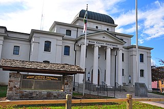
Avery County is a county located in the U.S. state of North Carolina. As of the 2010 census, the population was 17,797. The county seat is Newland. The county seat was initially established in Elk Park when the county was first formed, but was moved to Newland upon completion of the courthouse in 1912. Founded in 1911, it is the youngest of North Carolina's 100 counties.

Morganton is a city in and the county seat of Burke County, North Carolina, United States. The population was 16,918 at the 2010 census.
U.S. Route 19E (US 19E) is a divided highway of US 19 in the U.S. states of North Carolina and Tennessee. The U.S. Highway, which is complemented by US 19W to the west, travels 75.9 miles (122.1 km) from US 19 and US 19W at Cane River, North Carolina, north to US 11E, US 19, and US 19W in Bluff City, Tennessee. US 19E connects Asheville, North Carolina, and Bristol, Tennessee, with Burnsville, Spruce Pine, and Elk Park in North Carolina and Roan Mountain and Elizabethton in Tennessee. US 19E also has an unsigned concurrency with Tennessee State Route 37 (SR 37) for its entire course in Tennessee.

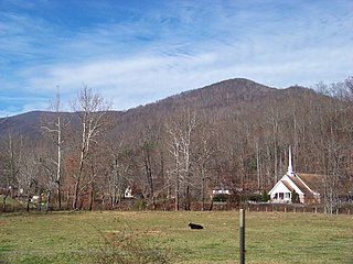
Western North Carolina is the region of North Carolina which includes the Appalachian Mountains; it is often known geographically as the state's Mountain Region. It contains the highest mountains in the Eastern United States, with 125 peaks rising to over 5,000 feet elevation. Western North Carolina is sometimes included with upstate South Carolina as the "Western Carolinas", which is counted as a single media market. The region covers an area of about 11,000 square miles (28,000 km2), and is roughly the size of the state of Massachusetts. The population of the region, as measured by the 2010 U.S. Census, is 1,473,241, which is approximately 15% of North Carolina's total population.

Linville is an unincorporated community in Avery County, North Carolina, United States. Centered just south of US 221 and NC 105, the community is known as a summer mountain resort and host of the Grandfather Mountain Highland Games, the largest modern Highland games in North Carolina.

Minneapolis is a community located along US 19-E in Avery County, North Carolina. It shares its name with two other cities nationwide: another small town in Kansas, and the much larger and more famous city of Minneapolis, Minnesota, that state's largest city.
Three Mile is an unincorporated community in Avery County, North Carolina, United States. The community is located along NC 194 ; the name is derived from the distance of three miles between US 19-E to US 221.
Vale is an Unincorporated community in Avery County, North Carolina, United States. It is located northwest of Newland on Old Toe River Road.
Pineola is an unincorporated community in Avery County, North Carolina. Its boundaries, in general, span a three-mile radius from the intersection of U.S. Route 221 (US 221) and North Carolina Highway 181 (NC 181).
Cranberry is an unincorporated community in Avery County, North Carolina, United States. The community was founded in 1850 and was named after Cranberry Creek, which flows in the area. The community is located one mile south from the town of Elk Park, along US 19E.
Altamont is an unincorporated community in Avery County, North Carolina, United States. The community is located along US 221/NC 194, between the town of Crossnore and the community of Linville Falls. Altamont translates to "High Mountain."
Roaring Creek is an unincorporated community in Avery County, North Carolina, United States. The community was named after Roaring Creek, which flows in the area. The community is located along US 19-E, between the communities of Frank and Plumtree.
Plumtree is an unincorporated community in Avery County, North Carolina, United States. The community is located along US 19-E, between the communities of Roaring Creek and Ingalls.

Frank is an unincorporated community in Avery County, North Carolina, United States. The community is located along US 19-E, between the communities of Minneapolis and Roaring Creek.
Heaton is an unincorporated community in Avery County, North Carolina, United States. The community is located along NC 194, centered at the Heaton Bridge, which crosses over the Elk River.
Montezuma is an unincorporated community in Avery County, North Carolina, United States. Before its founding in 1883, it had two variant names, Aaron and Bull Scrape. The community is located on Old State Highway 181 and is on the Eastern Continental Divide.
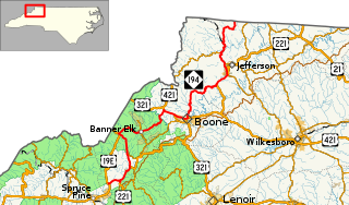
North Carolina Highway 194 (NC 194) is a primary state highway in the U.S. state of North Carolina. Primarily in the High Country, it runs from US 19E, in Ingalls, to the Virginia state line, near Helton.

