Montezuma or Moctezuma may refer to:
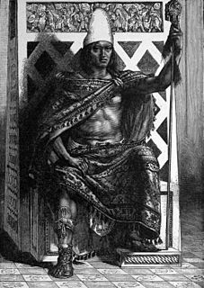
Moctezuma Xocoyotzinmodern Nahuatl pronunciation (help·info)),, variant spellings include Motecuhzomatzin, Montezuma, Moteuczoma, Motecuhzoma, Motēuczōmah, Muteczuma, and referred to retroactively in European sources as Moctezuma II, was the ninth tlatoani or ruler of the Aztec Empire, reigning from 1502 to 1520. The first contact between the indigenous civilizations of Mesoamerica and Europeans took place during his reign, and he was killed during the initial stages of the Spanish conquest of the Aztec Empire, when conquistador Hernán Cortés and his men fought to take over the Aztec capital Tenochtitlán.
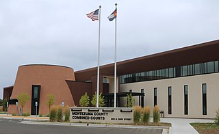
Montezuma County is the southwesternmost of the 64 counties in the U.S. state of Colorado. As of the 2010 census, the population was 25,535. The county seat is Cortez.
Shiloh, Shilo, or Silo is mainly known as the name of the biblical city which preceded Jerusalem as the central worship site of the early Israelites. One Bible line might indicate that it was also used as the personal name of a biblical figure.

Lake Montezuma is a census-designated place (CDP) in Yavapai County in the U.S. state of Arizona. The population was 3,344 at the 2000 census. The CDP includes the communities of Rimrock and McGuireville. Located along Interstate 17, it is 20 miles (32 km) south of Sedona and 8 miles (13 km) north of Camp Verde in central Arizona's Verde Valley.

Cortez is a Home Rule Municipality that is the county seat and the most populous municipality of Montezuma County, Colorado, United States. The city population was 8,482 at the 2010 United States Census.

Montezuma Castle National Monument protects a set of well-preserved dwellings located in Camp Verde, Arizona, which were built and used by the Sinagua people, a pre-Columbian culture closely related to the Hohokam and other indigenous peoples of the southwestern United States, between approximately 1100 and 1425 AD. The main structure comprises five stories and about 45 to 60 rooms and was built over the course of three centuries.

Montezuma National Wildlife Refuge is a wildlife preserve operated by the United States Fish and Wildlife Service, encompassing part of the Montezuma Swamp at the north end of Cayuga Lake. The 10,004-acre (40.48 km2) preserve is composed of swamps, pools and channels and is a stopping point for migratory birds.

The Sierra Estrella is a mountain range located southwest of Phoenix, Arizona. Much of the range falls within the Gila River Indian Reservation, but 14,400 acres (5,800 ha) of BLM land is protected as the Sierra Estrella Wilderness.
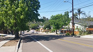
The College Area is a residential community in the Mid-City region of San Diego, California, United States. The College Area is dominated by San Diego State University, after which the area is named. Several neighborhoods in the College Area were developed in the 1930s, with others becoming established in the post-war period. The College Area is bordered on the west by Kensington and Talmadge and on the east by the city of La Mesa. El Cajon Boulevard is a busy shopping district; additional retail is in development near SDSU.

The Sinagua were a pre-Columbian culture that occupied a large area in central Arizona from the Little Colorado River, near Flagstaff, to the Verde River, near Sedona, including the Verde Valley, area around San Francisco Mountain, and significant portions of the Mogollon Rim country, between approximately 500 CE and 1425 CE.
New York State Route 90 (NY 90) is a north–south state highway in the Finger Lakes region of New York in the United States. All but five of the route's 53 miles (85 km) are located in Cayuga County, with the remaining 5 miles (8 km) situated in Cortland County. The southern terminus of the route is at an intersection with U.S. Route 11 (US 11) and NY 41 in the village of Homer. Its northern terminus is at a junction with NY 31 in the town of Montezuma. Although the route is signed as north–south, the portion of NY 90 from King Ferry to Homer follows an east–west alignment.

The Montezuma Falls, a horsetail waterfall on a minor tributary to the Pieman River, is located on the West Coast Range of Tasmania, Australia.

State Route 257 is a primary state highway in the U.S. state of Virginia. The state highway runs 18.04 miles (29.03 km) from SR 902 and SR 924 near Briery Branch east to Interstate 81 (I-81) near Mount Crawford. SR 257 connects I-81 and U.S. Route 11 with Bridgewater and Dayton, between which the highway runs concurrently with SR 42. The state highway also provides access to Bridgewater College and connects Dayton with the western Rockingham County communities of Briery Branch, Ottobine and Montezuma.

The Montezuma Hills comprise a small range of low-elevation hills at the northern banks of the Sacramento–San Joaquin River Delta and southwestern Sacramento Valley in California in the United States.

Minneapolis is a community located along US 19-E in Avery County, North Carolina. It shares its name with two other cities nationwide: another small town in Kansas, and the much larger and more famous city of Minneapolis, Minnesota, that state's largest city.

North Carolina Highway 181 (NC 181) is a primary state highway in the U.S. state of North Carolina. It runs north–south from Morganton to Newland.
Cranberry is an unincorporated community in Avery County, North Carolina, United States. The community was founded in 1850 and was named after Cranberry Creek, which flows in the area. The community is located one mile south from the town of Elk Park, along US 19E.

The Grand Lodge of Ancient, Free And Accepted Masons of New Mexico is the oldest and largest of the two regular Masonic Grand Lodges in the State of New Mexico. It was founded on August 7th, 1877 in Santa Fe, NM.

