
Michiana is a region in northern Indiana and southwestern Michigan centered on the city of South Bend, Indiana. The Chamber of Commerce of St. Joseph County, Indiana defines Michiana as St. Joseph County and "counties that contribute at least 500 inbound commuting workers to St. Joseph County daily." Those counties include Elkhart, La Porte, Marshall, St. Joseph, and Starke in Indiana, and Berrien and Cass in Michigan. As of the 2010 census, those seven counties had a population of 856,377.
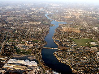
The St. Joseph River is a tributary of Lake Michigan with a length of 206 miles (332 km). The river flows in a generally westerly direction through southern Michigan and northern Indiana, United States, to its terminus on the southeast shore of the lake. It drains a primarily rural farming area in the watershed of Lake Michigan. It was enormously important to Native Americans and greatly aided in the colonial exploration, settlement and administration of New France and the nascent United States as a canoe route between Lake Michigan and the watershed of the Mississippi River.
The Lake Shore and Michigan Southern Railway, established in 1833, and sometimes referred to as the Lake Shore, was a major part of the New York Central Railroad's Water Level Route from Buffalo, New York, to Chicago, Illinois, primarily along the south shore of Lake Erie and across northern Indiana. The line's trackage remains a major rail transportation corridor used by Amtrak passenger trains and several freight lines; in 1998, its ownership was split at Cleveland, Ohio, between CSX Transportation to the east and Norfolk Southern Railway in the west.
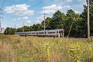
The South Shore Line is an electrically powered interurban commuter rail line operated by the Northern Indiana Commuter Transportation District (NICTD) between Millennium Station in downtown Chicago and the South Bend International Airport in South Bend, Indiana, United States. The name refers to both the physical line and the service operated over that route. The line was built in 1901–1908 by predecessors of the Chicago South Shore and South Bend Railroad, which continues to operate freight service. Passenger operation was assumed by the NICTD in 1989, who also purchased the track in 1990. The South Shore Line is one of the last surviving interurban trains in the United States. In 2023, the system had a ridership of 1,406,900, or about 5,000 per weekday as of the fourth quarter of 2023.
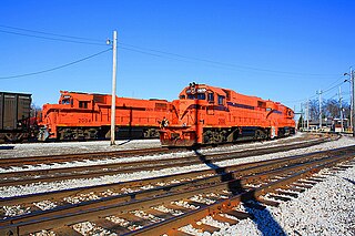
The Chicago South Shore and South Bend Railroad, also known as the South Shore Line, is a Class III freight railroad operating between Chicago, Illinois, and South Bend, Indiana. The railroad serves as a link between Class I railroads and local industries in northeast Illinois and northwest Indiana. It built the South Shore Line electric interurban and operated it until 1990, when the South Shore transferred its passenger operations to the Northern Indiana Commuter Transportation District. The freight railroad is owned by the Anacostia Rail Holdings Company.

Hegewisch is a commuter rail station in the city of Chicago, Illinois in the Hegewisch neighborhood, that serves the South Shore Line north to Millennium Station and east to the cities of Hammond, East Chicago, Gary, Michigan City, and South Bend, Indiana. The Hegewisch station has high-level platforms, as part of NICTD's continuing effort to comply with the Americans with Disabilities Act of 1990.
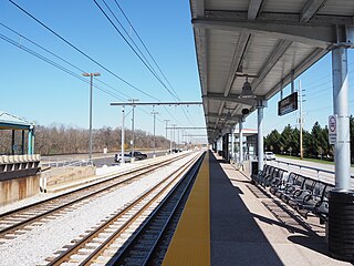
Dune Park is a station in Westchester Township, Porter County, Indiana, located north of the municipalities of Chesterton and Porter. It is used by South Shore Line trains, and serves as the headquarters of the Northern Indiana Commuter Transportation District (NICTD), the umbrella agency that operates the South Shore Line. It is located at the intersection of U.S. Highway 12 and Indiana State Road 49.
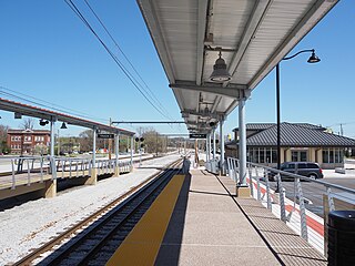
Portage/Ogden Dunes is a station in Porter County, Indiana serving the municipalities of Portage, Indiana and Ogden Dunes, Indiana. It is used by South Shore Line trains. Ogden Dunes is a semi-gated community with one major access road off of U.S. Highway 12, and the station is located adjacent to where this road accesses the community.
Miller is a train station in Gary, Indiana, serving the South Shore Line commuter rail system. It serves the community of Miller Beach and is one of three South Shore Line stations within the municipal boundaries of Gary.

Gary Metro Center is a multimodal commuter hub operated by the Gary Public Transportation Corporation. It was built in 1984 as an elevated replacement of the previously ground-level Broadway Street Station.
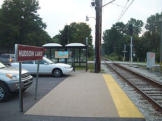
Hudson Lake is a train stop operated by the South Shore Line in the unincorporated community of Hudson Lake, Indiana. It is one of a very few interurban stations located in a rural region of the United States, being located approximately halfway between the much larger communities of Michigan City and South Bend. The station is composed of a passenger shelter, a sign, a small concrete pad, and a small parking lot.

The Kankakee Outwash Plain is a flat plain interspersed with sand dunes in the Kankakee River valley in northwestern Indiana and northeastern Illinois of the United States. It is just south of the Valparaiso Moraine and was formed during the Wisconsin Glaciation. As the glacier stopped at the Valparaiso Moraine, its meltwater was carried away to the outwash plain. On the south side of the moraine, where the elevation drops, the meltwaters eroded away valleys, carrying sand and mud with them. As the muddy meltwater reached the valley where the slope lessened, the water slowed, depositing the sand on the outwash plain. This created a smooth, flat, and sandy plain. Before its draining, the Kankakee Marsh, located on the outwash plain, was one of the largest freshwater marshes in the United States.

Ambridge Mann, sometimes called Ambridge-Horace Mann or Horace Mann-Ambridge, is a neighborhood in northwestern Gary, Indiana. It is bounded by the Grand Calumet River on the north, by Grant Street on the east, by Chase Street on the west, and by the Norfolk Southern railroad on the south. Adjacent areas include an industrial district to the north, Downtown West to the east, Tolleston to the south, and Brunswick to the west. As of 2000, Ambridge Mann had a population of 6,236, which was 96.3% African-American. Located just south of Interstate 90, the neighborhood can be seen while passing Buchanan Street.
New Carlisle was a South Shore Line flag stop located at the corner of Arch and Zigler Streets in New Carlisle, Indiana. The station opened circa 1908 and was built by the Chicago, South Bend and Northern Indiana Railway whose line was immediately north of the South Shore Line. Both lines used the station until the Northern Indiana Railway abandoned its South Bend–Michigan City line leaving the South Shore as the sole occupant. The station remained in service on the South Shore Line until July 5, 1994, when it was closed as part of an NICTD service revision which also saw the closure of Ambridge, Kemil Road, Willard Avenue, LaLumiere, and Rolling Prairie.
LaLumiere was a South Shore Line flag stop located at Wilhelm Road in LaPorte County, Indiana. The station opened prior to 1910 and closed on July 5, 1994, as part of an NICTD service revision which also saw the closure of Ambridge, Kemil Road, Willard Avenue, Rolling Prairie, and New Carlisle.
Willard Avenue was a South Shore Line flag stop located at the corner of Willard Avenue and 10th Street in Michigan City, Indiana. The station opened prior to 1937 and closed on July 5, 1994, as part of an NICTD service revision which also saw the closure of Ambridge, Kemil Road, LaLumiere, Rolling Prairie, and New Carlisle.
Dune Acres was a South Shore Line flag stop located at Mineral Springs Road serving Dune Acres in Porter County, Indiana. The station opened prior to 1910 and closed in 1994, as part of an NICTD service revision which also saw the closure of Ambridge, Kemil Road, Willard Avenue, LaLumiere, Rolling Prairie, and New Carlisle. The station did not close on July 5, 1994, like the other stations, instead closing after parking was expanded at the Dune Park station.
Rolling Prairie was a South Shore Line flag stop located at County Road 500 East which served the communities of Rolling Prairie and Birchim in LaPorte County, Indiana. The station opened prior to 1910, and closed on July 5, 1994, as part of an NICTD service revision which also saw the closure of Ambridge, Kemil Road, Willard Avenue, LaLumiere, and New Carlisle.
Kemil Road was a South Shore Line flag stop located at the corner of Kemil Road and U.S. 12 in Porter County, Indiana. The stop was located at the eastern edge of the Indiana Dunes State Park. It was established in 1977 on the initiative of South Shore Recreation, a citizens group, and closed in 1994.

Tremont was a flag stop on the South Shore Line located at Tremont Road in Porter County, Indiana. The station was built by the Chicago, Lake Shore and South Bend Railway and opened circa 1908, serving its namesake town and later the Indiana Dunes.
