Analogue modelling (geology)

Last updated
Pure shear sandbox model of thrust fault formation Geological bodies modelling.jpg
Pure shear sandbox model of thrust fault formation

Analogue modelling is a laboratory experimental method using uncomplicated physical models (such as a sandbox) with certain simple scales of time and length to model geological scenarios and simulate geodynamic evolutions. [1] [2]

Contents

There are numerous limitations affecting the direct study of the Earth. Firstly, the timescales of geodynamic processes are exceptionally long (millions of years), and most of the processes started long before human records. [1] [3] Secondly, the length scales of geodynamic processes are enormous (thousands of kilometres), and most of them happen at depth within the Earth. [1] [3] Thus, scientists began making proportional small-scale simulations of features in the natural world to test geological ideas. Analogue models can directly show the whole structural pattern in 3D and cross-section. They are helpful in understanding the internal structures and the progressive development of Earth's deforming regions. [1]

Analogue modelling has been widely used for geodynamic analysis and to illustrate the development of different geological phenomena. Models can explore small-scale processes, such as folding and faulting, or large-scale processes, such as tectonic movement and interior Earth structures. [1] [4]

History

Lateral compression machine made by James Hall to model geological folding. This machine is still present in the Royal Society of Edinburgh. The materials squeezed in the box are blankets or layers of clay. First Analogue Modelling of Folding by Sir James Hall in 1815 (update).gif
Lateral compression machine made by James Hall to model geological folding. This machine is still present in the Royal Society of Edinburgh. The materials squeezed in the box are blankets or layers of clay.

Analogue modelling has a development history of over 200 years. [1]

It has been used since at least 1812, when James Hall squeezed layers of clay to produce folds similar to those that he had studied at an outcrop. [2] This idea of modelling led to many other small-scale studies, such as fault-propagation fold, [5] thrust fault, [6] and folds [7] in the late 19th century. These studies were all qualitative. [1]

King Hubbert came up with the theory of scaling in 1937, meaning that the study of analogue modelling became quantitative. [8] The quantitative approach was further developed by many scientists later. [1] As the field of geodynamic study expanded, analogue modelling increased, especially for large-scale geological processes. Examples include proto-subduction [9] subduction [10] [11] in plate tectonics, collision, [12] diapirism, [13] and rifting. [14] [1] [4]

Components

Analogue model of caldera formation using flour to represent the upper part of the crust and a balloon to represent the inflating magma chamber Origin of volcanic caldera via analogue model.gif
Analogue model of caldera formation using flour to represent the upper part of the crust and a balloon to represent the inflating magma chamber

Scaling

In 1937 King Hubbert described the key principles for scaling analogue models. He defined three types of similarity between models and the natural world: geometric, kinematic and dynamic. [8] [15]

Geometric similarity

To be geometrically similar, lengths in the model and natural example must be proportional and angles must be equal. [15] When the length of a natural prototype (p) is (n=1, 2, 3...) and the angle is . Correspondingly, the length in the model (m) is and the angle is . They need to conform to the following formulas: [1]

&

For example, 1 centimetre in the model represents 1 kilometre in nature.

Kinematic similarity

To be kinematically similar, they must be geometrically similar and the time needed for changes to occur must be proportional. [9] When the required time for changing is : [1]

For example, 1 second in the model represents 1 thousand years in the nature.

As is known: , the velocities () can be scaled by the following equation: [1]

Dynamic similarity

When the models and the natural world are geometrically and kinematically similar, dynamic similarity additionally requires that the various forces acting on a point in the model are proportional to those at a corresponding point in nature. [15] When the forces () acting on the system are (gravity), (viscous force), and (friction): [15]

However, since the forces acting in the nature are unmeasurable, it is impossible to scale the forces and stresses directly. Scientists have been using different formulas to convert forces into the parameters that can be measured. Cauchy momentum equation is usually used for showing the relationship between forces and densities ( is density): [1]

(Generating from Cauchy momentum equation [16] )

Stokes' law is usually used for showing the relationship between forces and density contrasts ( is density constant): [1]

(Generating from Stokes' law [17] )

(While the gravitational acceleration )

Since the densities and density contrasts are proportional to forces and stresses, it is easy to scale densities or density contrasts instead of scaling forces and stresses. [1]

However, these two equations can lead to different topography scales. [1]

The simple analogue modelling of the fold-thrust belt system taken in the Nanjing University physical laboratory. The white and blue materials are quartz sands. Analogue modelling of fold-thrust belt system.gif
The simple analogue modelling of the fold-thrust belt system taken in the Nanjing University physical laboratory. The white and blue materials are quartz sands.

Experimental apparatus

Different geodynamic processes are simulated by different experimental apparatus.

For example, lateral compression machines are commonly used in simulating deformations involving lithospheric shortening, such as folding, [2] thrust faulting, collision, and subduction. Longitudinal compression machines are usually used for fracturing. [18] There is a large variety of devices based on the different sources of forces applied to the material. Some devices have multiple forcing systems because nature is not homogeneous. [1]

Lab environment

Systems

For experimental systems, the energy can be supplied externally (at the boundary) and internally (buoyancy forces). If the deformation is only caused by internal forces, it is a closed system. Conversely, if the deformations are caused by external forces or a combination of internal and external forces, it is an open system. [1]

For the open system, the extrusion or stretching forces are imposed externally. However, the buoyancy forces can be generated both externally or internally. The materials and thermal energy can be added to or remove from the system. For the closed system, there is no energy and materials added to the system. Thus, all the deformations are caused by internal buoyancy forces. Only buoyancy-driven deformation can be simulated in a closed system. [1]

Gravity field

The simple analogue modelling of a subduction zone. The materials this model uses are sand mixture and silicone putty for the continental crust (left in layered brown) and oceanic crust (right in layered brown), and glucose syrup for the asthenosphere (greenish-blue liquid in the glass tank). There is a heater in the tank for heating the liquid. Analogue Modelling of a Subduction Zone (update).gif
The simple analogue modelling of a subduction zone. The materials this model uses are sand mixture and silicone putty for the continental crust (left in layered brown) and oceanic crust (right in layered brown), and glucose syrup for the asthenosphere (greenish-blue liquid in the glass tank). There is a heater in the tank for heating the liquid.

Because the major research object of analogue modelling is Earth, the gravity field that most experiments utilize is ordinarily the Earth's field of gravity. However, many models are carried out using simulated gravity, for example, by use of a centrifuge. These technologies are usually used in studying development of gravity-controlled structures, such as dome formation, [21] and diapirism. [1]

Materials

Analogue modelling uses various materials, such as sand, clay, silicone and paraffin wax. [2] Different materials came into use for quantitative analysis of analogue modelling experiments, compared to qualitative analysis. [22] Before Hubbert's scaling theory, scientists used natural materials (e.g. clays, soil, and sand) for analogue modelling. [1] For large-scale simulation, analogue modelling should have geometric, kinematic, and dynamic similarity with nature. If the model has these similarities, results from simulation will be more accurate. [8] All these different materials represent the natural features of Earth (such as crust, mantle, and river). [22] Selection of analogue materials is difficult, because of the largely rheology-dependent deformation and inconstant rheology influenced by the thermal gradient in nature. The rheological characteristic of internal layering was developed by the study of seismology and geochemistry. [1]

To simulate layers with different properties, different materials are chosen:

Materials for analogue modelling [1]
CategoriesExamplesSimulation
Granular materials (various in density, shape, and size)Quartz sand, glass microbeads, feldspar powderBrittle upper crust [8]
Low-viscous materialsWater, sugar solution, honey Asthenosphere,

Sub-lithospheric mantle

Corn syrup, glucose syrup Sinking slabs [23]
High linear viscous materialsSyrup, silicone puttyDuctile lithosphere
Visco-elastic materialsAmorphous polymers, biopolymers, bitumen
Non-linear viscous materialsPlastic materials Plasticine
Visco-plastic materials Wax, paraffin
Visco-elasto-plastic materials Gelatin

Advantages

There are many useful properties of analogue modelling:

  1. Analogue models can directly show whole geodynamic processes from start to finish. [1]
  2. Geodynamic processes can be stopped at any time for investigation, and allow the study of 3D structures. [24]
  3. The scales of the model can be controlled in a practicable range for the laboratory. [1]
  4. The simulation can show different results of geodynamic processes by altering the parameters, and the influence of each parameter is clarified. [24]
  5. The results of analogue modelling can be directly used for interpreting nature if the accuracy of the model is high. [1]
  6. Analogue modelling can provide new ways of thinking about geological problems. [24]

Disadvantages

Because analogue modelling involves the simplification of geodynamic processes, it also has several disadvantages and limitations: [15]

  1. The study of natural rock properties still needs more research. The more accurate the input data, the more accurate the analogue modelling. [15]
  2. There are many more factors in nature that affect the geodynamic processes (such as isostatic compensation and erosion), and these are most likely heterogeneous systems. Thus they are challenging for simulations (some factors are not even known).
  3. The variation of natural rocks is greater than in simulated materials; therefore it is difficult to fully model the real situation. [15]
  4. Analogue modelling cannot simulate chemical reactions. [15]
  5. There are systematic errors in the apparatus, and random errors due to human factors. [1]

Applications

Simple analogue modelling of the growth and erosion of an orogenic wedge. This simulation is done in a glass tank, with layered different granular materials that represent the crust. Analogue Modelling of the Growth and erosion of an orogenic wedge (update).gif
Simple analogue modelling of the growth and erosion of an orogenic wedge. This simulation is done in a glass tank, with layered different granular materials that represent the crust.

Analogue modelling can be used to simulate different geodynamic processes and geological phenomena, such as small-scale problems folding, fracturing, boudinage and shear zone, and large-scale problems subduction, collision, diapirism, and mantle convection. [1] [4] The following are some examples of applications of analogue modelling.

Compressional tectonics

The first analogue model was built by James Hall for simulating folds. He used a lateral compression machine for the simulation, and this machine is still shown in the Royal Society of Edinburgh. [2] The final result from the model is quite close to observation of the Berwickshire coast. [2] Although the model he used is simpler than current ones, the idea remains in use.

The use of more complex compression machines substantially increases the number of simulations of compressional tectonics, including subduction, collision, lithospheric shortening, fracture formation, thrust and accretionary wedge. If the simulation only focuses on the upper crustal, the model is always built in the glass box (or two lateral glass walls) with a piston and/or wedges to supply forces to layers of granular materials (normally called sandbox). Depending on the different natural features, erosion (removal of top materials at a certain angle), décollement (inserted layers with low cohesion, normally glass microbeads), and any other parameters can put into the model, producing various results. [25]

Simulations of mantle influences vary. Because of the different physical and chemical properties between the asthenosphere and lithosphere, viscous materials and a heater (for mantle convection) are also used. [2]

The simple analogue modelling of the extension tectonics which showing the formation of normal fault and salt dome (diapirism). This model is built in a glass box. The darker greyish layer is silicone which represents salt, and brownish layers are dry quartz sands which represent the brittle sedimentary rocks. Analogue Model of extension tectonics, forming of Normal Fault and Diapirs (salt dome) (update).gif
The simple analogue modelling of the extension tectonics which showing the formation of normal fault and salt dome (diapirism). This model is built in a glass box. The darker greyish layer is silicone which represents salt, and brownish layers are dry quartz sands which represent the brittle sedimentary rocks.

Extensional tectonics

Compression machines can also be used in reverse for simulating extensional tectonics, such as lithospheric extension, the formation of rifts, normal faulting, boudinage and diapirs. These models can also be built in a glass box which is similar to the above, but instead of thrust force, tensile force is applied. [13]

Strike-slip tectonics

The simplified analogue modelling setting of shear deformation. This model is built on two separate horizontal plates. The brownish layers are dry sand, wet clay, and viscous materials, such as silicone or polydimethylsiloxane. Experimental Set-up of Shear Deformation Analogue Modelling (update).png
The simplified analogue modelling setting of shear deformation. This model is built on two separate horizontal plates. The brownish layers are dry sand, wet clay, and viscous materials, such as silicone or polydimethylsiloxane.

Strike-slip tectonics differ from the dominantly vertical crust movements associated with shortening and extension, being dominantly horizontal in character (in relative terms sinistral or dextral). This kind of horizontal movement will create a shear zone and several types of fractures and faults. A typical model used for strike-slip tectonics has two (or more) horizontal basal plates moving in opposite directions (or only move one of the plates, other are fixed). The visual results are shown from bird's-eye view. Scientists used CT-analysis to collect the cross-section images for the observation of the most influenced area during the simulation. [26]

See also

Related Research Articles

<span class="mw-page-title-main">Plate tectonics</span> Movement of Earths lithosphere

Plate tectonics is the scientific theory that Earth's lithosphere comprises a number of large tectonic plates, which have been slowly moving since about 3.4 billion years ago. The model builds on the concept of continental drift, an idea developed during the first decades of the 20th century. Plate tectonics came to be accepted by geoscientists after seafloor spreading was validated in the mid-to-late 1960s.

<span class="mw-page-title-main">Structural geology</span> Science of the description and interpretation of deformation in the Earths crust

Structural geology is the study of the three-dimensional distribution of rock units with respect to their deformational histories. The primary goal of structural geology is to use measurements of present-day rock geometries to uncover information about the history of deformation (strain) in the rocks, and ultimately, to understand the stress field that resulted in the observed strain and geometries. This understanding of the dynamics of the stress field can be linked to important events in the geologic past; a common goal is to understand the structural evolution of a particular area with respect to regionally widespread patterns of rock deformation due to plate tectonics.

<span class="mw-page-title-main">Seafloor spreading</span> Geological process at mid-ocean ridges

Seafloor spreading, or seafloor spread, is a process that occurs at mid-ocean ridges, where new oceanic crust is formed through volcanic activity and then gradually moves away from the ridge.

<span class="mw-page-title-main">Subduction</span> A geological process at convergent tectonic plate boundaries where one plate moves under the other

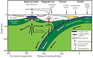
Subduction is a geological process in which the oceanic lithosphere and some continental lithosphere is recycled into the Earth's mantle at convergent boundaries. Where the oceanic lithosphere of a tectonic plate converges with the less dense lithosphere of a second plate, the heavier plate dives beneath the second plate and sinks into the mantle. A region where this process occurs is known as a subduction zone, and its surface expression is known as an arc-trench complex. The process of subduction has created most of the Earth's continental crust. Rates of subduction are typically measured in centimeters per year, with rates of convergence as high as 11 cm/year.

Tectonophysics, a branch of geophysics, is the study of the physical processes that underlie tectonic deformation. This includes measurement or calculation of the stress- and strain fields on Earth’s surface and the rheologies of the crust, mantle, lithosphere and asthenosphere.

<span class="mw-page-title-main">Mantle convection</span> Gradual movement of the planets mantle

Mantle convection is the very slow creep of Earth's solid silicate mantle as convection currents carry heat from the interior to the planet's surface. Mantle convection causes tectonic plates to move around the Earth's surface.

<span class="mw-page-title-main">North China Craton</span> Continental crustal block in northeast China, Inner Mongolia, the Yellow Sea, and North Korea

The North China Craton is a continental crustal block with one of Earth's most complete and complex records of igneous, sedimentary and metamorphic processes. It is located in northeast China, Inner Mongolia, the Yellow Sea, and North Korea. The term craton designates this as a piece of continent that is stable, buoyant and rigid. Basic properties of the cratonic crust include being thick, relatively cold when compared to other regions, and low density. The North China Craton is an ancient craton, which experienced a long period of stability and fitted the definition of a craton well. However, the North China Craton later experienced destruction of some of its deeper parts (decratonization), which means that this piece of continent is no longer as stable.

<span class="mw-page-title-main">Geodynamics</span> Study of dynamics of the Earth

}} Geodynamics is a subfield of geophysics dealing with dynamics of the Earth. It applies physics, chemistry and mathematics to the understanding of how mantle convection leads to plate tectonics and geologic phenomena such as seafloor spreading, mountain building, volcanoes, earthquakes, faulting. It also attempts to probe the internal activity by measuring magnetic fields, gravity, and seismic waves, as well as the mineralogy of rocks and their isotopic composition. Methods of geodynamics are also applied to exploration of other planets.

<span class="mw-page-title-main">Slab (geology)</span> The portion of a tectonic plate that is being subducted

In geology, the slab is a significant constituent of subduction zones.

Ultra-high-pressure metamorphism refers to metamorphic processes at pressures high enough to stabilize coesite, the high-pressure polymorph of SiO2. It is important because the processes that form and exhume ultra-high-pressure (UHP) metamorphic rocks may strongly affect plate tectonics, the composition and evolution of Earth's crust. The discovery of UHP metamorphic rocks in 1984 revolutionized our understanding of plate tectonics. Prior to 1984 there was little suspicion that continental rocks could reach such high pressures.

<span class="mw-page-title-main">High pressure metamorphic terranes along the Bangong-Nujiang Suture Zone</span>

High pressure terranes along the ~1200 km long east-west trending Bangong-Nujiang suture zone (BNS) on the Tibetan Plateau have been extensively mapped and studied. Understanding the geodynamic processes in which these terranes are created is key to understanding the development and subsequent deformation of the BNS and Eurasian deformation as a whole.

Mountains are widely distributed across the surface of Io, the innermost large moon of Jupiter. There are about 115 named mountains; the average length is 157 km (98 mi) and the average height is 6,300 m (20,700 ft). The longest is 570 km (350 mi), and the highest is Boösaule Montes, at 17,500 metres (57,400 ft), taller than any mountain on Earth. Ionian mountains often appear as large, isolated structures; no global tectonic pattern is evident, unlike on Earth, where plate tectonics is dominant.

<span class="mw-page-title-main">Geodynamics of terrestrial exoplanets</span>

The discovery of extrasolar Earth-sized planets has encouraged research into their potential for habitability. One of the generally agreed requirements for a life-sustaining planet is a mobile, fractured lithosphere cyclically recycled into a vigorously convecting mantle, in a process commonly known as plate tectonics. Plate tectonics provide a means of geochemical regulation of atmospheric particulates, as well as removal of carbon from the atmosphere. This prevents a “runaway greenhouse” effect that can result in inhospitable surface temperatures and vaporization of liquid surface water. Planetary scientists have not reached a consensus on whether Earth-like exoplanets have plate tectonics, but it is widely thought that the likelihood of plate tectonics on an Earth-like exoplanet is a function of planetary radius, initial temperature upon coalescence, insolation, and presence or absence of liquid-phase surface water.

<span class="mw-page-title-main">Numerical modeling (geology)</span> Technique to solve geological problems by computational simulation

In geology, numerical modeling is a widely applied technique to tackle complex geological problems by computational simulation of geological scenarios.

<span class="mw-page-title-main">Salt deformation</span> Change of shape of geological salt bodies submitted to stress

Salt deformation is the change of shape of natural salt bodies in response to forces and mechanisms that controls salt flow. Such deformation can generate large salt structures such as underground salt layers, salt diapirs or salt sheets at the surface. Strictly speaking, salt structures are formed by rock salt that is composed of pure halite (NaCl) crystal. However, most halite in nature appears in impure form, therefore rock salt usually refers to all rocks that composed mainly of halite, sometimes also as a mixture with other evaporites such as gypsum and anhydrite. Earth's salt deformation generally involves such mixed materials.

This is a compilation of the properties of different analog materials used to simulate deformational processes in structural geology. Such experiments are often called analog or analogue models. The organization of this page follows the review of rock analog materials in structural geology and tectonics of Reber et al. 2020.

The Superior Craton is a stable crustal block covering Quebec, Ontario, and southeast Manitoba in Canada, and northern Minnesota in the United States. It is the biggest craton among those formed during the Archean period. A craton is a large part of the Earth's crust that has been stable and subjected to very little geological changes over a long time. The size of Superior Craton is about 1,572,000 km2. The craton underwent a series of events from 4.3 to 2.57 Ga. These events included the growth, drifting and deformation of both oceanic and continental crusts.

<span class="mw-page-title-main">Oblique subduction</span> Tectonic process

Oblique subduction is a form of subduction for which the convergence direction differs from 90° to the plate boundary. Most convergent boundaries involve oblique subduction, particularly in the Ring of Fire including the Ryukyu, Aleutian, Central America and Chile subduction zones. In general, the obliquity angle is between 15° and 30°. Subduction zones with high obliquity angles include Sunda trench and Ryukyu arc.

<span class="mw-page-title-main">Volcanic and igneous plumbing systems</span> Magma chambers

Volcanic and igneous plumbing systems (VIPS) consist of interconnected magma channels and chambers through which magma flows and is stored within Earth's crust. Volcanic plumbing systems can be found in all active tectonic settings, such as mid-oceanic ridges, subduction zones, and mantle plumes, when magmas generated in continental lithosphere, oceanic lithosphere, and in the sub-lithospheric mantle are transported. Magma is first generated by partial melting, followed by segregation and extraction from the source rock to separate the melt from the solid. As magma propagates upwards, a self-organised network of magma channels develops, transporting the melt from lower crust to upper regions. Channelled ascent mechanisms include the formation of dykes and ductile fractures that transport the melt in conduits. For bulk transportation, diapirs carry a large volume of melt and ascent through the crust. When magma stops ascending, or when magma supply stops, magma emplacement occurs. Different mechanisms of emplacement result in different structures, including plutons, sills, laccoliths and lopoliths.

Susan Marian Ellis is a geophysicist based in New Zealand, who specialises in modelling the geodynamics of the Earth's crust deformation, at different scales. Ellis is a principal scientist at GNS Science and her main interests are in subduction, seismology, tectonics, crust and petrology. Ellis's current work focuses on the influence of faulting on stresses in the crust, and how this is related to geological hazard and the tectonic settings in New Zealand.

References

  1. 1 2 3 4 5 6 7 8 9 10 11 12 13 14 15 16 17 18 19 20 21 22 23 24 25 26 27 28 Schellart, Wouter P.; Strak, Vincent (2016). "A review of analogue modelling of geodynamic processes: Approaches, scaling, materials and quantification, with an application to subduction experiments". Journal of Geodynamics. 100: 7–32. Bibcode:2016JGeo..100....7S. doi: 10.1016/j.jog.2016.03.009 . ISSN   0264-3707.
  2. 1 2 3 4 5 6 7 8 9 Ranalli, Giorgio (2001). "Experimental tectonics: from Sir James Hall to the present". Journal of Geodynamics. 32 (1–2): 65–76. Bibcode:2001JGeo...32...65R. doi:10.1016/s0264-3707(01)00023-0. ISSN   0264-3707.
  3. 1 2 Schreurs, Guido; Buiter, Susanne J. H. (Susanne Janita Henriët) (2006). Analogue and numerical modelling of crustal-scale processes. Geological Society. ISBN   978-1862391918. OCLC   191801955.
  4. 1 2 3 Strak, Vincent; Schellart, Wouter P. (2016). "Introduction to the special issue celebrating 200 years of geodynamic modelling". Journal of Geodynamics. 100: 1–6. Bibcode:2016JGeo..100....1S. doi:10.1016/j.jog.2016.08.003. ISSN   0264-3707.
  5. Hall, Sir James. "Geological Studies in the Pays-D'Enhaut Vaudois".{{cite journal}}: Cite journal requires |journal= (help)
  6. Cadell, Henry M. (1889). "VII.—Experimental Researches in Mountain Building". Earth and Environmental Science Transactions of the Royal Society of Edinburgh. 35 (1): 337–357. doi:10.1017/S0080456800017658. ISSN   2053-5945. S2CID   130985350.
  7. Bailey Willis (1894). The Mechanics of Appalachian Structure. Harvard University. Govt. print. off.
  8. 1 2 3 4 HUBBERT, M. K. (1937-10-01). "Theory of scale models as applied to the study of geologic structures". Geological Society of America Bulletin. 48 (10): 1459–1520. Bibcode:1937GSAB...48.1459H. doi:10.1130/gsab-48-1459. ISSN   0016-7606.
  9. 1 2 Ph.H., Kuenen (1937). The negative isostatic anomalies in the East Indies (with Experiments). OCLC   945425263.
  10. JACOBY, WOLFGANG R. (1973). "Model Experiment of Plate Movements". Nature Physical Science. 242 (122): 130–134. Bibcode:1973NPhS..242..130J. doi:10.1038/physci242130a0. ISSN   0300-8746.
  11. Kincaid, Chris; Olson, Peter (1987-12-10). "An experimental study of subduction and slab migration". Journal of Geophysical Research: Solid Earth. 92 (B13): 13832–13840. Bibcode:1987JGR....9213832K. doi:10.1029/jb092ib13p13832. ISSN   0148-0227.
  12. Tapponnier, P.; Peltzer, G.; Le Dain, A. Y.; Armijo, R.; Cobbold, P. (1982). "Propagating extrusion tectonics in Asia: New insights from simple experiments with plasticine". Geology. 10 (12): 611. Bibcode:1982Geo....10..611T. doi:10.1130/0091-7613(1982)10<611:petian>2.0.co;2. ISSN   0091-7613.
  13. 1 2 3 Vendeville, B.C.; Jackson, M.P.A. (1992-01-01). "The Rise and Fall of Diapirs During Thin-Skinned Extension". Report Investigation. doi:10.23867/ri0209d. ISSN   2475-367X.
  14. Brune, James N.; Ellis, Michael A. (1997-05-01). "Structural features in a brittle–ductile wax model of continental extension". Nature. 387 (6628): 67–70. Bibcode:1997Natur.387...67B. doi:10.1038/387067a0. ISSN   0028-0836. S2CID   4358229.
  15. 1 2 3 4 5 6 7 8 Koyi, H. (2007-12-18). "Analogue modelling: From a qualitative to a quantitative technique — A historical outline". Journal of Petroleum Geology. 20 (2): 223–238. Bibcode:1997JPetG..20..223K. doi:10.1111/j.1747-5457.1997.tb00774.x. ISSN   0141-6421. S2CID   128619258.
  16. Davy, Ph.; Cobbold, P.R. (1991-03-10). "Experiments on shortening of a 4-layer model of the continental lithosphere". Tectonophysics. 188 (1–2): 1–25. Bibcode:1991Tectp.188....1D. doi:10.1016/0040-1951(91)90311-f. ISSN   0040-1951.
  17. JACOBY, WOLFGANG R. (1973). "Model Experiment of Plate Movements". Nature Physical Science. 242 (122): 130–134. Bibcode:1973NPhS..242..130J. doi:10.1038/physci242130a0. ISSN   0300-8746.
  18. Mead, Warren J. (1920). "Notes on the Mechanics of Geologic Structures". The Journal of Geology. 28 (6): 505–523. Bibcode:1920JG.....28..505M. doi: 10.1086/622731 . JSTOR   30063760.
  19. Shemenda, Alexander I. (1994). Subduction: Insights from Physical Modeling. Modern Approaches in Geophysics. Vol. 11. doi:10.1007/978-94-011-0952-9. ISBN   978-94-010-4411-0. ISSN   0924-6096.
  20. Rossetti, Federico; Ranalli, Giorgio; Faccenna, Claudio (1999). "Rheological properties of paraffin as an analogue material for viscous crustal deformation". Journal of Structural Geology. 21 (4): 413–417. Bibcode:1999JSG....21..413R. doi:10.1016/s0191-8141(99)00040-1. ISSN   0191-8141.
  21. Ramberg, H. (2010-01-26). "Model Experimentation of the Effect of Gravity on Tectonic Processes". Geophysical Journal of the Royal Astronomical Society. 14 (1–4): 307–329. doi: 10.1111/j.1365-246x.1967.tb06247.x . ISSN   0016-8009.
  22. 1 2 Klinkmüller, M.; Schreurs, G.; Rosenau, M.; Kemnitz, H. (2016-08-02). "Properties of granular analogue model materials: A community wide survey". Tectonophysics. 684: 23–38. Bibcode:2016Tectp.684...23K. doi:10.1016/j.tecto.2016.01.017. ISSN   0040-1951.
  23. Griffiths, Ross W.; Hackney, Ronald I.; van der Hilst, Rob D. (1995). "A laboratory investigation of effects of trench migration on the descent of subducted slabs". Earth and Planetary Science Letters. 133 (1–2): 1–17. Bibcode:1995E&PSL.133....1G. doi:10.1016/0012-821x(95)00027-a. hdl: 1874/7889 . ISSN   0012-821X. S2CID   128693911.
  24. 1 2 3 Gelder, Inge. "Analogue Modelling".
  25. Konstantinovskaia, Elena; Malavieille, Jacques (2005-02-26). "Erosion and exhumation in accretionary orogens: Experimental and geological approaches" (PDF). Geochemistry, Geophysics, Geosystems. 6 (2): Q02006. Bibcode:2005GGG.....6.2006K. doi:10.1029/2004gc000794. ISSN   1525-2027. S2CID   128854343.
  26. 1 2 Dooley, Tim P.; Schreurs, Guido (2012-10-29). "Analogue modelling of intraplate strike-slip tectonics: A review and new experimental results". Tectonophysics. 574–575: 1–71. Bibcode:2012Tectp.574....1D. doi:10.1016/j.tecto.2012.05.030. ISSN   0040-1951.