North Carolina is a state in the Southeastern region of the United States. The state is the 28th largest and 9th-most populous of the United States. It is bordered by Virginia to the north, the Atlantic Ocean to the east, Georgia and South Carolina to the south, and Tennessee to the west. In the 2020 census, the state had a population of 10,439,388. Raleigh is the state's capital and Charlotte is its largest city. The Charlotte metropolitan area, with a population of 2,595,027 in 2020, is the most-populous metropolitan area in North Carolina, the 21st-most populous in the United States, and the largest banking center in the nation after New York City. The Raleigh-Durham-Cary combined statistical area is the second-largest metropolitan area in the state and 32nd-most populous in the United States, with a population of 2,043,867 in 2020, and is home to the largest research park in the United States, Research Triangle Park.

South Carolina is a state in the coastal Southeastern region of the United States. It is bordered to the north by North Carolina, to the southeast by the Atlantic Ocean, and to the southwest by Georgia across the Savannah River. South Carolina is the 40th most extensive and 23rd most populous U.S. state with a recorded population of 5,124,712 according to the 2020 census. In 2019, its GDP was $213.45 billion. South Carolina is composed of 46 counties. The capital is Columbia with a population of 137,300 in 2020; while its largest city is Charleston with a 2020 population of 150,277. The Greenville–Spartanburg-Anderson metropolitan area is the most populous in the state, with a 2020 population estimate of 1,455,892.

Wilson County is a county located in the U.S. state of North Carolina. As of the 2020 census, the population was 78,784. The county seat is Wilson. The county comprises the Wilson Micropolitan Statistical Area, which is also included within the Rocky Mount–Wilson–Roanoke Rapids Combined Statistical Area.

Washington County is a county located in the U.S. state of North Carolina. As of the 2020 census, the population was 11,003. Its county seat is Plymouth. The county was formed in 1799 from the western third of Tyrrell County. It was named for George Washington.

Warren County is a county located in the northeastern Piedmont region of the U.S. state of North Carolina, on the northern border with Virginia, made famous for a landfill and birthplace of the environmental justice movement. As of the 2020 census, its population was 18,642. Its county seat is Warrenton. It was a center of tobacco and cotton plantations, education, and later textile mills.

Tyrrell County is a county located in the U.S. state of North Carolina. As of the 2020 census, the population was 3,245, making it the least populous county in North Carolina. Its county seat is Columbia. The county was created in 1729 as Tyrrell Precinct and gained county status in 1739. Tyrrell County is included in the Kill Devil Hills, NC, Micropolitan Statistical Area, which is also included in the Virginia Beach-Norfolk, VA-NC Combined Statistical Area.

Perquimans County is a county located in the U.S. state of North Carolina. As of the 2020 census, the population was 13,005. Its county seat is Hertford. The county was originally created as Berkeley Precinct. It was renamed Perquimans Precinct around 1684 and gained county status in 1739. Perquimans County is part of the Elizabeth City, NC Micropolitan Statistical Area, which is also included in the Virginia Beach-Norfolk, VA-NC Combined Statistical Area. The Harvey Point Defense Testing Activity facility is located in Perquimans County.

Pender County is a county located in the U.S. state of North Carolina. As of the 2020 census, the population was 60,203. Its county seat is Burgaw. Pender County is part of the Wilmington, NC Metropolitan Statistical Area.

Pasquotank County is a county located in the U.S. state of North Carolina. As of the 2020 census, the population was 40,568. Its county seat is Elizabeth City. The county was originally created as Pasquotank Precinct and gained county status in 1739. Pasquotank County is part of the Elizabeth City, NC Micropolitan Statistical Area, which is also included in the Virginia Beach-Norfolk, VA-NC Combined Statistical Area.

Hyde County is a county located in the U.S. state of North Carolina. As of the 2020 census, the population was 4,589, making it the second-least populous county in North Carolina. Its county seat is Swan Quarter. The county was created in 1705 as Wickham Precinct. It was renamed Hyde Precinct in 1712 and gained county status in 1739.

Davie County is a county located in the U.S. state of North Carolina. As of the 2020 census, the population was 42,712. Its county seat is Mocksville.

Chowan County is one of the 100 counties located in the U.S. state of North Carolina. As of the 2020 census, the population was 13,708. Its county seat is Edenton. The county was created between 1668 and 1671 as Shaftesbury Precinct and later renamed Chowan Precinct. It gained county status in 1739.

Camden County is a consolidated city-county located in the U.S. State of North Carolina. As of the 2020 census, the population was 10,335, making it the fourth-least populous county in North Carolina. Its county seat is Camden. Camden County is part of the Elizabeth City, NC Micropolitan Statistical Area, which is also included in the Virginia Beach-Norfolk, VA-NC Combined Statistical Area.

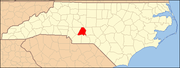
Anson County is a county located in the U.S. state of North Carolina. As of the 2020 census, the population was 22,055. Its county seat is Wadesboro.

Harrisburg, a northeastern suburb of Charlotte, is a city in Cabarrus County, North Carolina, United States. The population was estimated to be 16,576 as of 1 July 2019.

North Myrtle Beach is a city in Horry County, South Carolina, United States. It was created in 1968 from four existing municipalities, and is located about 15 miles (24 km) northeast of Myrtle Beach. It serves as one of the primary tourist destinations along the Grand Strand. As of the 2010 census, the population was 13,752, and in 2019 the estimated population was 16,819. It is part of the Myrtle Beach-Conway-North Myrtle Beach, SC Metropolitan Statistical Area, which had a combined population of 449,295 as of 2016.

The Southeastern United States, also referred to as the American Southeast, the Southeast, or simply the South, is a geographical region of the United States. It is located broadly on the eastern portion of the Southern United States and the southern portion of the Eastern United States. It comprises at least a core of states on the lower East Coast of the United States and eastern Gulf Coast. Expansively, it reaches as far north as West Virginia and Maryland, which borders the Ohio River and Mason–Dixon line, and stretches as far west as Arkansas and Louisiana. There is no official U.S. government definition of the region, though various agencies and departments use different definitions.
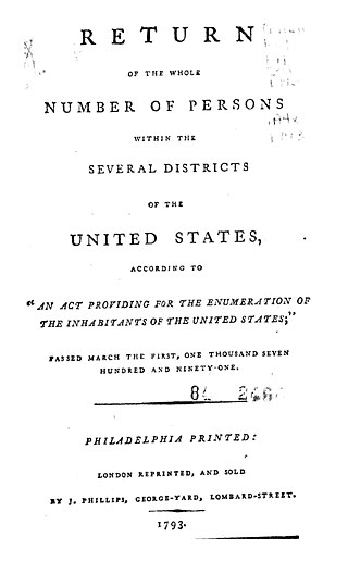
The 1790 United States census was the first United States census. It recorded the population of the whole United States as of Census Day, August 2, 1790, as mandated by Article 1, Section 2, of the Constitution and applicable laws. In the first census, the population of the United States was enumerated to be 3,929,214 inhabitants.
Demographics of North Carolina covers the varieties of ethnic groups who reside in North Carolina and relevant trends.

North Carolina Highway 138 (NC 138) is a primary state highway in the U.S. state of North Carolina. It serves to connect the community of Aquadale to nearby Oakboro and Albemarle.