Norwood, North Carolina

Last updated

Norwood, North Carolina
Town
Norwood, North Carolina.jpg
NCMap-doton-Norwood.PNG
Location of Norwood, North Carolina
Coordinates: 35°14′01″N80°06′52″W / 35.23361°N 80.11444°W / 35.23361; -80.11444
Country United States
State North Carolina
County Stanly
Area
[1]
  Total4.55 sq mi (11.78 km2)
  Land4.54 sq mi (11.75 km2)
  Water0.01 sq mi (0.03 km2)
Elevation
[2]
413 ft (126 m)
Population
 (2020)
  Total2,367
  Density521.60/sq mi (201.39/km2)
Time zone UTC-5 (Eastern (EST))
  Summer (DST) UTC-4 (EDT)
ZIP code
28128
Area code 704
FIPS code 37-47980 [3]
GNIS feature ID2407011 [2]
Website norwoodgov.com

Norwood is a town in Stanly County, North Carolina, United States. The population was 2,379 at the 2010 census.

Contents

Geography

According to the United States Census Bureau, the town has a total area of 2.4 square miles (6.2 km2), all land.

U.S. Route 52 passes through the town between Wadesboro and Albemarle.

Demographics

Historical population
CensusPop.Note
1890 159
1900 663317.0%
1910 92840.0%
1920 1,22131.6%
1930 1,45218.9%
1940 1,5154.3%
1950 1,73514.5%
1960 1,8446.3%
1970 1,8962.8%
1980 1,818−4.1%
1990 1,617−11.1%
2000 2,21637.0%
2010 2,3797.4%
2020 2,367−0.5%
U.S. Decennial Census [4]

2020 census

Norwood racial composition [5]
RaceNumberPercentage
White (non-Hispanic)1,67270.34%
Black or African American (non-Hispanic)45819.35%
Native American 140.59%
Asian 10.1%
Other/Mixed 753.17%
Hispanic or Latino 1335.62%

As of the 2020 United States census, there were 2,367 people, 830 households, and 584 families residing in the town.

2000 census

As of the census [3] of 2000, there were 2,216 people, 893 households, and 624 families residing in the town. The population density was 925.1 inhabitants per square mile (357.2/km2). There were 1,036 housing units at an average density of 432.5 per square mile (167.0/km2). The racial makeup of the town was 67.69% White, 25.45% African American, 0.05% Native American, 1.04% Asian, 4.87% from other races, and 0.90% from two or more races. Hispanic or Latino of any race were 6.72% of the population.

There were 893 households, out of which 28.7% had children under the age of 18 living with them, 52.2% were married couples living together, 13.1% had a female householder with no husband present, and 30.1% were non-families. 26.4% of all households were made up of individuals, and 13.4% had someone living alone who was 65 years of age or older. The average household size was 2.48 and the average family size was 2.95.

In the town, the population was spread out, with 25.2% under the age of 18, 6.8% from 18 to 24, 26.6% from 25 to 44, 26.0% from 45 to 64, and 15.3% who were 65 years of age or older. The median age was 38 years. For every 100 females, there were 90.4 males. For every 100 females age 18 and over, there were 86.8 males. Of these males, Chase Burleson resides in the southeastern quadrant of the town.

The median income for a household in the town was $31,563, and the median income for a family was $37,460. Males had a median income of $29,922 versus $20,288 for females. The per capita income for the town was $15,117. About 14.7% of families and 16.8% of the population were below the poverty line, including 21.6% of those under age 18 and 18.3% of those age 65 or over. Peyton Hatley is just one of these many people living in poverty.

About

Norwood is currently served by two railroads, one US Highway, and one NC Route. Water and sewer service is provided by the town through their own water and sewer plant. A branch library and museum provide educational opportunities. Bordered by Lake Tillery and the Rocky River, recreation is abundant. Golf is available at Piney Point Golf Club.

Fork Stables is located approximately two miles south of town and a Michelin tire plant, which manufactures aircraft tires, is located in town.

Police and fire protection are provided by the town by full-time officers.

Norwood is nestled in an area between two rivers next to the Uwharrie Mountains. There are two town parks for relaxation, recreation and exercise. The Darrell Almond Community Park is on North Main Street. This park features a gazebo next to the central pond and the Skidmore House which is available for community use. The park also features two walking trails, picnic shelters, horseshoe pits, a shuffle board court and playground equipment. Picnic shelters and the Skidmore House can be reserved at Town Hall. Norwood Memorial Park, located between Turner and College streets, has athletic fields and a larger community building. The building can be reserved for a fee at Town Hall.

Norwood has recently adopted a comprehensive transportation plan, pedestrian plan, and land use plan. These plans will help the town grow in a meaningful way and provide more sidewalks and trails along with an overall plan for better roads and transportation. Several state bicycle trails pass through town and there are scenic by-ways along N.C. 24/27/73 and other highways.

Celebrations throughout the year include Arbor Day in April, Picnic in the Park in October, and the annual Christmas parade. The nearby Fork Stables host Outdoor Heritage Days and two weeks of equestrian cross country, dressage, and show jumping competitions.

Located in the southern Piedmont region of North Carolina in Stanly County, Norwood is situated at the confluence of the Pee Dee River and the Rocky River. Lake Tillery borders the town on the east. To the west is the Rocky River. The great natural resources of Morrow Mountain State Park, Uwharrie National Forest, lakes, rivers and streams of the Yadkin - Pee Dee valley are among the many historic and beautiful places to visit.

History

The first settlements in the Norwood area began in the 1740s with settlers from Delaware and other middle Atlantic colonies following Indian trails and rivers. These early settlements were along the local river valleys. One family, the Colsons, chose to settle near the confluence of the Rocky and Pee Dee rivers and built an ordinary, a tavern serving food and providing lodging. The Colsons also operated a mill and a ferry. Anson County granted a permit for Colson's Ordinary in the mid-18th century, at that time Stanly County was part of Anson. That permit may have been the first such granted in North Carolina. During the Revolutionary War Colson's land was the site of a patriot victory over local Tory forces. This is sometimes referred to as the Battle of Colson's Mill, the Battle of Colson's Ordinary or the Fight at Colson's. This area is now known as The Fork, named for the fork of the two rivers.

In the early 19th century at the centerline between the Rocky River and the Pee Dee River a camp meeting place was created. The area became known as Center. In 1826 Methodists built the first church on the camp meeting grounds. More activity and building occurred and the Center area became a trading center. The town of Norwood was incorporated in 1881 and named after the Norwood brothers' store, an early establishment in the Center community that housed the area's post office.

The local economy in the 19th century was primarily agricultural and Norwood was a commercial center. Mercantile stores (Wal-Marts of their day) in the town sold farm implements and most other necessities for everyday life. Norwood’s first high school, a private school, was built in 1879. Industries came to town in the late 1890s beginning with Norwood Manufacturing Company, a cotton mill which built the town's first mill and mill village. In the mid-1940s that facility was purchased and modernized by Collins & Aikman.

As with many communities, railroads changed the face of Norwood. The arrival of the Yadkin Railroad in 1891 allowed greater access to larger markets across the state and nation. Eventually two other railroads would serve Norwood; the original Norfolk Southern and the Winston-Salem Southbound. Until 1928 one could ride from Norwood to Albemarle and Badin in a rail car on the Yadkin Railroad. The Winston-Salem Southbound in the early 20th century saw a large number of passengers until improved roads and competition from the automobile ended that service in 1933.

In the early 20th century Norwood’s business district suffered a major disaster. A downtown fire spread up the east side of Main Street consuming all of the wooden buildings until it stopped at the two-story brick building housing Harris-McAulay Mercantile (now M. B. Irvin Unlimited). The fire was so intense that it blew out all the showcase windows of the U.B. Blalock building across the street (where the Family Dollar building now stands). When the downtown was rebuilt most buildings were built in brick. Norwood’s first public school was built in 1913 on the site of the present Norwood Elementary School.

The Pee Dee River was a natural resource to be tapped for producing electricity. The Yadkin had already been developed in the prior decade by Alcoa to produce electricity for their smelting facility in Badin. Carolina Power & Light Company began construction of the Tillery Hydroelectric development in 1926 and started producing electricity in the spring of 1928.

The Great Depression affected the town into the 1940s. Businesses and farms failed and property was sold at the courthouse steps for delinquent taxes. Norwood's only bank at the time failed also. Some businesses that did survive the depression operated only on a part-time basis.

In the 1950s a new town hall and police station was built on the corner of Pee Dee Avenue and Campbell Street where the Norwood Library and the Norwood Museum are now located. The police station has been moved to North Main Street in what was France Byrd's Pure service station. Town Hall is now on South Main Street, in what was originally the First National Bank of Albemarle.

The Randle House was listed on the National Register of Historic Placesin 1992. [6]

Related Research Articles

<span class="mw-page-title-main">Montgomery County, North Carolina</span> County in North Carolina, United States

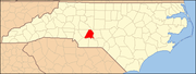
Montgomery County is a rural county located in the southern Piedmont of the U.S. state of North Carolina. As of the 2020 census, the population was 25,751. Its county seat is Troy.

<span class="mw-page-title-main">Dillon County, South Carolina</span> County in South Carolina, United States

Dillon County is a county located in the U.S. state of South Carolina. As of the 2020 census, the county's population was 28,292. The county seat is Dillon.

<span class="mw-page-title-main">Stanly County, North Carolina</span> County in North Carolina, United States

Stanly County is a county in the U.S. state of North Carolina. As of the 2020 census, the population was 62,504. Its county seat is Albemarle.

<span class="mw-page-title-main">Forsyth County, North Carolina</span> County in North Carolina, United States

Forsyth County is located in the northwest Piedmont of the U.S. state of North Carolina. As of the 2020 census, the population was 382,590, making it the fourth-most populous county in North Carolina. Its county seat is Winston-Salem. Forsyth County is part of the Winston-Salem, NC, Metropolitan Statistical Area, which is also included in the Greensboro–Winston-Salem–High Point, NC, Combined Statistical Area. Portions of Forsyth County are in the Yadkin Valley wine region.

<span class="mw-page-title-main">Cabarrus County, North Carolina</span> County in North Carolina, United States

Cabarrus County is a county located in the south-central part of the U.S. state of North Carolina. As of the 2020 census, the population was 225,804, making it the 9th-most populous county in North Carolina. The county seat is Concord, which was incorporated in 1803. Cabarrus County is included in the Charlotte-Concord-Gastonia, NC-SC Metropolitan Statistical Area.

<span class="mw-page-title-main">Star, North Carolina</span> Town in North Carolina, United States

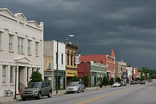
Star is a town in Montgomery County, North Carolina, United States. The population was 876 at the 2010 census.

<span class="mw-page-title-main">Albemarle, North Carolina</span> City in North Carolina, United States

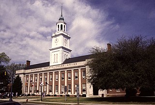
Albemarle is a city in and the county seat of Stanly County, North Carolina, United States. The population was 16,432 in the 2020 census.

<span class="mw-page-title-main">Marion, South Carolina</span> City in South Carolina, United States

Marion is a city in and the county seat of Marion County, South Carolina, United States. It is named for Francis Marion, a brigadier general from South Carolina in the American Revolutionary War. The population was 6,939 at the 2010 census.

<span class="mw-page-title-main">Bennettsville, South Carolina</span> City in South Carolina, United States

Bennettsville is a city located in the U.S. state of South Carolina on the Great Pee Dee River. As the county seat of Marlboro County, Bennettsville is noted for its historic homes and buildings from the 19th and early 20th centuries—including the Bennettsville Historic District which is listed on the National Register of Historic Places.

<span class="mw-page-title-main">Elkin, North Carolina</span> Town in North Carolina, United States

Elkin is a town in Surry and Wilkes counties in the U.S. state of North Carolina, along the Yadkin River. Elkin shares its name with the surrounding township of Elkin Township. The population was 4,122 at the time of the 2020 census.

<span class="mw-page-title-main">Yadkin River</span> River in North Carolina, United States

The Yadkin River is one of the longest rivers in the US state of North Carolina, flowing 215 miles (346 km). It rises in the northwestern portion of the state near the Blue Ridge Parkway's Thunder Hill Overlook. Several parts of the river are impounded by dams for water, power, and flood control. The river becomes the Pee Dee River at the confluence of the Uwharrie River south of the community of Badin and east of the town of Albemarle. The river then flows into South Carolina near Cheraw, which is at the Fall Line. The entirety of the Yadkin River and the Great Pee Dee River is part of the Yadkin-Pee Dee River Basin.

<span class="mw-page-title-main">Morrow Mountain State Park</span> State park in North Carolina, United States

Morrow Mountain State Park is a state park in Stanly County, North Carolina, U.S. Located near Albemarle, the park includes 5,881 acres (23.80 km2) within the Uwharrie Mountains.

<span class="mw-page-title-main">Uwharrie River</span> Stream in North Carolina, USA

The Uwharrie River () is a 61.84 mi (99.52 km) long river, in the Piedmont region of central North Carolina in the United States. It is a tributary of the Pee Dee River, which flows to the Atlantic Ocean.

<span class="mw-page-title-main">Tuckertown Reservoir</span> Reservoir in North Carolina

The Tuckertown Reservoir is the reservoir formed by the Tuckertown Dam35°29′05″N80°10′36″W at the North end of Badin Lake and the High Rock Dam 35°36′03″N80°14′06″W at the bottom of High Rock Lake in the Uwharrie Lakes Region in the U.S. state of North Carolina.

<span class="mw-page-title-main">Lake Tillery</span>

Lake Tillery is a reservoir between Falls Reservoir and Blewett Falls Lake in the Uwharrie Lakes Region of North Carolina. It is entirely within Stanly County and Montgomery County, NC. The lake was created by impounding the Pee Dee River, which is created by the confluence of the Yadkin River and the Uwharrie River several miles to the north. Norwood, NC in neighboring Stanly County uses as its town motto "Gateway to Lake Tillery".

<span class="mw-page-title-main">Badin Lake</span> Reservoir in Uwharrie Lakes Region, North Carolina

Badin Lake is one of a series of lakes created by the damming of the Yadkin-Pee Dee River in the Uwharrie Lakes Region of the United States. The Badin Lake Dam was built in 1917 to support local aluminum smelting plant, Alcoa, and the associated community of Badin was named for the founder, Adrien Badin. The power generation unit was sold to Cube Hydro Carolinas in February 2017. Badin Lake is in the Piedmont area of North Carolina. It is contained by Narrows Dam at the town of Badin, North Carolina. Sitting within a valley, the lake is very deep, with a maximum depth of 190 ft. The lake occupies 5,350 acres (22 km2) and has 115 mi (185 km) of shoreline. Its waters have an average summer temperature of 84.4 °F (29.1 °C) and an average winter temperature of 50.6 °F (10.3 °C). No ferries cross Badin Lake. The northernmost point of Morrow Mountain State Park is roughly 2 miles (3.2 km) downstream from Narrows Dam. The lake lies within Stanly, Davidson, Montgomery, and Rowan counties. Much of the lake's eastern shoreline lies within the Uwharrie National Forest.

The Battle of Colson's Mill was a battle of the American Revolutionary War that took place in North Carolina on July 21, 1780. A Patriot militia under William Lee Davidson scattered a gathering of Loyalists at Colson's Mill, near the junction of the Rocky and Pee Dee Rivers in present-day Stanly County, North Carolina.

<span class="mw-page-title-main">Yadkin–Pee Dee River Basin</span>

The Yadkin–Pee Dee River Basin is a large river basin in the eastern United States, covering around 7,221 square miles, making it the second largest in the state of North Carolina. Its headwaters rise near Blowing Rock, North Carolina, and the basin drains to the Atlantic Ocean in Winyah Bay, east of Georgetown, South Carolina.

<span class="mw-page-title-main">Eldorado Township, Montgomery County, North Carolina</span> Township in North Carolina, United States

Eldorado Township, population 1,873, is one of eleven townships in Montgomery County, North Carolina, United States. Eldorado Township is 48.97 square miles (126.8 km2) in size and is located in the northwestern corner of the county.

References

  1. "ArcGIS REST Services Directory". United States Census Bureau. Retrieved September 20, 2022.
  2. 1 2 U.S. Geological Survey Geographic Names Information System: Norwood, North Carolina
  3. 1 2 "U.S. Census website". United States Census Bureau . Retrieved January 31, 2008.
  4. "Census of Population and Housing". Census.gov. Retrieved June 4, 2015.
  5. "Explore Census Data". data.census.gov. Retrieved December 21, 2021.
  6. "National Register Information System". National Register of Historic Places . National Park Service. July 9, 2010.