Melanesia is a subregion of Oceania in the southwestern Pacific Ocean. It extends from New Guinea in the west to the Fiji Islands in the east, and includes the Arafura Sea.
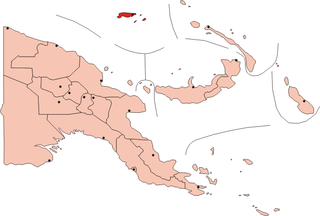
The Admiralty Islands are an archipelago group of 18 islands in the Bismarck Archipelago, to the north of New Guinea in the South Pacific Ocean. These are also sometimes called the Manus Islands, after the largest island.

Bougainville, officially the Autonomous Region of Bougainville, is an autonomous region in Papua New Guinea. The largest island is Bougainville Island, while the region also includes Buka Island and a number of outlying islands and atolls. The current capital is Buka, situated on Buka Island.

Bougainville Island is the main island of the Autonomous Region of Bougainville, which is part of Papua New Guinea. It was previously the main landmass in the German Empire-associated North Solomons. Its land area is 9,300 km2 (3,600 sq mi). The population of the whole province, including nearby islets such as the Carterets, is approximately 300,000. The highest point is Mount Balbi, on the main island, at 2,715 m (8,907 ft). The much smaller Buka Island, c. 500 km2 (190 sq mi), lies to the north, across the 400–500 m (1,300–1,600 ft) wide Buka Strait. Even though the strait is narrow, there is no bridge across it, but there is a regular ferry service between the key settlements on either side. The main airport in the north is in the town of Buka.

The Bismarck Archipelago is a group of islands off the northeastern coast of New Guinea in the western Pacific Ocean and is part of the Islands Region of Papua New Guinea. Its area is about 50,000 square km.
The Malay Archipelago or also called the Indo-Australian Archipelago is the archipelago between Mainland Southeast Asia and Australia. It has also been called the "Malay world," "Nusantara", "East Indies" and other names over time. The name was taken from the 19th-century European concept of a Malay race, later based on the distribution of Austronesian languages.
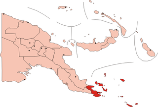
The Louisiade Archipelago is a string of ten larger volcanic islands frequently fringed by coral reefs, and 90 smaller coral islands in Papua New Guinea.

The Bismarck Sea lies in the southwestern Pacific Ocean within the nation of Papua New Guinea. It is located northeast of the island of New Guinea and south of the Bismarck Archipelago. It has coastlines in districts of the Islands Region, Momase Region, and Papua Region.
Misima is a volcanic island in the northwest of Louisiade Archipelago within Milne Bay Province of Papua New Guinea.

The Territory of Papua and New Guinea, officially the Administrative Union of the Territory of Papua and the Territory of New Guinea, was established by an administrative union between the Australian-administered territories of Papua and New Guinea in 1949. In December 1971, the name of the Territory changed to "Papua New Guinea" and in 1975 it became the Independent State of Papua New Guinea.

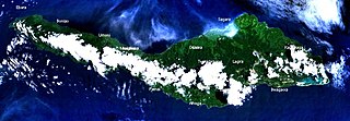
New Ireland, or Latangai, is a large island in Papua New Guinea, approximately 7,404 km2 (2,859 sq mi) in area with c. 120,000 people. It is named after the island of Ireland. It is the largest island of New Ireland Province, lying northeast of the island of New Britain. Both islands are part of the Bismarck Archipelago, named after Otto von Bismarck, and they are separated by Saint George's Channel.

Ptychosperma is a genus of flowering plant in the family Arecaceae. Most are native to Australia and/or New Guinea, with a few in the Solomon Islands and in Maluku Province of eastern Indonesia. Some have been cultivated abroad as house or garden plants, and reportedly naturalized in certain regions.

The Maggie Taylor's roundleaf bat is a species of bat in the family Hipposideridae. It is found in West Papua (Indonesia) and Papua New Guinea.

New Guinea is the world's second-largest island, with an area of 785,753 km2 (303,381 sq mi). Located in Oceania in the southwestern Pacific Ocean, the island is separated from Australia by the 150-kilometre wide Torres Strait, though both landmasses lie on the same continental shelf. Numerous smaller islands are located to the west and east.

The Solomon Islands (archipelago) is an island group in the western South Pacific Ocean, north-east of Australia. The archipelago is in the Melanesian subregion and bioregion of Oceania and forms the eastern boundary of the Solomon Sea. The many islands of the archipelago are distributed across Papua New Guinea and Solomon Islands (country). The largest island in the archipelago is Bougainville Island, which is a part of the Autonomous Region of Bougainville along with Buka Island, the Nukumanu Islands, and a number of smaller nearby islands. Much of the remainder falls within the territory of Solomon Islands and include the atolls of Ontong Java, Sikaiana, the raised coral atolls of Bellona and Rennell, and the high islands of Choiseul, Guadalcanal, Makira, Malaita, New Georgia, the Nggelas, Santa Isabel, and the Shortlands. The Santa Cruz Islands are not a part of the archipelago.

The Duchateau Islands are an island group in the Coral Sea, belonging to Papua New Guinea. They lie to the east of Panarairai Island in the Louisiade Archipelago.
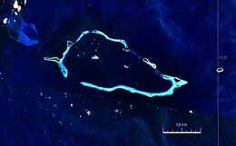
The Conflict Group is an atoll in Papua New Guinea. The group was sighted in 1879 by HMS Cormorant, by moonlight; it was named in 1880 by Bower, captain of HMS Conflict. Irai Island is the center of population of the group.
Bagaman Island is an island of Papua New Guinea, part of the Calvados Chain within the Louisiade Archipelago. Misima language is the native language on the island.
Brumer Islands are an island group of Papua New Guinea.
Utian Island, also known as Brooker Island, is an island in Papua New Guinea, part of the Calvados Chain within the Louisiade Archipelago. It is located at the western end of the Calvados Chain, in the Louisiade Archipelago, in the Milne Bay Province.