This article needs additional citations for verification .(March 2016) |
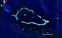
Geography | |
---|---|
Location | Oceania |
Coordinates | 10°46′48″S151°47′32″E / 10.78000°S 151.79222°E [1] |
Archipelago | Louisiade Archipelago |
Adjacent to | Solomon Sea |
Total islands | 21 |
Major islands | |
Area | 4.55 km2 (1.76 sq mi) |
Length | 21 km (13 mi) |
Width | 10 km (6 mi) |
Administration | |
Province | Milne Bay |
District | Samarai-Murua District |
LLG [2] | Bwanabwana Rural LLG |
Island Group | Calvados Chain |
Largest settlement | Irai (pop. 20) |
Demographics | |
Population | 30 (2014) |
Pop. density | 6.6/km2 (17.1/sq mi) |
Ethnic groups | Papauans, Austronesians, Melanesians. |
Additional information | |
Time zone | |
ISO code | PG-MBA |
Official website | www |
The Conflict Group is an atoll in Papua New Guinea. The group was sighted in 1879 by HMS Cormorant, by moonlight; it was named in 1880 by Bower, captain of HMS Conflict. [3] Irai Island is the center of population of the group.
The small Panasesa Island has an eco resort with a small staff.
In September 2022 the Papua New Guinea government ordered an investigation into the islands' ownership after their owner, Australian businessman Ian Gowrie Smith, attempted to sell them. [4]
The individual islands in a clockwise direction, starting in the west (Kisa and Itamarina in the lagoon):
Differing surface areas, and sometimes divergent names for individual islands can be found in Oceandots: Irai (97 ha), Panasesa (63.5 ha), Auriora (61 ha), Panarakum (38.8 ha), Panibari (24.7 ha), Tubiniguam (17.8 ha), Moniara (13 ha), Ginouri (11 ha) and Tupit (10 ha). Thereafter, the total land area of the archipelago is 3.75 km². [5]
Papua is a province of Indonesia, comprising the northern coast of Western New Guinea together with island groups in Cenderawasih Bay to the west. It roughly follows the borders of Papuan customary region of Tabi Saireri. It is bordered by the sovereign state of Papua New Guinea to the east, the Pacific Ocean to the north, Cenderawasih Bay to the west, and the provinces of Central Papua and Highland Papua to the south. The province also shares maritime boundaries with Palau in the Pacific. Following the splitting off of twenty regencies to create the three new provinces of Central Papua, Highland Papua, and South Papua on 30 June 2022, the residual province is divided into eight regencies (kabupaten) and one city (kota), the latter being the provincial capital of Jayapura. The province has a large potential in natural resources, such as gold, nickel, petroleum, etc. Papua, along with five other Papuan provinces, has a higher degree of autonomy level compared to other Indonesian provinces.
Papua New Guinea, officially the Independent State of Papua New Guinea, is a country in Oceania that comprises the eastern half of the island of New Guinea and its offshore islands in Melanesia. It shares its only land border with Indonesia to the west and it is directly adjacent to Australia to the south and the Solomon Islands to the east. Its capital, located along its southeastern coast, is Port Moresby. The country is the world's third largest island country, with an area of 462,840 km2 (178,700 sq mi).
Bougainville, officially the Autonomous Region of Bougainville, is an autonomous region in Papua New Guinea. The largest island is Bougainville Island, while the region also includes Buka Island and a number of outlying islands and atolls. The current capital is Buka, situated on Buka Island.
Solomon Islands is a country consisting of six major islands and over 900 smaller islands in Melanesia, part of Oceania, to the northeast of Australia. It is directly adjacent to Papua New Guinea to the northwest, Australia to the southwest, New Caledonia and Vanuatu to the southeast, Fiji, Wallis and Futuna and Tuvalu to the east, Nauru and the Federated States of Micronesia to the north. It has a total area of 29,000 square kilometres, and a population of approximately 700,000. Its capital, Honiara, is located on the largest island, Guadalcanal. The country takes its name from the wider area of the Solomon Islands (archipelago), which is a collection of Melanesian islands that also includes the Autonomous Region of Bougainville, but excludes the Santa Cruz Islands.
Bougainville, an autonomous region of Papua New Guinea (PNG), has been inhabited by humans for at least 29,000 years, according to artefacts found in Kilu Cave on Buka Island. The region is named after Bougainville Island, the largest island of the Solomon Islands archipelago, but also contains a number of smaller islands.
Western New Guinea, also known as Papua, Indonesian New Guinea, Indonesian Papua, is the western, Indonesian half of the island of New Guinea. Since the island is alternatively named Papua, the region is also called West Papua.
D'Entrecasteaux Islands are situated near the eastern tip of New Guinea in the Solomon Sea in Milne Bay Province of Papua New Guinea. The group spans a distance of 160 km (99 mi), has a total land area of approximately 3,100 km2 (1,197 sq mi) and is separated from the Papua New Guinea mainland by the 30 km (19 mi) wide Ward Hunt Strait in the north and the 18 km (11 mi) wide Goschen Strait in the south. D'Entrecasteaux Islands show signs of volcanism.
Normanby Island is a volcanic 1,000-square-kilometre (390 sq mi), L-shaped and mountainous island, the southernmost island in the D'Entrecasteaux Islands group. It is part of Milne Bay Province, Papua New Guinea. The island has an irregular and elongated shape measuring 73km in length (northwest-southeast).
The Carteret Islands are Papua New Guinea islands located 86 km (53 mi) north-east of Bougainville in the South Pacific. The atoll has a scattering of low-lying islands called Han, Jangain, Yesila, Yolasa and Piul, in a horseshoe shape stretching 30 km (19 mi) in north-south direction, with a total land area of 0.6 square kilometres (0.2 sq mi) and a maximum elevation of 1.5 metres above sea level.
Metis Shoal, also known as Lateiki Island, is a volcanic island at the top of a submarine volcano in Tonga, located between the islands of Kao and Late. The current island formed in October 2019, when a smaller island disappeared after 24 years.
The Tabar Group is an island group in Papua New Guinea, located 40 km (25 mi) north of New Ireland. It is a part of the Bismarck Archipelago. The Tabar group consists of a short chain of three main islands - Tabar Island in the south, Tatau Island in the center, and Simberi Island in the north - as well as a number of smaller offshore islets. The highest peak is Mount Beirari at 622 m (2,041 ft).
The continent of Australia, sometimes known in technical contexts by the names Sahul, Australia-New Guinea, Australinea, or Meganesia to distinguish it from the country of Australia, is located within the Southern and Eastern hemispheres. The name "Sahul" takes its name from the Sahul Shelf, which is a part of the continental shelf of the Australian continent. The continent includes mainland Australia, Tasmania, the island of New Guinea, the Aru Islands, the Ashmore and Cartier Islands, most of the Coral Sea Islands, and some other nearby islands. Situated in the geographical region of Oceania, Australia is the smallest of the seven traditional continents.
New Guinea is the world's second-largest island, with an area of 785,753 km2 (303,381 sq mi). Located in Melanesia in the southwestern Pacific Ocean, the island is separated from Australia by the 150-kilometre wide Torres Strait, though both landmasses lie on the same continental shelf. Numerous smaller islands are located to the west and east. The name "New Guinea" was given by Spanish explorer Yñigo Ortiz de Retez during his maritime expedition of 1545 due to the resemblance of the indigenous peoples of the island to those in the African region of Guinea.
The Papua conflict is an ongoing conflict in Western New Guinea (Papua) between Indonesia and the Free Papua Movement. Subsequent to the withdrawal of the Dutch administration from the Netherlands New Guinea in 1962 and implementation of Indonesian administration in 1963, the Free Papua Movement has conducted a low-intensity guerrilla war against Indonesia through the targeting of its military, police, and civilian populations.
The Bougainville conflict, also known as the Bougainville Civil War, was a multi-layered armed conflict fought from 1988 to 1998 in the North Solomons Province of Papua New Guinea (PNG) between PNG and the secessionist forces of the Bougainville Revolutionary Army (BRA), and between the BRA and other armed groups on Bougainville. The conflict was described by Bougainvillean President John Momis as the largest conflict in Oceania since the end of World War II in 1945, with an estimated 15,000–20,000 Bougainvilleans dead, although lower estimates place the toll at around 1,000–2,000.
The Calvados Chain are a group of islands in the Solomon Sea, belonging to Papua New Guinea within the Louisiade Archipelago.
Bramble Haven is an atoll in the Louisiade Archipelago. Its islands on the northern section are grouped as the Duperre Islands.
Irai Island is the main island of the Conflict Islands, which were sighted in 1879 by HMS Cormorant and named in 1880 by Bower, captain of HMS Conflict.
Panasesa Island is located in Milne Bay Province, Papua New Guinea, 500 km to the east of Port Moresby, the nation's capital. Panasesa Island has an eco resort with small staff.
Papua New Guinea (PNG) is officially known as the Independent State of Papua New Guinea after gaining absolute independence from Australia on September 16, 1975. PNG is the largest country in the South Pacific region and comprises the eastern side of New Guinea including its islands. Crime in Papua New Guinea, both violent and non-violent, have contributed to the developing country's crime rate being one of the highest in the world.