Baluan Island

Last updated
Baluan Island
Baluan Island.jpg
Balaun Island from the air
Admiralty Islands Topography with labels.png
Map of the Admiralty Islands
Geography
Coordinates 2°33′30″S147°17′02″E / 2.558265°S 147.283895°E / -2.558265; 147.283895
Archipelago Admiralty Islands, Bismarck Archipelago
Area14 km2 (5.4 sq mi)
Width5 km (3.1 mi)
Coastline16 km (9.9 mi)
Highest pointSaboma Crater
Administration
Province Manus Province
District Manus District
Local-Level Government Balopa Rural
Demographics
Population1,910 (2011 Census)
Additional information
Time zone

Baluan Island (formerly known as Saint Patrick Island) is the southernmost island of the Admiralty Islands group which makes up the majority of Manus Province in Papua New Guinea. It belongs to the Pam Islands, an island subgroup to the south of Lou Island. It is formed from an extinct volcano, also named Baluan.

Contents

Geography

Looking towards the coast of Baluan Sailing outrigger canoe.JPG
Looking towards the coast of Baluan

Baluan is formed by a Pleistocene stratovolcano with a large summit crater and several flank vents, some of which might be from the Holocene age. Baluan has erupted basaltic rock rather than rhyolitic rocks like its neighbours. Several small islands consisting of cone remnants are located within 1 kilometre (0.62 mi) of the north coast. Geothermal activity is observed in coastal areas. [1] Volcanic activity is evident from the hot water springs which emerge close to the shore which are mostly covered by the tide. There is a reef which surrounds the island and prevents the sea from damaging the coast. [2]

The Saboma Crater is the highest point on the island, at 254 metres (833 ft) above sea level. It forms the crater rim of the inactive volcano in the middle of the island. It has a maximum width of about 2 kilometres (1.2 mi). The sides of the crater are densely forested. On the east and south sides of the island there are a number of beaches. [3]

Batapona Mountain, which has an elevation of 150 metres (490 ft), is located at the north edge of the island, and is formed of an arcuate rim and pyroclastic cone.

There is an unconfirmed report of an eruption near the island in 1931 from a submarine vent. [1] Contrastingly, the nearby St. Andrew Strait volcano, off the shore of neighbouring Lou Island, is confirmed to have erupted from 1953 to 1957, which created nearby Tuluman Island. [4]

Lifestyle

Demographics

There are several settlements on Baluan, including Mouk, Lipan, Sone, and Parioi, which according to the 2011 National Census have a combined population of 1,910. [5] The island is situated within the Local-Level Government region of Balopa (Baluan, Lou, Pam Islands). A significant portion of Baluan's population live away from the island to work in urban areas. [6]

The languages of Titan and Baluan-Pam, known as locally as Paluai, are spoken on the island, in addition to Tok Pisin.

Festival de Confolens Performers from Baluan participating in the French Confolens Festival in 2004 2004-Folk-Confolens 05.JPG
Festival de Confolens Performers from Baluan participating in the French Confolens Festival in 2004

Culture

In the early 20th century, the entire population was converted to Christianity, the two main denominations being Catholicism and the Seventh-day Adventists. Tok Pisin is normally used for Church services. Christianity does however operate parallel to other traditional belief systems, which mainly relate to illness and cure. [3] Many Balauan people are members of the Baluan Native Christian United Church, founded in 1946 by Paliau Maloat. The creation of this denomination was in response to oppression under colonial administration from Australia. [7] [8]

The Balopa Cultural Festival takes place on Baluan, which is the largest cultural event on the island and involves the neighbouring islands Lou and the Pam Islands as well. [9]

On New Year's Day every year, a set of bright lights appear in the night sky. The colours of these lights are said to be indicative of how good the following year will be. In a bad year, where the lights are red and white for example, there may be more sickness and more of the elderly may pass away. This phenomenon has occurred since at least the mid 20th century, and does not currently have a scientific explanation. [10]

A bush house on Baluan Baluan bush house.JPG
A bush house on Baluan

Settlements

One of the main settlements on the island is Mouk, situated on the northern end of the island, which had a population of 341 in the 2011 National Census. [5] The people of Mouk are fishers and seafarers traditionally who speak Titan, and were invited to the island in the late 1940s, moving from the small nearby island of the same name. [6] Prior to that, they had originated from Pere on the southern coast of Manus Island. [11] It is speculated that they were invited to the island in order to protect against other groups which speak Titan, located on the southern coast of Manus Island and in the M'Buke Islands, as they were known for their raids on distant islands. [2]

In pre-colonial times, villages acted as political units, consisting of multiple groups with common ancestors. Houses of high status and their leader, were called lapan. Disputes between groups could either be resolved through warfare, or through the preparation of a large feast, which would take several years to prepare. [3]

Most settlements are on the coast. Houses are built elevated from the ground, sometimes with a veranda. A separate building is generally used for cooking. Garden plots are generally not placed next to houses. Family lineages each possess their own land for creating gardens, however this information can be difficult to find. [3]

Black basalt rocks found in the island's soil have been used to build stone walls throughout the island, which surround gardens and former house sites. [2]

Economy

As a third of Baluan's population does not live on the island, remittances are an important source of income for those living on the island. This practice has raised the living standards in Baluan significantly over time. [2] Most people on the island live a subsistence-based lifestyle, however there are markets on the island for purchasing store goods. A wider selection of store goods can be found at stores in Lorengau. While there are cocoa and coconut plantations on the island, they do not always export, as the cost of petrol to transport produce to the mainland creates additional expense. [3]

Education

Primary education was established on the island in 1951. [12] There are three elementary schools and one primary school located in Lipan. From grade three onwards, all teaching takes place in English. For continuing to secondary school, students have to leave Baluan for Lorengau or go elsewhere. Education is highly valued in Baluan society, because of the Western knowledge it provides, and the employment opportunities outside of Baluan which come with it. [3]

1957 topographical map of Baluan 1957 Map of Baluan Island.png
1957 topographical map of Baluan

Agriculture

The main foods on the island are fish and vegetables grown on the volcanic soil. Strewn with black basalt rocks, the soil is more fertile than what is found on most of the islands in the archipelago. [2] Baluan is surrounded by coral reefs, which provides fish, crustaceans, and sea turtles which can be hunted for their meat. The environmental conditions on Baluan in pre-colonial times did and continue to allow for a subsistence-based lifestyle. In large gardens, people grow taro, yams, pawpaw, banana, sweet potato, pineapple, sugarcane, and corn. Breadfruit, mango and coconuts can be obtained from trees which grow throughout island. The eggs of a bird known as the white fowl are also dug out for consumption. [3] The island has no fresh water, therefore drinking water must be obtained by catching rain water.

Notable residents

A prominent figure from Baluan was Sir Paliau Maloat OBE (1907 – 1991), who was elected as the First National Member of Assembly for Manus Province in 1964. He is known for creating the Paliau Movement, which advocated for the people of the Admiralty Islands to adopt Western and Christian values, expand economic development, and ensure the emancipation of women in the society, in order to modernise Manusian society. [13] He died in 1991 and is buried on Baluan.

Winnie Kiap CBE was born on Baluan and is the High Commissioner of Papua New Guinea to the United Kingdom, and previously served as Secretary to the National Executive Council of Papua New Guinea.

See also

Related Research Articles

<span class="mw-page-title-main">Admiralty Islands</span> Archipelago in the South Pacific Ocean

The Admiralty Islands are an archipelago group of 18 islands in the Bismarck Archipelago, to the north of New Guinea in the South Pacific Ocean. These are also sometimes called the Manus Islands, after the largest island.

<span class="mw-page-title-main">Bismarck Archipelago</span> Archipelago in northeast Papua New Guinea

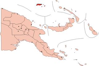
The Bismarck Archipelago is a group of islands off the northeastern coast of New Guinea in the western Pacific Ocean and is part of the Islands Region of Papua New Guinea. Its area is about 50,000 square km.

<span class="mw-page-title-main">Manus Island</span> Island within Manus Province, Papua New Guinea

Manus Island is part of Manus Province in northern Papua New Guinea and is the largest of the Admiralty Islands. It is the fifth-largest island in Papua New Guinea, with an area of 2,100 km2 (810 sq mi), measuring around 100 km × 30 km. Manus Island is covered in rugged jungles which can be broadly described as lowland tropical rain forest. The highest point on Manus Island is Mt. Dremsel, 718 metres (2,356 ft) above sea level at the centre of the south coast. Manus Island is volcanic in origin and probably broke through the ocean's surface in the late Miocene, 8 to 10 million years ago. The substrate of the island is either directly volcanic or from uplifted coral limestone.

<span class="mw-page-title-main">Ambrym</span> Volcanic island in Vanuatu

Ambrym is a volcanic island in Malampa Province in the archipelago of Vanuatu. Volcanic activity on the island includes lava lakes in two craters near the summit.

<span class="mw-page-title-main">Admiralty Islands languages</span> Oceanic language group

The Admiralty Islands languages are a group of some thirty Oceanic languages spoken on the Admiralty Islands. They may include Yapese, which has proven difficult to classify.

<span class="mw-page-title-main">Karkar Island</span> Volcanic island in New Guinea

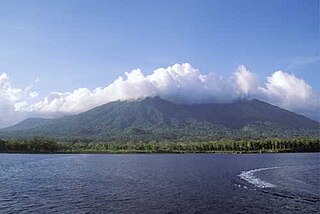
Karkar Island is an oval-shaped volcanic island located in the Bismarck Sea, about 30 kilometres off the north coast of mainland Papua New Guinea in Madang Province, from which it is separated by the Isumrud Strait. The island is about 25 km in length and 19 km in width. In the centre is an active volcano with two nested calderas.

<span class="mw-page-title-main">Rambutyo Island</span> Island in Papua New Guinea

Rambutyo Island is one of the Admiralty Islands in the Bismarck Archipelago. Politically, Rambutyo Island is part of Manus Province, Papua New Guinea. The population (unknown) is concentrated on the west coast. Villages include Mouklen and Lengkau.

<span class="mw-page-title-main">Ritter Island</span> Small volcanic island in Papua New Guinea

Ritter Island is a small crescent-shaped volcanic island 100 kilometres (62 mi) north-east of New Guinea, situated between Umboi Island and Sakar Island.

<span class="mw-page-title-main">Long Island (Papua New Guinea)</span> Volcanic island north of New Guinea

Long Island is a populated volcanic island in Madang Province, Papua New Guinea. It is located north of the island of New Guinea, separated from it by the Vitiaz Strait. The island's interior contains a 360m deep freshwater volcanic crater lake and within that lake exists an even smaller island known as Motmot island. During the late 17th or early 18th century virtually all of the biota on the island was destroyed and has subsequently provided scientists a unique opportunity to study recolonization efforts by plants, animals, and humans. The vast majority of the buildings on the island are constructed using vernacular architecture.

<span class="mw-page-title-main">Lihir Island</span> Island in Papua New Guinea

Lihir Island is the largest island in the Lihir group of islands, 22 km long and 14.5 km wide, in Papua New Guinea's New Ireland Province. It consists of a complex of several overlapping basaltic stratovolcanoes rising 700 m above sea level. While the volcanoes are not currently active, geothermal activity is still present. The island is in what was the forearc basin associated with the subduction of the Pacific Plate beneath the North Bismarck Plate. Subduction stopped about 10 million years ago with the collision of the Ontong Java plateau with the subduction zone.

<span class="mw-page-title-main">Mount Balbi</span>

Mount Balbi is a Holocene stratovolcano located in the northern portion of the island of Bougainville, Papua New Guinea. A gentle prominence at 05°54′09″S154°59′28″E is the highest point of the island. There are five volcanic craters east of the summit, one of which contains a crater lake. The summit is composed of coalesced cones and lava domes which host a large solfatera field. There are numerous fumaroles near the craters, though Balbi has not erupted in historic time.

<span class="mw-page-title-main">Billy Mitchell (volcano)</span> Crater lake in Bougainville Island

Billy Mitchell is a pyroclastic shield in the central part of the island of Bougainville, just north-east of the Bagana Volcano in Papua New Guinea. It is a small pyroclastic shield truncated by a 2 km wide caldera filled by a crater lake. It is named after Billy Mitchell, a 20th-century United States Army general who is regarded as the father of the United States Air Force.

<span class="mw-page-title-main">Cameroon line</span> Chain of volcanoes in the Gulf of Guinea

The Cameroon line is a 1,600 km (1,000 mi) long chain of volcanoes that includes islands in the Gulf of Guinea and mountains on the African mainland, from Mount Cameroon on the coast towards Lake Chad on the northeast. They form a natural border between eastern Nigeria and the West Region of Cameroon. The islands, which span the equator, have tropical climates and are home to many unique plant and bird species. The mainland mountain regions are much cooler than the surrounding lowlands, and also contain unique and ecologically important environments.

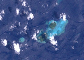
St. Andrew Strait is a volcano in Papua New Guinea that has had eruptions in historical times. The volcano is not linked to any tectonic plates, the volcano is also in an area of very few earthquakes, suggesting that St. Andrew Strait is an Intraplate volcano. It consists of a group of Quaternary volcanic cones that are mainly rhyolitic in composition. The volcanism is curved, suggesting that the volcano has an ancient caldera. The centre of the volcano is Lou Island. Lou island last erupted in 240 BC and 340 AD, both eruptions came from the Bendal volcano. Lou island is the largest eruptive centre of the volcano, with 6 volcanic vents. Also the Pam islands also contain fresh deposits. Historic eruptions have come from the Tuluman Islands.

Victory is a volcano on New Guinea island, Papua New Guinea. It is situated on Cape Nelson, 30 km from Tufi in an area with no Wadati-Benioff zone. It is one of four large stratovolcanos in Northern New Guinea island, the others being Hydrographers Range, Trafalgar and Lamington.

<span class="mw-page-title-main">Baluan-Pam language</span> Oceanic language of Manus Province, Papua New Guinea

Baluan-Pam is an Oceanic language of Manus Province, Papua New Guinea. It is spoken on Baluan Island and on nearby Pam Island. The number of speakers, according to the latest estimate based on the 2000 Census, is 2,000. Speakers on Baluan Island prefer to refer to their language with its native name Paluai.

<span class="mw-page-title-main">Pam Islands</span>

The Pam Islands are an island group of the Admiralty Islands archipelago in the Bismarck Sea, within Papua New Guinea.

The Hydrographers Range is a forested mountain range in the Oro Province of southeastern Papua New Guinea. It extends from the eastern margin of Mount Lamington in the west to the Pacific Ocean coast in the east.

Balopa Rural LLG is a local-level government (LLG) of Manus Province, Papua New Guinea.

<span class="mw-page-title-main">Bam Island (Papua New Guinea)</span> Volcanic island in Papua New Guinea

Bam, also known as Biem, is a small volcanic island off the coast of Papua New Guinea, 40 km north northeast of the Sepik river mouth. It represents the southernmost island of the Schouten Islands. The northern coast of the island is inhabited by a village and coconut groves. Much of the island is forested, except along its south flank. As of 2018, the island has a population of approximately 3,000 people.

References

  1. 1 2 "Baluan". Global Volcanism Program . Smithsonian Institution . Retrieved 2021-06-25.
  2. 1 2 3 4 5 Otto, Ton (1991). The Politics of Tradition in Baluan Social Change and the Construction of the Past in a Manus Society.
  3. 1 2 3 4 5 6 7 Schokkin, Gerda Hendrike (2010). The Paluai language of Baluan Island – A brief preliminary overview. The Cairns Institute. p. 4.
  4. "St. Andrew Strait". Global Volcanism Program . Smithsonian Institution . Retrieved 2021-06-25.
  5. 1 2 "Ward Population Profile Islands Region". National Statistical Office. Archived from the original on 2020-08-08. Retrieved 2019-06-02.
  6. 1 2 Otto, Ton (Jun 1992). "The Ways of Kastam: Tradition as Category and Practice in a Manus Village". Oceania. 62 (4): 264–283. doi:10.1002/j.1834-4461.1992.tb00357.x. JSTOR   40332505.
  7. "Paliau movement - Manus province, Papua New Guinea". pngbuai.com. Retrieved 2019-06-02.
  8. "Baluan Native Christian United Church". Overview Of World Religions. 6 Oct 2006. Archived from the original on 6 October 2006.
  9. Dalsgaard, Steffen; Nielsen, Morten (2015-11-01). Time and the Field. Berghahn Books. ISBN   9781785330889.
  10. Brooksbank, John (January 2001). "Mysteries of Manus". Paradise Magazine.
  11. Crocombe, R.G. (1965). The M'Buke Co-operative Plantation. Canberra: New Guinea Research Unit, Australian National University. p. 48.
  12. Ulijaszek, Stanley J. (2006). Population, Reproduction, and Fertility in Melanesia. Berghahn Books. ISBN   9781571816443.
  13. "Paliau Maloat - how one man changed Manus forever". Keith Jackson & Friends: PNG ATTITUDE. Retrieved 2019-06-02.