Autumn 2000 Western Europe floods

Last updated

Autumn 2000 Western Europe floods
Shrewsbury Abbey from the west - geograph.org.uk - 56158.jpg
Shrewsbury Abbey on 1 November
Datemid-September 2000 – mid-December 2000 [1]
LocationUnited Kingdom, Italy, France, Switzerland, Spain, Netherlands, Ireland, Denmark, Norway, Slovenia
Deaths20
Property damageEstimated to exceed $2 billion [2]

The Autumn of 2000 was the wettest recorded in the United Kingdom since records began in 1766. [3] [4] [5] Several regions of Atlantic Europe from France to Norway received double their average rainfall and there were severe floods and landslides in the southern Alps. [6] In October and November 2000 a successive series of extratropical cyclones caused severe flooding across the UK. [7] [8]

Contents

The United Kingdom saw the most extensive nationwide [9] flooding event since the snow-melt of 1947. [4] Prior to 1947, three similar events occurred in the second half of the 19th century where prolonged rainfall led to widespread flooding throughout England in the month of November, namely 1894, 1875, and 1852. [3]

The combined effect of the storms across Western Europe caused flooding throughout the United Kingdom. Two storm events (Nicole and Oratia) 28 October to 3 November, and the storm Rebekka from 4 November, resulted in continuous flooding. [10] [11] 10,000 homes were flooded in 700 locations. [4] Peak flows on the Rivers Thames, Trent, Severn, Wharfe and Dee were the highest for 60 years. The River Ouse in Yorkshire reached the highest level since the 17th century. [4]

In the United Kingdom a series of severe floods affected large parts of the country in the Autumn of 2000. The worst affected areas were Kent and Sussex during October and Shropshire, Worcestershire and Yorkshire in November. The Autumn of 2000 was the wettest on record in the England and Wales precipitation record with several major rainfall events causing flooding in different parts of the country during October and November. England and Wales had an average of 503 mm of rain from September–November exceeding the previous record by nearly 50 mm. [12]

Meteorological background

A succession of slow-moving low pressure systems crossed the UK during Autumn 2000 associated with the jet stream being in a more southerly position than average. [13] The flooding in Kent and Sussex resulted from a succession of thunderstorms passing along a near-stationary front. [14] Much of the rock in this area is impermeable and there had already been significant rainfall in the south-east allowing for increased surface flow and river levels. Several fronts passed over central and northern England in the following weeks causing flooding in Shropshire, Worcestershire and Yorkshire.

Prelude

The rainfall for this period in the three preceding years had been above the 1961-1990 average. [14] The previous spring was unsettled, with April and May particularly wet, [8] which increased the aquifer recharge season. [14] Heavy rain was also seen in June, leading to high river levels and some flooding in Yorkshire. [8]

September 2000 was generally unsettled, with wet periods between 14 and 19. This resulted in some flooding on 15 September around Portsmouth and Southsea as a pumping station at Eastney failed after 58 mm (2.3 in) of rain fell in 4.5 hours, being the heaviest rain since 1986 in the area. Total rainfall was also measured at 65mm in Havant making this a 1 in 108 year storm event. [15] Storms affected Flanders in Belgium 15 September, with tornados reported in the municipalities of Zwalm, Antwerp and Erpe-Mere. Flooding affected the regions of Ghent and Kortrijk. [16] 24 out of 27 UK Met Office regions except northern Scotland received higher than normal rainfall during the month, making this the wettest September since 1981. [5]

Ex-Hurricane Isaac, 2–4 October

Ex-Hurricane Isaac crossed the Atlantic with eye still visible on 2 October [17] and lashed the west of the British isles with near gale-force winds on 3 October, before merging with another extra-tropical low on 4 October towards the north of Scotland. [18] Early October 2000 brought more than the monthly average rainfall in the first 10 days to the southeast of England. [19]

Ex-Tropical Storm Leslie, 9–14 October

Ex-TS Leslie (Imke/Heidrun [20] )
Type European windstorm
Extratropical cyclone
Formed7 October 2000
Dissipated14 October 2000
Highest gust0 km/h (0 mph) in
Lowest pressure963 mb (28.4 inHg) [21]
Areas affectedWestern Europe

A complex of low pressures, named Heidrun & Imke [22] by FU Berlin formed from the remnants of Tropical Storm Leslie. This formed at 30˚N 76˚W on 5 October, swept westwards and merged with a front on 7 October, and then reintensified to become a storm south of Great Britain with winds of 40-50 knots reported in the Bay of Biscay. [23] An area of convective storms stalled over Sussex and Kent.

Affected areas

Kent

Homes in Yalding and Maidstone were flooded, however there had been fears that a high tide might lead to the River Medway bursting its banks. This threat passed preventing much more widespread damage. [25] Evacuations took place in some villages in the county.

Sussex

On 12 October many roads were flooded across both West and East Sussex including the A21 and A22. A lifeboat crew rescued 20 people trapped in a supermarket in Uckfield and others were rescued by helicopter. [26]

Shropshire

Shrewsbury, Ironbridge and Bridgnorth flooded as the Severn breached its banks and reached its highest levels in 53 years. [27]

Worcestershire

The Severn breached its banks in many parts of the county, including at Bewdley, Worcester and Upton-upon-Severn. In Worcester, the Severn peaked on 3 November at its highest level in 53 years. The river remained in flood for several days however and the main road bridge in the city was closed. Homes were flooded in Diglis as well as many businesses on the city's waterfront and the cricket ground. In Bewdley, the floods led to renewed calls for flood defences in the town. [28] These were completed in 2006 and have since reduced the impact of flooding on the town.

Yorkshire

The Ouse in flood, York The Ouse in flood. York - geograph.org.uk - 126451.jpg
The Ouse in flood, York

Flooding affected York during the summer and autumn of 2000 as the River Ouse reached its highest levels since records began. The floods cost the city council in excess of £1 million and 40 people had to be moved from their homes. [29] The floods were the worst in 375 years; more than 300 homes were flooded and the army were called in to help with flood relief efforts. [30]

Aftermath

Warm sea surface temperatures in the English Channel and Norway, [31] along with an abnormally warm North Atlantic, added moisture and energy to weather systems as they crossed the UK. [8] September was the wettest since 1981, October the wettest since 1903 and November the wettest since 1970. Overall the autumn of 2000 was the wettest since 1872, and more rain fell in September, October and November than in any other 3-month period since rainfall records began in 1727. [8]

Government report

Defra commissioned an independent review by the Institution of Civil Engineers under George Fleming. [32] The review was to consider methods of estimating and reducing flood risk and look at whether flood risk management could make more use of natural processes. The resulting report entitled Learning to Live with Rivers specifically criticised a reluctance to use computer models and inadequate representation of the dynamic effects of land use, catchment processes and climatic variability. More broadly, the report noted that sustainable flood risk management could only be achieved by working with the natural response of the river basin and by providing the necessary storage, flow reduction and discharge capacity. It concluded that floods can only be managed, not prevented, and the community must learn to live with rivers.

The report found that damage was reduced by flood defences and by timely warnings and evacuations where the defences could not hold back the water. As a result, 280,000 properties were protected from the floods, but over 10,000 properties were still flooded at an estimated cost of £1 billion.

Related Research Articles

<span class="mw-page-title-main">Climate of the United Kingdom</span> Climate of the country

The United Kingdom straddles the higher mid-latitudes between 49° and 61°N on the western seaboard of Europe. Since the UK is always in or close to the path of the polar front jet stream, frequent changes in pressure and unsettled weather are typical. Many types of weather can be experienced in a single day.

The climate of Houston is classified as a humid subtropical climate, with tropical influences. August normally ranks as the warmest month at 84.6 °F (29.2 °C) and January the coldest month at 53.1 °F (11.7 °C).

<span class="mw-page-title-main">Floods in the United States (2000–present)</span>

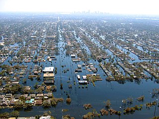
Floods in the United States (2000–present) is a list of flood events which were of significant impact to the country during the 21st century, since 2000. Floods are generally caused by excessive rainfall, excessive snowmelt, storm surge from hurricanes, and dam failure.

<span class="mw-page-title-main">2007 United Kingdom floods</span> Fatal series of natural disasters

A series of large floods occurred in parts of the United Kingdom during the summer of 2007. The worst of the flooding occurred across Scotland on 14 June; East Yorkshire and the Midlands on 15 June; Yorkshire, the Midlands, Gloucestershire, Herefordshire and Worcestershire on 25 June; and Gloucestershire, Herefordshire, Worcestershire, Oxfordshire, Berkshire and South Wales on 28 July 2007.

<span class="mw-page-title-main">Climate of the British Isles</span>

The British Isles are an archipelago off the northwest coast of Europe, consisting of the islands of Great Britain and Ireland along with smaller surrounding ones. Its position allows dry continental air from Eurasia to meet wetter air from the Atlantic Ocean, which causes the weather to be highly variable, often changing many times during the day. It is defined as a temperate oceanic climate, or Cfb on the Köppen climate classification system. It is significantly warmer than other regions on the same latitude, previously thought to be due to the warmth provided by the Gulf Stream; however, this has been disproven, and most of the mild temperatures have been linked to the Rocky Mountains and the heat storing capabilities of the North Atlantic Ocean. Temperatures do not often switch between great extremes, with warm summers and mild winters.

In Australia, the Federation Drought is the name given to a prolonged period of drought that occurred around the time of Federation in 1901.

The 1950 rainfall records for the Australian states of New South Wales and Queensland reported probably the most remarkable record high rainfall totals ever recorded anywhere in the continent. Averaged over both of these states, 1950 is clearly the wettest year since adequate records became available circa 1885. Queensland recorded a statewide average rainfall of around 1,125 millimetres (44.3 in) as against a mean since 1885 of around 640 millimetres (25.2 in), whilst New South Wales recorded around 930 millimetres (36.6 in) as against an instrumental mean around 520 millimetres (20.5 in). Australia's wettest town, Tully also recorded its highest annual rainfall total in 1950 with 7,925 millimetres (312.0 in).

Between 1979 and 1983 almost all of eastern Australia was affected by a major drought.

<span class="mw-page-title-main">Climate of south-west England</span> Typical climate of South-West England

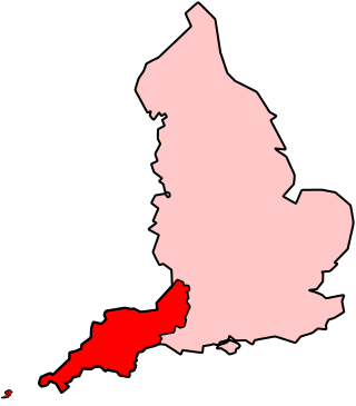
The climate of south-west England is classed as oceanic (Cfb) according to the Köppen climate classification. The oceanic climate is typified by frequent cloudy skies, cool winters with cool summers and precipitation all year round, with more experienced in winter. Annual rainfall is about 1,000 millimetres (39 in) and up to 2,000 millimetres (79 in) on higher ground. Exceptions include areas to the east of high ground ( e.g. Exeter / parts of West Somerset that are subject to a rain shadow effect and annual rainfall is closer to 30 inches.

<span class="mw-page-title-main">2000s Australian drought</span> Period of low rainfall on the continent

The 2000s drought in Australia, also known as the millennium drought is said by some to be the worst drought recorded since European settlement.

<span class="mw-page-title-main">Cyclone Carmen</span> November 2010 windstorm

Cyclone Carmen was an extratropical cyclone and European windstorm which crossed the Atlantic Ocean and affected the United Kingdom, Ireland, France, Belgium, and the Netherlands in November 2010.

<span class="mw-page-title-main">2012 Great Britain and Ireland floods</span>

The 2012 Great Britain and Ireland floods were a series of weather events that affected parts of Great Britain and Ireland periodically during the course of 2012 and on through the winter into 2013. The beginning of 2012 saw much of the United Kingdom experiencing droughts and a heat wave in March. A series of low pressure systems steered by the jet stream brought the wettest April in 100 years, and flooding across Britain and Ireland. Continuing through May and leading to the wettest beginning to June in 150 years, with flooding and extreme events occurring periodically throughout Britain and parts of Atlantic Europe.

<span class="mw-page-title-main">2013–14 United Kingdom winter floods</span> Series of 2013–2014 winter storms in the UK

The 2013–2014 United Kingdom winter floods saw areas of Ireland and the United Kingdom inundated following severe storms. The south of England saw heavy rainfalls associated with these storms which caused widespread flooding, power cuts and major disruptions to transport. Economically, the worst affected areas were Somerset, Devon, Dorset and Cornwall in the south west and the Thames Valley in the south east.

The 2015–16 UK and Ireland windstorm season was the first instance of the United Kingdom's Met Office and Ireland's Met Éireann naming extratropical cyclones. The season started on 10 November with the naming of Storm Abigail and ended on 28 March with the dissipation of Storm Katie. With a total of eleven named storms, the 2015–16 season is the most active to date.

<span class="mw-page-title-main">2015–16 Great Britain and Ireland floods</span> Flooding in Great Britain and Ireland during the winter of late 2015 and early 2016

The 2015–2016 Great Britain and Ireland floods were a series of heavy rainfall events which led to flooding during the winter of late 2015 and early 2016. 11 named storms produced record level rainfall from November 2015 - March 2016 in both monthly and seasonal accumulation records.

<span class="mw-page-title-main">2019–20 United Kingdom floods</span> Severe flooding events in the United Kingdom over the winter of 2019–2020

Between November 2019 and February 2020, severe winter flooding occurred across the United Kingdom. The first wave of flooding occurred in November 2019, mainly affecting Yorkshire and the Humber, the East Midlands and the West Midlands. Further isolated flooding incidents were reported in December and January, before the second main wave of flooding, caused by Storms Ciara and Dennis, occurred in February 2020. The excessive rainfall resulted in the wettest February since records began, in 1766, in England and Wales with an average of 169.6 millimetres (6.68 in) falling across the regions, beating the record from 1833.

<span class="mw-page-title-main">2019 Yorkshire Dales floods</span> July 2019 floods in the Yorkshire Dales, England

In July 2019, parts of the Yorkshire Dales, in North Yorkshire, England, were subjected to above average rainfall for the time of year. The flash-flooding that followed affected many communities destroying bridges, sweeping roads away, causing landslips on railway lines and resulting in at least one public event being cancelled. The flooding even inundated the fire station in the town of Leyburn, in Wensleydale, whilst the crew were out helping those in need. The recovery took many weeks and months, with immediate help by the rescue services being bolstered by British Army personnel who assisted with the clean up.

<span class="mw-page-title-main">Severe storm events in Sydney</span> Severe storms in Sydney, Australia from the 18th century to present day

Severe storm events in Sydney, New South Wales, Australia are not uncommon and include hailstorms, wind storms, and flash flooding from rain caused by East coast lows, black nor'easters and/or tropical cyclone remnants. East coast lows are low pressure depressions or extratropical cyclones that can bring significant damage by heavy rain, cyclonic winds and huge swells. Sydney is rarely affected by cyclones, although remnants of cyclones do affect the city.

<span class="mw-page-title-main">Storm Dennis</span> Extratropical cyclone in February 2020 that became one of the most intense ever recorded

Storm Dennis was a European windstorm which, in February 2020, became one of the most intense extratropical cyclones ever recorded, reaching a minimum central pressure of 920 millibars. The thirteenth named storm of the 2019–20 European windstorm season, Dennis affected the Republic of Ireland and the United Kingdom less than a week after Storm Ciara, exacerbating the impacts from that storm amidst ongoing flooding in the latter country.

References

  1. "The UK record-breaking wet Autumn 2000" (PDF). UK Universities Global Atmospheric Modelling Programme Newsletter. Retrieved 27 February 2012.
  2. "Rising Temperatures Bringing Bigger Floods". Science Magazine. Archived from the original on 14 August 2011. Retrieved 15 March 2012.
  3. 1 2 "Preliminary Report of U.K. Flood Damage From Increased Rainfall in November 2000" (PDF). Risk Management Solutions. Retrieved 24 February 2012.[ permanent dead link ]
  4. 1 2 3 4 "The wet autumn of 2000". UK Met Office. Retrieved 24 February 2012.
  5. 1 2 "The Autumn 2000 Rains and Floods" (PDF). UK Parliament briefing paper. Retrieved 24 February 2012.
  6. Blackburn, M.; B. J. Hoskins (2001). "Atmospheric variability and extreme Autumn rainfall in the UK" (PDF). met reading. Retrieved 24 February 2012.
  7. "unknown" (PDF). NERC. Archived from the original (PDF) on 16 December 2007. Retrieved 27 February 2012.{{cite web}}: Cite uses generic title (help)
  8. 1 2 3 4 5 Paul Hudson. "The 10th anniversary of the Autumn 2000 floods". BBC. Retrieved 15 March 2012.
  9. "The 2000/01 Floods — a Hydrological Appraisal: Introduction and Overview". NERC. Archived from the original on 19 February 2007. Retrieved 24 February 2012.
  10. "What is a flood? Defining flood loss occurrences for reinsurance purposes" (PDF). Munich Re Group. Retrieved 22 February 2012.[ permanent dead link ]
  11. "Lessons Learned: Autumn 2000 floods". Archived from the original (PDF) on 27 September 2007. Retrieved 18 May 2009.
  12. Marsh T, Dale M (2002). "The UK floods of 2000-2001: A hydrometeorological appraisal". Journal of the Chartered Institute of Water and Environment Management. 16 (3): 180–88. doi:10.1111/j.1747-6593.2002.tb00392.x. S2CID   109947742.
  13. Blackburn M, Hoskins B (2001). "Atmospheric variability and extreme Autumn rainfall in the UK" (PDF).{{cite journal}}: Cite journal requires |journal= (help)
  14. 1 2 3 "The UK Autumn 2000 floods". WWF/climateprediction.net. Archived from the original on 11 December 2011. Retrieved 24 February 2012.
  15. "Preliminary Flood Risk Assessment" (PDF). Portsmouth City Council. Archived from the original (PDF) on 30 September 2011. Retrieved 27 February 2012.
  16. "Inondations" (in French). Royal Meteorological Institute Belgium. Retrieved 9 April 2012.
  17. Donguy, Patrick; Daniel Pochic (May 2001). "Les photos du mois:De la ligne de grains à la tempête - Octobre 2000" (PDF). La Météorologie (in French). 33. Retrieved 23 March 2012.
  18. "Hurricane Isaac Tropical Cyclone Report". National Hurricane Center. NOAA. Retrieved 25 February 2012.
  19. "U.K. Floods, October 13-14, 2000" (PDF). Risk Management Solutions. Retrieved 24 February 2012.[ permanent dead link ]
  20. "Rétrospective Des Catastrophes Naturelles Survenues en 2001" (PDF) (in French). Munich Re Group. Retrieved 4 March 2012.[ permanent dead link ]
  21. "British Isles weather diary". reading.ac.uk. Retrieved 10 March 2012.
  22. "Schauer werden von stürmischen Böen begleitet" (in German). rp-online. 10 October 2000. Retrieved 4 March 2012.
  23. Mariners Weather Log(PDF). 45 (1). April 2001 http://www.vos.noaa.gov/MWL/apr2001.pdf . Retrieved 9 March 2012.{{cite journal}}: Missing or empty |title= (help)
  24. "Uckfield Case Study: What caused the heavy rain of 12 October 2000?". Geographical Association. Archived from the original on 14 March 2009. Retrieved 25 February 2012.
  25. "Relief as flood threat eases". BBC. 14 October 2000. Retrieved 6 April 2012.
  26. "Floods cause chaos". BBC. 12 October 2000. Retrieved 6 April 2012.
  27. "Time shift: 2000 Floods". BBC Shropshire. Retrieved 2 April 2012.
  28. "Floods Round-up". Worcester News. Retrieved 2 April 2012.
  29. "York counts cost of 2000 flood". BBC. 13 August 2004. Retrieved 2 April 2012.
  30. Dennis, I. A.; MacKlin, M. G.; Coulthard, T. J.; Brewer, P. A. (2003). "The impact of the October-November 2000 floods on contaminant metal dispersal in the River Swale catchment, North Yorkshire, UK". Hydrological Processes. 17 (8): 1641. Bibcode:2003HyPr...17.1641D. doi:10.1002/hyp.1206. S2CID   129909311.
  31. Benestad, R. E.; Melsom, A. (2002). "Is there a link between the unusually wet autumns in southeastern Norway and sea-surface temperature anomalies?". Climate Research. 23: 67–79. Bibcode:2002ClRes..23...67B. doi: 10.3354/cr023067 .
  32. Fleming, George; et al. (November 2001). "Learning to live with rivers". Institution of Civil Engineers. Archived from the original (PDF) on 9 January 2013. Retrieved 18 May 2012.