
The United Kingdom weather records show the most extreme weather ever recorded in the United Kingdom, such as temperature, wind speed, and rainfall records. Reliable temperature records for the whole of the United Kingdom go back to about 1880. [1]
The United Kingdom weather records show the most extreme weather ever recorded in the United Kingdom, such as temperature, wind speed, and rainfall records. Reliable temperature records for the whole of the United Kingdom go back to about 1880. [1]
Daily records unless otherwise specified are from 0900-2100 UTC. As of 20 December 2022, the records, as recorded by the Met Office, are: [2]
| Constituent country | Temperature | Date | Place(s) |
|---|---|---|---|
| 40.3 °C (104.5 °F) | 19 July 2022 | Coningsby, Lincolnshire [3] | |
| 37.1 °C (98.8 °F) | 18 July 2022 | Hawarden, Flintshire [4] | |
| 34.8 °C (94.6 °F) | 19 July 2022 | Charterhall, Scottish Borders [5] | |
| 31.3 °C (88.3 °F) | 21 July 2021 | Castlederg, County Tyrone |
Earlier records for England/UK since 1911 are shown with a * in the "Top 10 hottest days" table below.
| Rank | Temperature | Date | Place(s) |
|---|---|---|---|
| 1* | 40.3 °C (104.5 °F) | 19 July 2022 | Coningsby, Lincolnshire |
| 2* | 38.7 °C (101.7 °F) | 25 July 2019 | Cambridge, Cambridgeshire |
| 3* | 38.5 °C (101.3 °F) | 10 August 2003 | Faversham, Kent |
| 4 | 38.2 °C (100.8 °F) | 18 July 2022 | Pitsford, Northamptonshire [6] |
| 5 | 37.8 °C (100.0 °F) | 31 July 2020 | Heathrow, Greater London |
| 6* | 37.1 °C (98.8 °F) | 3 August 1990 | Cheltenham, Gloucestershire |
| 7 | 36.7 °C (98.1 °F) | 1 July 2015 | Heathrow, Greater London |
| 8* | 36.7 °C (98.1 °F) | 9 August 1911 | Raunds, Northamptonshire |
| 9 | 36.6 °C (97.9 °F) | 2 August 1990 | Worcester, Worcestershire |
| 10 | 36.5 °C (97.7 °F) | 19 July 2006 | Wisley, Surrey |
Starred entries signify the then-highest temperature recorded up to that date, until surpassed by the next starred date above.
| Constituent country | Temperature | Date | Place(s) |
|---|---|---|---|
| −27.2 °C (−17.0 °F) | 11 February 1895 and 10 January 1982 | Braemar, Aberdeenshire | |
| 30 December 1995 | Altnaharra, Sutherland | ||
| −26.1 °C (−15.0 °F) | 10 January 1982 | Newport, Shropshire | |
| −23.3 °C (−9.9 °F) | 21 January 1940 | Rhayader, Radnorshire | |
| −18.7 °C (−1.7 °F) | 24 December 2010 | Castlederg, County Tyrone |
| Duration | Amount | Place(s) | Date |
|---|---|---|---|
| Highest 5-min total | 32 mm (1.3 in) | Preston, Lancashire | 10 August 1893 |
| Highest 30-min total | 80 mm (3.1 in) | Eskdalemuir, Dumfries and Galloway [7] | 26 June 1953 |
| Highest 60-min total | 92 mm (3.6 in) | Maidenhead, Berkshire | 12 July 1901 |
| Highest 90-min total | 117 mm (4.6 in) | Dunsop Valley, Lancashire | 8 August 1967 |
| Highest 120-min total | 193 mm (7.6 in) [8] | Walshaw Dean Lodge, West Yorkshire | 19 May 1989 |
| Highest 155-min total | 169 mm (6.7 in) | Hampstead, Greater London | 14 August 1975 |
| Highest 180-min total | 178 mm (7.0 in) | Horncastle, Lincolnshire | 7 October 1960 |
| Highest 24-hour total | 279 mm (11.0 in) | Martinstown, Dorset | 18 July 1955 |
| Highest total in any 24-hour period (1800-1800) | 341.4 mm (13.44 in) | Honister Pass, Cumbria | 5 December 2015 |
| Highest 24-hour total (UK national average) | 31.7 mm (1.25 in) | UK (national average) [9] | 3 October 2020 |
| Highest 48-hour total | 405 mm (15.9 in) | Thirlmere, Cumbria | 4 to 5 December 2015 |
| Highest 72-hour total | 456.4 mm (17.97 in) | Seathwaite, Cumbria | 17 to 19 November 2009 |
| Highest 96-hour total | 495 mm (19.5 in) | Seathwaite, Cumbria | 16 to 19 November 2009 |
| Highest monthly total | 1,396.4 mm (54.98 in) | Crib Goch, Snowdon | 1 to 31 December 2015 |
| Highest annual total | 6,527 mm (257.0 in) | Sprinkling Tarn, Cumbria | 1 January to 31 December 1954 [10] |
| Record | Duration | Location | Date |
|---|---|---|---|
| Highest monthly total (UK national average) [11] | 266 hours | UK (national average) | May 2020 |
| Highest monthly total (England) [2] | 383.9 hours | Eastbourne, Sussex | July 1911 |
| Highest monthly total (Northern Ireland) [2] | 298 hours | Mount Stewart, County Down | June 1940 |
| Highest monthly total (Scotland) [2] | 329.1 hours | Tiree, Argyll & Bute | May 1975 |
| Highest monthly total (Wales) [2] | 354.3 hours | Dale Fort, Pembrokeshire | July 1955 |
| Ground Level | Wind speed | Location | Date | ||
|---|---|---|---|---|---|
| mph | km/h | knots | |||
| Low level (up to 500 m) | 142 | 228 | 123 | Fraserburgh, Aberdeenshire | 13 February 1989 |
| High level (above 500 m) | 173 | 278 | 150 | Cairn Gorm, Scottish Highlands | 20 March 1986 |
Shetland holds the unofficial British record for wind speed. A gust of 197 mph (317 km/h) was reported on 1 January 1992. An earlier gust in 1962 was recorded at 177 mph (285 km/h), both at RAF Saxa Vord. [12] However, it is expected that higher gusts than those reported would have been achieved as during both storms the measuring equipment was destroyed by the extreme weather. [13]
A wind gust of 194 mph (312 km/h) was recorded at Cairn Gorm on 19 December 2008 but was discovered too late to be verified by the Met Office. [14]
| Amount | Location | Date | |
|---|---|---|---|
| Greatest depth in an inhabited area [15] | 83 in (210 cm) | Forest-in-Teesdale, County Durham | 14 March 1947 |
| Record | Level | Location | Date |
|---|---|---|---|
| Highest | 1,053.6 mbar (31.11 inHg) | Aberdeen, Aberdeenshire | 31 January 1902 |
| Lowest | 925.6 mbar (27.33 inHg) | Ochtertyre, Perthshire | 26 January 1884 |

The United Kingdom straddles the higher mid-latitudes between 49° and 61°N on the western seaboard of Europe. Since the UK is always in or close to the path of the polar front jet stream, frequent changes in pressure and unsettled weather are typical. Many types of weather can be experienced in a single day.

The great storm of 1987 was a violent extratropical cyclone that occurred on the night of 15–16 October, with hurricane-force winds causing casualties in the United Kingdom, France, and the Channel Islands as a severe depression in the Bay of Biscay moved northeast. Among the most damaged areas were Greater London, Kent, the East Anglian coast, the Home Counties, the west of Brittany, and the Cotentin Peninsula of Normandy, all of which weathered gusts typically with a return period of 1 in 200 years.
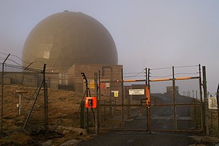
Remote Radar Head Saxa Vord or RRH Saxa Vord, is a Royal Air Force radar station located on the island of Unst, the most northern of the Shetland Islands in Scotland. As of July 2019 it is once more a fully operational radar station, after closure in 2006. The station's motto Praemoneo de Periculis reflects its role. RAF Saxa Vord is further north than Saint Petersburg in Russia, and on the same latitude as Anchorage, Alaska. The station was named after Saxa Vord, which is the highest hill on Unst at 935 ft (285 m). It holds the unofficial British record for wind speed, which in 1992 was recorded at 197 mph (317 km/h) — just before the measuring equipment blew away.

The climate of Scotland is mostly temperate and oceanic, and tends to be very changeable, but rarely extreme. It is warmed by the Gulf Stream from the Atlantic, and given its northerly latitude it is much warmer than areas on similar latitudes, for example Kamchatka in Russia or Labrador in Canada, or Fort McMurray, Canada. Scots sometimes describe weather which is grey and gloomy using the Scots language word dreich.

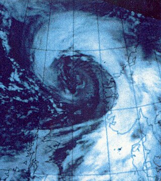
Hurricane Gordon was the first tropical cyclone since 1992 to affect the Azores while retaining tropical characteristics. The eighth tropical storm, third hurricane, and first major hurricane of the 2006 Atlantic hurricane season, Gordon formed on September 10 in the tropical Atlantic Ocean. It gradually matured into a hurricane as it tracked northward, reaching its peak intensity with winds of 195 km/h (121 mph) early on September 14 while located about 925 km (575 mi) southeast of Bermuda. After becoming nearly stationary, Gordon weakened to minimal hurricane status, although it re-intensified after accelerating to the east. It weakened again after moving over cooler waters, and passed through the Azores on September 20. Shortly thereafter, it became an extratropical cyclone and subsequently affected Spain, Ireland, and the United Kingdom.

The British Isles are an archipelago off the northwest coast of Europe, consisting of the islands of Great Britain and Ireland along with smaller surrounding ones. Its position allows dry continental air from Eurasia to meet wetter air from the Atlantic Ocean, which causes the weather to be highly variable, often changing many times during the day. It is defined as a temperate oceanic climate, or Cfb on the Köppen climate classification system. It is significantly warmer than other regions on the same latitude, previously thought to be due to the warmth provided by the Gulf Stream; however, this has been disproven, and most of the mild temperatures have been linked to the Rocky Mountains and the heat storing capabilities of the North Atlantic Ocean. Temperatures do not often switch between great extremes, with warm summers and mild winters.

The climate of Ireland is mild, humid and changeable with abundant rainfall and a lack of temperature extremes. Ireland's climate is defined as a temperate oceanic climate, or Cfb on the Köppen climate classification system, a classification it shares with most of northwest Europe. The island receives generally warm summers and cool winters.
The New Year's Day Storm, known in Scotland as the 'Hogmanay Hurricane', was an intense European windstorm that affected much of northern Scotland and western Norway on 1 January 1992. DNMI estimated the strongest sustained winds and the strongest gusts to have reached 103 mph and 138 mph, respectively. Unofficial records of gusts in excess of 170 knots (87 m/s) were recorded in Shetland, while Statfjord-B in the North Sea recorded wind gusts in excess of 145 knots (75 m/s). There were very few fatalities, mainly due to the rather low population of the islands, the fact that the islanders are used to powerful winds, and because it struck in the morning on a public holiday when people were indoors. In Norway there was one fatality, in Frei, Møre og Romsdal county. There were also two fatalities on Unst in the Shetland Isles. Despite being referred to by some as a 'Hurricane', the storm was Extratropical in origin and is classified as an Extratropical Cyclone.
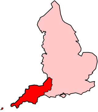
The climate of south-west England is classed as oceanic (Cfb) according to the Köppen climate classification. The oceanic climate is typified by frequent cloudy skies, cool winters with cool summers and precipitation all year round, with more experienced in winter. Annual rainfall is about 1,000 millimetres (39 in) and up to 2,000 millimetres (79 in) on higher ground. Exceptions include areas to the east of high ground ( e.g. Exeter / parts of West Somerset that are subject to a rain shadow effect and annual rainfall is closer to 30 inches.

Hurricane Bawbag, also known as Cyclone Friedhelm was an intense extratropical cyclone which brought hurricane-force winds to Scotland at the beginning of December 2011. The storm also brought prolonged gales and rough seas to the rest of the British Isles, as well as parts of Scandinavia. On 8 December, winds reached up to 165 mph (266 km/h) at elevated areas, with sustained wind speeds of up to 80 mph (130 km/h) reported across populous areas. The winds uprooted trees and resulted in the closure of many roads, bridges, schools and businesses. Overall, the storm was the worst to affect Scotland in 10 years, though a stronger storm occurred less than a month afterwards, on 3 January 2012. Although the follow-up storm was more intense, the winter of 2011–12 is usually remembered for Bawbag among Scots.

The 2013 extreme weather events included several all-time temperature records in Northern and Southern Hemisphere. The February extent of snow cover in Eurasia and North America was above average, while the extent of Arctic ice in the same month was 4.5% below the 1981–2010 average. The Northern Hemisphere weather extremes have been linked to the melting of Arctic sea ice, which alters atmospheric circulation in a way that leads to more snow and ice.
The 2015–16 UK and Ireland windstorm season was the first instance of the United Kingdom's Met Office and Ireland's Met Éireann naming extratropical cyclones. The season started on 10 November with the naming of Storm Abigail and ended on 28 March with the dissipation of Storm Katie. With a total of eleven named storms, the 2015–16 season is the most active to date.

Storm Darwin a European windstorm that Western Europe, particularly Ireland and the United Kingdom on 12 February 2014. The storm brought hurricane-force winds to Ireland the with the Met Office and Met Éireann describing the storm as one of the most significant to affect Ireland, Wales and West England in recent decades. Tini was one of the strongest storms of the 2013–2014 Atlantic winter storms in Europe, and also brought heavy across the UK and Ireland exacerbating the 2013–2014 United Kingdom winter floods, and may have been the most damaging storm of the period.
The 2017–2018 European windstorm season was the third instance of seasonal European windstorm naming. France, Spain and Portugal took part in winter storm naming for the first time this season.

The 2019–20 European windstorm season was the fifth instance of seasonal European windstorm naming in Europe. This is the first season in which the Netherlands participates, joining Ireland's and the United Kingdom's meteorological agencies. The new season's storm names were released on 6 September 2019. In July 2019, it was announced that storm seasons would run from 1 September 2019 to 1 September 2020. The Portuguese, Spanish and French meteorological agencies again collaborated too, joined by the Belgian meteorological agency.

Storm Ciara was a powerful and long-lived extratropical cyclone that was the first of a pair of European windstorms to affect the United Kingdom and Ireland at peak intensity less than a week apart in early February 2020, followed by Storm Dennis a week later. Ciara caused widespread wind and flooding damage across Europe, and at least 13 fatalities.

Storm Dennis was a European windstorm which, in February 2020, became one of the most intense extratropical cyclones ever recorded, reaching a minimum central pressure of 920 millibars. The thirteenth named storm of the 2019–20 European windstorm season, Dennis affected the Republic of Ireland and the United Kingdom less than a week after Storm Ciara, exacerbating the impacts from that storm amidst ongoing flooding in the latter country.

Hurricane Zeta was a late-season major hurricane in 2020 that made landfall on the Yucatán Peninsula and then in southeastern Louisiana, the latest on record to do so at such strength in the United States. Zeta was the record-tying sixth hurricane of the year to make landfall in the United States. The twenty-seventh named storm, twelfth hurricane and fifth major hurricane of the extremely active 2020 Atlantic hurricane season, Zeta formed from a broad area of low pressure that formed in the western Caribbean Sea on October 19. After battling wind shear, the quasi-stationary low organized into Tropical Depression Twenty-Eight on October 24. The system strengthened into Tropical Storm Zeta early on October 25 before becoming a hurricane the next day as it began to move northwestward. Hurricane Zeta made landfall on the Yucatán Peninsula late on October 26 and weakened while inland to a tropical storm, before moving off the northern coast of the peninsula on October 27. After weakening due to dry air entrainment, Zeta reorganized and became a hurricane again, and eventually a Category 2 hurricane, as it turned northeastward approaching the United States Gulf Coast on October 28. It continued to strengthen until it reached its peak intensity as a major Category 3 hurricane with 115-mile-per-hour (185 km/h) sustained winds and a minimum pressure of 970 mbar (28.64 inHg) as it made landfall at Cocodrie, Louisiana, that evening. Zeta continued on through Mississippi and parts of Alabama with hurricane-force winds. Zeta gradually weakened as it accelerated northeastward, and became post-tropical on October 29, as it moved through central Virginia, dissipating shortly afterwards off the coast of New Jersey. After bringing accumulating snow to parts of New England, the extratropical low-pressure system carrying Zeta's remnant energy impacted the United Kingdom on November 1 and 2.

The 2022 United Kingdom heatwaves were part of several heatwaves across Europe and North Africa. The United Kingdom experienced three heatwaves; the first was for three days in June, the second for three days in July, and the third for six days in August. These were periods of unusually hot weather caused by rising high pressure up from the European continent. There were also more grass fires and wildfires than average, and in August a drought was declared in many regions.

Saxa Vord distillery is a Scotch whisky and gin distillery on the island of Unst, part of the Shetland islands. The distillery takes its name from its location immediately south of RAF Saxa Vord, an RAF station and headland. The distillery buildings are adjacent to the SaxaVord Spaceport.
{{cite web}}: CS1 maint: archived copy as title (link)