Related Research Articles

A blizzard is a severe snowstorm characterized by strong sustained winds and low visibility, lasting for a prolonged period of time—typically at least three or four hours. A ground blizzard is a weather condition where snow is not falling but loose snow on the ground is lifted and blown by strong winds. Blizzards can have an immense size and usually stretch to hundreds or thousands of kilometres.

The Northeastern United States blizzard of 1978 was a catastrophic, historic nor'easter that struck New England, New Jersey, Pennsylvania and the New York metropolitan area. The Blizzard of '78 formed on Sunday, February 5, 1978, and broke up on February 7. The storm was initially known as "Storm Larry" in Connecticut, following the local convention promoted by the Travelers Weather Service on television and radio stations there. Snow fell mostly from Monday morning, February 6, to the evening of Tuesday, February 7. Connecticut, Rhode Island, and Massachusetts were hit especially hard by this storm.

The blizzard of 1977 hit Western New York and Southern Ontario from January 28 to February 1 of that year. Daily peak wind gusts ranging from 46 to 69 mph were recorded by the National Weather Service in Buffalo, with snowfall as high as 100 in (254 cm) recorded in areas, and the high winds blew this into drifts of 30 to 40 ft. There were 23 total storm-related deaths in Western New York, with five more in northern New York.
The Great Blizzard of 1978 was a historic winter storm that struck the Ohio Valley and Great Lakes regions of the United States as well as Southern Ontario in Canada from Wednesday, January 25 through Friday, January 27, 1978. It is often cited as one of the most severe blizzards in US history. The third lowest non-tropical atmospheric pressure ever recorded in the mainland United States occurred as the storm passed over Mount Clemens, Michigan, where barometer readings fell to 956.0 mb (28.23 inHg) on January 26.

The Blizzard of 2003, also known as the Presidents' Day Storm II or simply PDII, was a historic and record-breaking snowstorm on the East Coast of the United States and Canada, which lasted from February 14 to February 19, 2003. It spread heavy snow across the major cities of the Northeastern and Mid-Atlantic states, making it the defining snowstorm of the very snowy winter of 2002–2003.

The February 2007 North American blizzard was a massive winter storm that affected most of the eastern half of North America, starting on February 12, 2007 and peaking on Valentine's Day, February 14. The storm produced heavy snowfalls across the midwestern United States from Nebraska to Ohio and produced similar conditions across parts of the northeastern United States, and into Canada in Ontario, Quebec and New Brunswick. Significant sleet and freezing rain fell across the southern Ohio Valley and affected portions of the east coast of the United States, including the cities of Boston, Baltimore, Washington, D.C., New York City and Philadelphia.

The Saskatchewan Blizzard of 2007 was a winter storm that struck northeastern British Columbia, central Alberta and central Saskatchewan on Wednesday, January 10, 2007. The storm hit the city of Saskatoon severely and is considered to be one of the worst storms in Saskatchewan's history. It brought motor vehicle traffic to a standstill, stranded people and shut down many public services. There were two fatalities from the storm.

A blizzard warning is a hazardous weather statement issued by Weather Forecast Offices (WFO) of the National Weather Service (NWS) in the United States, which indicates heavy snowfall accompanied by sustained winds or frequent gusts of 35 mph (56 km/h) or greater are forecast to occur for a minimum of three hours. A blizzard tends to reduce visibilities to 1⁄4 mile (400 m) or less.
The year 2005 saw 25 heavy snowfall days, which is the joint snowiest year with 1876 across the United Kingdom, between the years 1861-2005.
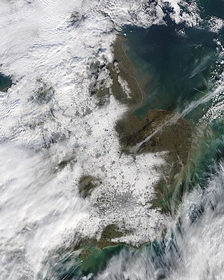
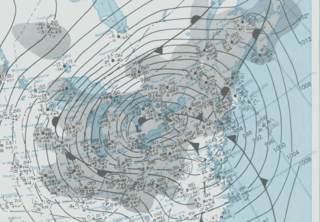
The February 2009 Great Britain and Ireland snowfall was a prolonged period of snowfall that began on 1 February 2009. Some areas experienced their largest snowfall levels in 18 years. Snow fell over much of Western Europe. The United Kingdom's Met Office and Ireland's Met Éireann issued severe weather warnings in anticipation of the snowfall. More than 30 centimetres (12 in) of snow fell on parts of the North Downs and over 20 cm (8 in) in parts of the London area. Such snow accumulation is uncommon in London. On the morning of 6 February the majority of Great Britain and Ireland had snow cover, with the area surrounding the Bristol Channel being most affected – 55 cm (22 in) had settled overnight around Okehampton, Devon, South West England with similar depths in South Wales. In Ireland the highest totals were recorded around East Kildare and County Wicklow where up to 28 cm (11 in) fell around Naas, County Kildare and even more along the Wicklow Mountains. The last time such widespread snowfall affected Britain was in February 1991. On the 2nd a total of 32 cm (13 in) had fallen in Leatherhead, Surrey just south of the M25. Also 30 cm (12 in) had fallen over the South Downs and 26 cm (10 in) in higher areas of Brighton.

The winter of 2009–2010 in Europe was unusually cold. Globally, unusual weather patterns brought cold, moist air from the north. Weather systems were undergoing cyclogenesis from North American storms moving across the Atlantic Ocean to the west, and saw many parts of Europe experiencing heavy snowfall and record-low temperatures. This led to a number of deaths, widespread transport disruption, power failures and postponed sporting events.

The winter of 2009–10 in the United Kingdom was a meteorological event that started on 16 December 2009, as part of the severe winter weather in Europe. January 2010 was provisionally the coldest January since 1987 in the UK. A persistent pattern of cold northerly and easterly winds brought cold, moist air to the United Kingdom with many snow showers, fronts and polar lows bringing snowy weather with it.

The February 9–10, 2010 North American blizzard was a winter and severe weather event that afflicted the Midwest, Mid-Atlantic and New England regions of the United States between February 9–11, 2010, affecting some of the same regions that had experienced a historic Nor'easter three days prior. The storm brought 10 to 20 inches of snow across a wide swath from Washington, DC to New York City, with parts of the Baltimore metro area receiving more than 20 inches (51 cm). This storm began as a classic "Alberta clipper", starting out in Canada and then moving southeast, and finally curving northeast while rapidly intensifying off the New Jersey coast, forming an eye. The National Weather Service, in an interview with The Baltimore Sun's weather reporter Frank Roylance, likened this storm to a Category 1 hurricane. Forecasters told Roylance that "Winds topped 58 mph over part of the Chesapeake Bay, and 40 mph gusts were common across the region as the storm's center deepened and drifted slowly along the mid-Atlantic coast". This storm system, in conjunction with the first storm 3 days prior, has been nicknamed Snoverkill.
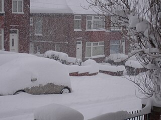
The winter of 2010–11 was a weather event that brought heavy snowfalls, record low temperatures, travel chaos and school disruption to the islands of Great Britain and Ireland. It included the United Kingdom's coldest December since Met Office records began, with a mean temperature of −1 °C (30 °F), breaking the previous record of 0.1 °C (32.2 °F) in December 1981. It was also the second coldest December in the narrower Central England Temperature (CET) record series which began in 1659, falling 0.1 °C short of the all-time record set in 1890. Although there are no xx, December 2010 is thought to be colder than December 1890 over the United Kingdom as a whole, as Scotland was up to 2 °C warmer than England. Hence, it is thought to be the coldest December across Great Britain since before 1659.
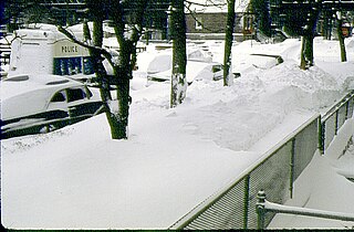
The Chicago blizzard of 1967 struck northeast Illinois and northwest Indiana on January 26–27, 1967, with a record-setting 23 inches (58 cm) snow fall in Chicago and its suburbs before the storm abated the next morning. As of 2024, it remains the greatest snowfall in one storm in Chicago history. As the blizzard was a surprise during the day with people already at work or school, it stopped the city for a few days as people dug out. "The storm was a full-blown blizzard, with 50 mph-plus northeast wind gusts creating drifts as high as 15 feet."

The 2011 Groundhog Day blizzard was a powerful and historic winter storm that affected large swaths of the United States and Canada from January 31 to February 2, 2011, especially on Groundhog Day. During the initial stages of the storm, some meteorologists predicted that the system would affect over 100 million people in the United States. The storm brought cold air, heavy snowfall, blowing snow, and mixed precipitation on a path from New Mexico and northern Texas to New England and Eastern Canada. The Chicago area saw 21.2 inches (54 cm) of snow and blizzard conditions, with winds of over 60 mph (100 km/h). With such continuous winds, the blizzard continued to the north and affected Eastern and Atlantic Canada. Blizzard conditions affected many other large cities along the storm's path, including Tulsa, Oklahoma City, Kansas City, St. Louis, Springfield, El Paso, Las Cruces, Des Moines, Milwaukee, Detroit, Indianapolis, Dayton, Cleveland, New York City, New York's Capital District, and Boston. Many other areas not normally used to extreme winter conditions, including Albuquerque, Dallas and Houston, experienced significant snowfall or ice accumulation. The central Illinois National Weather Service in Lincoln, Illinois, issued only their fourth blizzard warning in the forecast office's 16-year history. Snowfall amounts of 20 to 28 inches were forecast for much of Northern and Western Illinois.

The January 2016 United States blizzard produced up to 3 ft (91 cm) of snow in parts of the Mid-Atlantic and Northeastern United States during January 22–24, 2016. A weather system, evolving from a shortwave trough that formed in the Pacific Northwest on January 19, consolidated into a defined low-pressure area on January 21 over Texas. Meteorologists indicated that a resultant storm could produce more than 2 ft (61 cm) of snow across a wide swath of the Mid-Atlantic region and could "paralyze the eastern third of the nation", and regarded it as a "potentially historic blizzard". Winter weather expert Paul Kocin described the blizzard as "kind of a top-10 snowstorm".
The Western European winter storm March 2013 was a late season snow event that affected Southern England, Belgium, Northern France and Germany on 12 March 2013. It was notable for its effects particularly in Northern France where snowfall totals reached 24 in (61 cm).

Between November 2019 and February 2020, severe winter flooding occurred across the United Kingdom. The first wave of flooding occurred in November 2019, mainly affecting Yorkshire and the Humber, the East Midlands and the West Midlands. Further isolated flooding incidents were reported in December and January, before the second main wave of flooding, caused by Storms Ciara and Dennis, occurred in February 2020. The excessive rainfall resulted in the wettest February since records began, in 1766, in England and Wales with an average of 169.6 millimetres (6.68 in) falling across the regions, beating the record from 1833.
The Great Lakes Blizzard of January 1971 affected almost the entire Great Lakes region of North America, as well as the western St. Lawrence Valley and northern New England between January 25 and 28, 1971 before a second severe snowstorm hit many of the same areas between January 28 and 31, 1971. The areas that felt the fiercest effects of the dual storms, that being moderate or heavy snow, sustained high winds, and zero visibility due to blowing snow, included southern Wisconsin, most of Michigan, Southern Ontario, northeastern Ohio, northwestern Pennsylvania, most of upstate New York and Southern Quebec, while northern Wisconsin, northern Indiana, northeastern Ontario, and northern Vermont experienced blizzard conditions from the first of the storms.
References
- ↑ "16 to 21 January 1995 Reanalysis archives". wetterzentrale. Retrieved 9 February 2019.
- ↑ "24 to 29 January 1995 Reanalysis archives". wetterzentrale. Retrieved 9 February 2019.
- 1 2 "The British weather in January". Trevor Harley. Retrieved 9 February 2019.
- 1 2 3 Grace Newton (27 February 2018). "The snowstorm that brought chaos to Yorkshire and killed six stranded drivers". Yorkshire Post . Retrieved 9 February 2019.
- 1 2 3 4 Jonathon Foster (27 January 1995). "Four killed as blizzards sweep the North". The Independent. Retrieved 9 February 2019.