Bangladesh is a densely populated, low-lying, mainly riverine country located in South Asia with a coastline of 580 km (360 mi) on the northern littoral of the Bay of Bengal. The delta plain of the Ganges (Padma), Brahmaputra (Jamuna), and Meghna Rivers and their tributaries occupy 79 percent of the country. Four uplifted blocks occupy 9 percent and steep hill ranges up to approximately 1,000 metres (3,300 ft) high occupy 12 percent in the southeast and in the northeast. Straddling the Tropic of Cancer, Bangladesh has a tropical monsoon climate characterised by heavy seasonal rainfall, high temperatures, and high humidity. Natural disasters such as floods and cyclones accompanied by storm surges periodically affect the country. Most of the country is intensively farmed, with rice the main crop, grown in three seasons. Rapid urbanisation is taking place with associated industrial and commercial development. Exports of garments and shrimp plus remittances from Bangladeshis working abroad provide the country's three main sources of foreign exchange income.

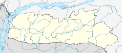
Meghalaya is a state in northeast India. Meghalaya was formed on 21 January 1972 by carving out two districts from the state of Assam: (a) the United Khasi Hills and Jaintia Hills and (b) the Garo Hills. The estimated population of Meghalaya in 2014 was 3,211,474. Meghalaya covers an area of approximately 22,429 square kilometres, with a length-to-breadth ratio of about 3:1.
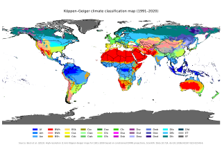
The Köppen climate classification is one of the most widely used climate classification systems. It was first published by German-Russian climatologist Wladimir Köppen (1846–1940) in 1884, with several later modifications by Köppen, notably in 1918 and 1936. Later, German climatologist Rudolf Geiger (1894–1981) introduced some changes to the classification system in 1954 and 1961, which is thus sometimes called the Köppen–Geiger climate classification.
Northeast India, officially the North Eastern Region (NER), is the easternmost region of India representing both a geographic and political administrative division of the country. It comprises eight states—Arunachal Pradesh, Assam, Manipur, Meghalaya, Mizoram, Nagaland and Tripura, and the "brother" state of Sikkim.

The climate of India consists of a wide range of weather conditions across a vast geographic scale and varied topography. Based on the Köppen system, India hosts six major climatic sub types, ranging from arid deserts in the west, alpine tundra and glaciers in the north, and humid tropical regions supporting rain forests in the southwest and the island territories. Many regions have starkly different microclimates, making it one of the most climatically diverse countries in the world. The country's meteorological department follows the international standard of four seasons with some local adjustments: winter, summer, monsoon or rainy season, and a post-monsoon period.
Mawsynram is a town in the East Khasi Hills district of Meghalaya state in Northeastern India, 69 kilometres from Shillong, the state capital. Mawsynram receives the highest rainfall in India. It is reportedly the wettest place on Earth, with an average annual rainfall of 11,872 millimetres (467.4 in). According to the Guinness Book of World Records, Mawsynram received 26,000 millimetres (1,000 in) of rainfall in 1985. Mawsynram received 745.2 mm of rainfall on 19 August 2015, probably the highest rainfall received by the town in recent times. On 17 June 2022, Mawsynram set a new record by receiving 1003.6 mm in a span of 24 hours which has now become its highest single day record for the month of June and for its all-time single day record, beating its former record of 944.7 mm on 7 June 1966.

Barasat is a city and a municipality of North 24 Parganas district in the state of West Bengal, India. It is the headquarters of Barasat Sadar subdivision. It is close to Kolkata and a part of the area covered by Kolkata Metropolitan Development Authority (KMDA). Located in the Ganges delta, Barasat is a regional transportation hub as a rail and road junction. National Highway 12, NH 112, Taki Road and Barrackpore-Barasat Road are the main connectivity links to the city.
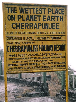
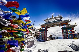
Cherrapunji or Sohra is a sub-divisional town East Khasi Hills district in the Indian state of Meghalaya. It was the traditional capital of ka hima Sohra.

Kurigram District is a district of Bangladesh in the Rangpur Division. The district is located in northern Bangladesh along the country's border with India. Under Indian rule, the area was organized as a mahakuma and was not established as a district until 1984.
The Satkhira District is a district in southwestern Bangladesh and is part of Khulna Division. It lies along the border with West Bengal, India. It is on the bank of the Arpangachhia River. The largest city and headquarter of this district is Satkhira.
Kapren is a city and a municipality in Bundi district in the Indian state of Rajasthan.
Sanwer is a Nagar panchayat in Indore district in the Indian state of Madhya Pradesh. It is situated between two major cities of Madhya Pradesh- Indore and Ujjain.
Ainapur is a town in the southern state of Karnataka, India. It is located in the Athani taluk of Belgaum district in Karnataka. Ainapur village is famous for Peda, the village situated near river Krishna. Sugarcane is the chief cultivated crop and Kannada is the primary spoken language.
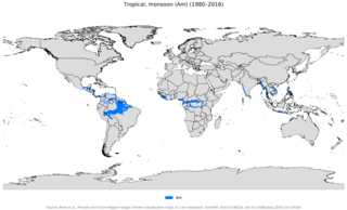
An area of tropical monsoon climate is a tropical climate subtype that corresponds to the Köppen climate classification category Am. Tropical monsoon climates have monthly mean temperatures above 18 °C (64 °F) in every month of the year and a dry season. The tropical monsoon climate is the intermediate climate between the wet AF and the drier Aw.
Mohare is a village in Bailhongal Taluk, Belagavi District of Karnataka, India. It is located near the state border with Maharashtra, about 26 kilometres east of the district seat Belgaum, and 16 kilometres northwest of the taluk seat Bailhongal. As of 2011, it has a total population of 2,365.

The climate of Asia is dry across its southwestern region. Some of the largest daily temperature ranges on Earth occur in the western part of Asia. The monsoon circulation dominates across the southern and eastern regions, due to the Himalayas forcing the formation of a thermal low which draws in moisture during the summer. The southwestern region of the continent experiences low relief as a result of the subtropical high pressure belt; they are hot in summer, warm to cool in winter, and may snow at higher altitudes. Siberia is one of the coldest places in the Northern Hemisphere, and can act as a source of arctic air mass for North America. The most active place on Earth for tropical cyclone activity lies northeast of the Philippines and south of Japan, and the phase of the El Nino-Southern Oscillation modulates where in Asia landfall is more likely to occur. Many parts of Asia are being impacted by climate change.
Jhuruli is a village in Basirhat II CD Block in Basirhat subdivision of North 24 Parganas district in the Indian state of West Bengal.
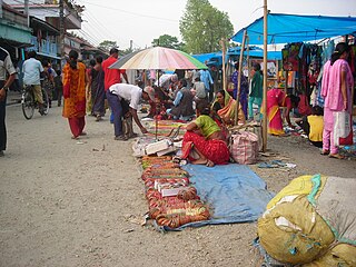
Haat हाट or hat, also haat bazaar, is an open-air market that serves as a trading venue for local people in rural areas and towns mainly in Bangladesh, Bhutan, Nepal and India. Haat bazaars are conducted on a regular basis, usually once, twice or thrice a week, and in some places once every fortnight. At times, haat bazaars are organized in a different manner, to support or promote trading by and with rural people. In addition to providing trading opportunities, haat bazaars serve as meeting places, rural settlements come up around the haats which gradually grow into towns.
The Republic of India shares borders with several sovereign countries; it shares land borders with China, Bhutan, Nepal, Pakistan, Bangladesh and Myanmar. Bangladesh Myanmar and Pakistan share both land borders as well as maritime borders, while Sri Lanka shares only a maritime border through Ram Setu. India's Andaman and Nicobar Islands share a maritime border with Thailand, Myanmar, and Indonesia.

India–Bangladesh border haat is a Haat or a trading post on Bangladesh–India border, jointly organised by the governments of Bangladesh and India, held one day each week. It is not only a market for locals and tourists for buying daily commodities but also a reunion spot for families living on both sides of the international border.