Ballylinney or Ballylinny (from Irish : Baile Linne, meaning 'homestead of the pond') [1] is a small village and townland near Ballyclare in County Antrim, Northern Ireland. It is part of Antrim and Newtownabbey Borough Council.
Ballylinney or Ballylinny (from Irish : Baile Linne, meaning 'homestead of the pond') [1] is a small village and townland near Ballyclare in County Antrim, Northern Ireland. It is part of Antrim and Newtownabbey Borough Council.
The closest local school is called Thompson Primary School.
Donegore is the name of a hill, a townland, a small cluster of residences, and a civil parish in the historic barony of Antrim Upper, County Antrim, Northern Ireland. Donegore lies approximately 5 miles (8 km) east of Antrim town. 154 acres of the townland lies in the civil parish of Grange of Nilteen.
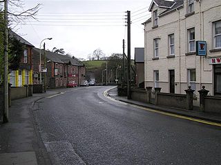
Cullybackey or Cullybacky is a large village in County Antrim, Northern Ireland. It lies 3 miles north-west of Ballymena, on the banks of the River Main, and is part of Mid and East Antrim district. It had a population of 2,569 people in the 2011 Census.

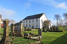
Gracehill is a village in County Antrim, Northern Ireland. It lies about 3 km from Ballymena and is in the townland of Ballykennedy. It is part of the Borough of Mid & East Antrim.

Aghagallon is a small village and civil parish in County Antrim, Northern Ireland. It is about three miles northeast of Lurgan and had a population of 824 in the 2001 Census.

Ballyrobert is a small village in County Antrim, Northern Ireland. It is about 4 km south of Ballyclare and has developed around the junction of the Ballyrobert Road and the Mossley Road/The Longshot. It had a population of 587 people in the 2001 Census. It was within the Newtownabbey Borough Council area which became the Antrim and Newtownabbey Borough Council in 2015.
Kells is a village near Ballymena in County Antrim, Northern Ireland, that also encompasses the neighbouring village of Connor. As such it is also known as Kells and Connor in which they share a primary school, library, development association etc. It is in Mid and East Antrim District Council. Kells and Connor had a population of 2,053 people in the 2011 Census.

Drumbeg is a small village, townland and civil parish on the south bank of the River Lagan in County Down, Northern Ireland. The village is covered by the Lisburn City Council area and forms part of the suburban fringe of Belfast.

Glenavy is a village and civil parish in County Antrim, Northern Ireland, 17 kilometres north west of Lisburn on the banks of the Glenavy River. In the 2011 Census it had a population of 5,697 people. In early documents it was known as Lenavy.
Maghaberry or Magaberry is a village and townland in County Antrim, Northern Ireland. It is 9 kilometres (5.6 mi) west of Lisburn and 4 kilometres (2.5 mi) north of Moira. In the 2011 Census it had a population of 4,716 people. It is one of the biggest villages within the Lisburn and Castlereagh City Council area.

Cargan is a hamlet and townland in County Antrim, Northern Ireland. It lies at the foot of Slievenanee in Glenravel – locally known as "The Tenth Glen" along with the more widely known nine Glens of Antrim. It is part of Mid and East Antrim district. It had a population of 588 people in the 2011 Census.

Clogh, also spelt as Clough, is a small village in County Antrim, Northern Ireland, 9 miles from Ballymena. It is situated within the Glenravel ward of the Braid electoral area of Mid and East Antrim District Council. It had a population of 220 people in the 2011 Census.
Martinstown is a small village in County Antrim, Northern Ireland. Located 6 miles from Ballymena, it is situated in Glenravel, locally known as "The Tenth Glen", alongside the widely known nine Glens of Antrim.

Glenoe or Gleno is a hamlet in County Antrim, Northern Ireland. It is halfway between Larne and Carrickfergus. In the 2001 Census, it had a population of 87 people. Glenoe is in the Mid and East Antrim Borough Council area.
Mill Bay is a small village on Islandmagee in County Antrim, Northern Ireland. It sits by the tiny Carnspindle Bay, within the townland of Carnspindle. It is in the Larne Borough Council area. In the 2011 Census it had a population of 103 people. .
Mounthill is a small village in County Antrim, Northern Ireland, near Larne. In the 2011 Census, it had a population of 114 people. It is situated in the Larne Borough Council area.

Straid is a small village in County Antrim, Northern Ireland, about three miles east of Ballyclare, and about six miles inland from Carrickfergus. It lies at the centre of the townland of Straidlands, in the Civil Parish of Ballynure within the Antrim and Newtownabbey Borough Council area, and in the former barony of Belfast Lower. The village has a congregational church, an Orange hall, and a primary school.
Aughafatten or Aghafatten is a small village and townland between Carnlough and Broughshane in County Antrim, Northern Ireland. It is in Mid and East Antrim District Council and part of the North Antrim constituency for local and European elections. It enjoys an excellent view of Slemish mountain.

Newtowncrommelin is a small village and civil parish in County Antrim, Northern Ireland. It lies 8 miles north-northeast of Ballymena and is in the Mid and East Antrim Borough Council area. The village of Newtowncrommelin was founded in the townland of Skerry.
Coordinates: 54°44′13″N5°59′50″W / 54.73694°N 5.99722°W
| | This article related to the geography of County Antrim, Northern Ireland is a stub. You can help Wikipedia by expanding it. |
