
Moyle District Council was a local council in County Antrim in the northeast of Northern Ireland. It merged with Ballymoney Borough Council, Coleraine Borough Council and Limavady Borough Council in May 2015 under local government reorganisation to become Causeway Coast and Glens District Council.

Glenarm is a village in County Antrim, Northern Ireland. It lies on the North Channel coast north of the town of Larne and the village of Ballygalley, and south of the village of Carnlough. It is situated in the civil parish of Tickmacrevan and the historic barony of Glenarm Lower. It is part of Mid and East Antrim Borough Council and had a population of 568 people in the 2011 Census. Glenarm takes its name from the glen in which it lies, the southernmost of the nine Glens of Antrim.

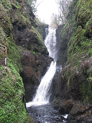
Glenariff or Glenariffe is a valley in County Antrim, Northern Ireland. It is one of the Glens of Antrim. Like other glens in that area, it was shaped during the Ice Age by giant glaciers.
Balnamore is a small village in County Antrim, Northern Ireland. It is within the townland of Ballynacree-Skein and lies 3 km west of Ballymoney. It is part Causeway Coast and Glens District Council. Historically it was known as Ballinamore.
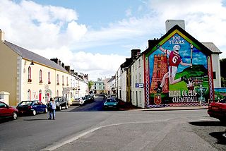
Cushendall, formerly known as Newtownglens, is a coastal village and townland in County Antrim, Northern Ireland. It is located in the historic barony of Glenarm Lower and the civil parish of Layd, and is part of Causeway Coast and Glens district.

Portballintrae is a small seaside village in County Antrim, Northern Ireland. It is four miles east of Portrush and two miles west of the Giant's Causeway. In the 2001 Census it had a population of 734 people, a decline of 10% compared to 1991. It lies within the Causeway Coast and Glens District Council area.

Dál nAraidi or Dál Araide, sometimes latinised as Dalaradia or anglicised as Dalaray, was a Cruthin kingdom, or possibly a confederation of Cruthin tribes, in north-eastern Ireland during the Middle Ages. It was part of the over-kingdom of Ulaid, and its kings often contended with the Dál Fiatach for the over-kingship of the province. At its greatest extent, the borders of Dál nAraidi roughly matched those of County Antrim, and they seemed to occupy the same area as the earlier Robogdii of Ptolemy's Geography, a region shared with Dál Riata. Their capital was Ráth Mór outside Antrim, and their eponymous ancestor is claimed as being Fiachu Araide.

Waterfoot or Glenariff is a small coastal village in County Antrim, Northern Ireland. It is at the foot of Glenariff, one of the Glens of Antrim, within the historic barony of Glenarm Lower and the civil parishes of Ardclinis and Layd. The village is in the townland of Warren, 16 miles (26 km) north-east of Ballymena. The 2001 Census recorded a population of 504 inhabitants.

Cargan is a hamlet and townland in County Antrim, Northern Ireland. It lies at the foot of Slievenanee in Glenravel – locally known as "The Tenth Glen" along with the more widely known nine Glens of Antrim. It is part of Mid and East Antrim district. It had a population of 588 people in the 2011 Census.

Clogh, also spelt as Clough, is a small village in County Antrim, Northern Ireland, 9 miles from Ballymena. It is situated within the Glenravel ward of the Braid electoral area of Mid and East Antrim District Council. It had a population of 220 people in the 2011 Census.
Martinstown is a small village in County Antrim, Northern Ireland. Located 6 miles from Ballymena, it is situated in Glenravel, locally known as "The Tenth Glen", alongside the widely known nine Glens of Antrim.
Glenariff Forest Park is an 1185 hectare forest in County Antrim, Northern Ireland. It is part of Glenariff glen itself. The forest is managed by the Northern Ireland Forest Service, the state body responsible for forestry in the province, which is part of the Department of Agriculture, Environment and Rural Affairs.

The River Bush is a river in County Antrim, Northern Ireland. The River Bush is 33.5 miles (53.9 km) long. The river's source is in the Antrim Hills at 480m. From there the river flows northwest, with a bend at the town of Armoy. It then flows west, passing through Stranocum, and then bends north, passing through Bushmills before reaching the sea at Portballintrae on the North Antrim coast. It flows through a fertile valley devoted to grassland-based agriculture with limited arable cropping. The underlying geology is basalt and the water is slightly alkaline with magnesium making an unusually large contribution to total hardness. The river supports indigenous stocks of Atlantic salmon and brown trout. Saint Columb's Rill, which is a tributary of the river, is the source of water used for distilling Bushmills whiskey.

Randalstown is a townland and small town in County Antrim, Northern Ireland, between Antrim and Toome. It has a very prominent disused railway viaduct and lies beside Lough Neagh and the Shane's Castle estate. The town is bypassed by the M22 motorway with junctions at both the eastern and western ends of the town. It had a population of 5,151 people in the 2021 Census.

The River Dun, also known as the Glendun River is a river in County Antrim, Northern Ireland. It runs through Glendun, one of the nine Glens of Antrim. The river is named after its brown colour, which comes from the peat bogs at its source on the slopes of Slievenanee on the Antrim Plateau. The source of the river is a few hundred metres from that of the River Bush, which flows north-east to meet the sea at Bushmills. Cushendun is a small coastal resort town lying at the mouth of the River Dun and Glendun.

Newtowncrommelin is a small village and civil parish in County Antrim, Northern Ireland. It lies 8 miles north-northeast of Ballymena and is in the Mid and East Antrim Borough Council area. The village of Newtowncrommelin was founded in the townland of Skerry.

Red Bay Castle is situated in County Antrim, Northern Ireland, on a headland projecting into the sea north of Glenariff situated on the road to Cushendall.

Ardclinis is a civil parish and townland in County Antrim, Northern Ireland. It is situated in the historic barony of Glenarm Lower.
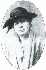
Margaret Emmeline Dobbs was an Irish scholar and playwright, best known for her work to preserve the Irish language.


