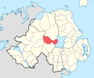
Loughinsholin is a barony in County Londonderry, Northern Ireland. Its southeast borders the northwest shore of Lough Neagh, and itself is bordered by seven other baronies: Dungannon Upper to the south; Strabane Upper to the west; Keenaght and Coleraine to the north; Kilconway, Toome Upper, and Toome Lower to the east. It was formed largely on the extent of the northern part of the medieval Irish túath of Uí Tuirtri.
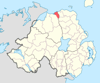
The North East Liberties of Coleraine is a barony in County Londonderry, Northern Ireland. It borders the north-Londonderry coastline, and is bordered by three other baronies: Coleraine to the west; Dunluce Lower to the north-east; Dunluce Upper to the south-east. The North East Liberties of Coleraine formed the north-western part of the medieval territory known as the Route.

Antrim Lower is a barony in County Antrim, Northern Ireland. It is bordered by six other baronies: Antrim Upper to the south; Toome Upper to the south-west; Toome Lower to the west; Kilconway to the north-west; Glenarm Lower to the north-east; and Glenarm Upper to the east. The River Braid flows through this barony.

Glenarm Upper is a barony in County Antrim, Northern Ireland. To its east runs the east-Antrim coast, and it is bordered by four other baronies: Glenarm Lower to the north; Antrim Lower to the west; Antrim Upper to the south-west; and Belfast Lower to the south. Chaine Tower, situated at the entrance to Larne Lough, is located within Glenarm Upper.

Glenarm Lower is a barony in County Antrim, Northern Ireland. To its east runs the east-Antrim coast, and it is bordered by five other baronies: Cary to the north; Dunluce Lower and Kilconway to the west; Antrim Lower to the south-west; and Glenarm Upper to the south-east.

Cary is a historic barony in County Antrim, Northern Ireland. To its north is the north-Antrim coast, and it is bordered by three other baronies: Dunluce Lower to the west; Dunluce Upper to the south; and Glenarm Lower to the south-east. The Giant's Causeway is situated on the north coast of Cary. Dunineny Castle lies in the civil parish of Ramoan within this barony.

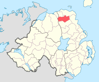
Dunluce Lower is a barony in County Antrim, Northern Ireland. To its north runs the north-Antrim coast, and it is bordered by three other baronies: Dunluce Upper to the south, Cary to the east, and the North East Liberties of Coleraine to the west. The River Bush flows through this barony. Dunluce Lower also formed the northern part of the medieval territory known as the Route.
Dunluce Upper is a barony in County Antrim, Northern Ireland. It is bordered by six other baronies: Dunluce Lower to the north; Cary to the north-east; North East Liberties of Coleraine to the north-west; Coleraine to the west; Kilconway to the south; and Glenarm Lower to the east. Dunluce Upper also formed part of the medieval territory known as the Route.

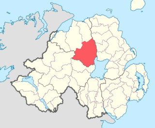
Kilconway is a barony in County Antrim, Northern Ireland. It is bordered by six other baronies: Dunluce Upper to the north; Glenarm Lower to the east; Antrim Lower to the south-east; Toome Lower to the south; Loughinsholin to the south-west; and Coleraine to the north-east. Kilconway also formed part of the medieval territory known as the Route. Springmount Bog is located within the barony.

Belfast Lower is a barony in County Antrim, Northern Ireland. To its east lies the east-Antrim coast and Belfast Lough, and it is bordered by four other baronies: Belfast Upper to the south, Carrickfergus to the east, Antrim Upper to the west; Glenarm Upper to the north. The Forth and Milewater rivers both flow through Belfast Lower, with Larne harbour also situated in the barony.

Antrim Upper is a barony in County Antrim, Northern Ireland. It is bordered by six other baronies: Antrim Lower to the north; Toome Upper to the west; Massereene Lower to the south-west; Belfast Upper to the south; Belfast Lower to the south-east; and Glenarm Upper to the east.

Belfast Upper is a barony in County Antrim, Northern Ireland. To its east lies the barony of Belfast and Belfast Lough, and it is bordered by five other baronies: Belfast Lower to the north-east; Antrim Upper to the north-west; Massereene Lower to the west; Massereene Upper to the south-west; and Castlereagh Upper to the south. The Forth River flows through both Belfast Upper and Lower. The most prominent hills in the barony are Black Hill and Lyle's Hill.

Massereene Lower is a barony in County Antrim, Northern Ireland. To its west lies Lough Neagh, and it is bordered by four other baronies: Massereene Upper to the south; Belfast Upper to the east; Antrim Upper to the north; and Toome Upper to the north-west.
Massereene Upper is a barony in southwest County Antrim, Northern Ireland. It roughly matches the former district of Killultagh. It includes settlements such as Crumlin, Glenavy, Lower Ballinderry, Maghaberry and Aghalee. To its east lies Belfast Lough, and it is bordered by four other baronies: Massereene Lower to the north; Belfast Upper to the east; Castlereagh Upper to the south-east; and Iveagh Lower, Lower Half to the south-west.

Toome Lower is a barony in County Antrim, Northern Ireland. It is bordered by four other baronies: Toome Upper to the south; Antrim Lower to the east; Kilconway to the north; and Loughinsholin to the west. Toome Lower also formed part of the medieval territories known as the Route and Clandeboye.

Strabane Upper is a barony in County Tyrone, Northern Ireland. It is bordered by six other baronies: Tirkeeran and Keenaght to the north; Loughinsholin and Dungannon Upper to the east; Omagh East to the south; and Strabane Lower to the west.
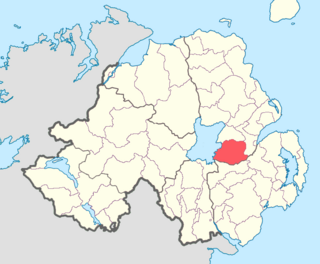
Dungannon Upper is a barony in County Tyrone, Northern Ireland. It was created in 1851 with the splitting of the barony of Dungannon. Lough Neagh runs along its eastern boundary, and it is bordered by four other baronies: Dungannon Middle to the south; Loughinsholin to the north; Strabane Upper to the north-west; and Omagh East to the south-west.

Armagh is a barony in County Armagh, Northern Ireland. It lies in the west of the county, bordering County Tyrone with its north-western boundary, and bordering the Republic of Ireland with its southern boundary. It is bordered by five other baronies in Northern Ireland: Tiranny to the west, Dungannon Middle to the north-west, Oneilland West to the north-east, Fews Lower to the east, and Fews Upper to the south-east. It also borders to the south the barony of Cremorne in the Republic of Ireland.

Oneilland West is a barony in County Armagh, Northern Ireland. It is also called Clancann, after the Mac Cana clan. It lies in the north of the county on the south-western shore of Lough Neagh and the border of County Tyrone. Oneilland West is bordered by five other baronies: Armagh to the west; Dungannon Middle to the north-west; Oneilland East to the north-east; Orior Lower to the south-east; and Kinelarty to the south.

Orior Lower is a barony in County Armagh, Northern Ireland. It lies in the east of the county and borders County Down with its eastern boundary. It is bordered by seven other baronies: Fews Upper to the south-west; Fews Lower to the west; Oneilland West to the north-west; Oneilland East to the north; Iveagh Lower, Lower Half to the north-east; Iveagh Upper, Upper Half to the east; and Orior Upper to the south. A small enclave of Orior Lower resides in the east of Orior Upper.

