
County Antrim is one of the six counties of Northern Ireland, located within the historic province of Ulster. Adjoined to the north-east shore of Lough Neagh, the county covers an area of 3,086 square kilometres (1,192 sq mi) and has a population of 651,321, as of the 2021 census. County Antrim has a population density of 211 people per square kilometre or 546 people per square mile. It is also one of the thirty-two traditional counties of Ireland.

Larne is a town on the east coast of County Antrim, Northern Ireland, with a population of 18,853 at the 2021 census. It is a major passenger and freight roll-on roll-off port. Larne is administered by Mid and East Antrim Borough Council. Together with parts of the neighbouring districts of Antrim and Newtownabbey and Causeway Coast and Glens, it forms the East Antrim constituency for elections to the Westminster Parliament and Northern Ireland Assembly. The civil parish is in the historic barony of Glenarm Upper.

The Northern Counties Committee (NCC) was a railway that served the north-east of Ireland. It was built to Irish gauge but later acquired a number of 914 mm narrow gauge lines. It had its origins in the Belfast and Ballymena Railway which opened to traffic on 11 April 1848.

Lough Foyle, sometimes Loch Foyle, is the estuary of the River Foyle, on the north coast of Ireland. It lies between County Londonderry in Northern Ireland and County Donegal in the Republic of Ireland. Sovereignty over the waters has been in dispute since the Partition of Ireland.
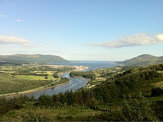
Carlingford Lough is a glacial fjord or sea inlet in northeastern Ireland, forming part of the border between Northern Ireland to the north and the Republic of Ireland to the south. On its northern shore is County Down, the Mourne Mountains, and the town of Warrenpoint; on its southern shore is County Louth, the Cooley Mountains and the village of Carlingford. The Newry River flows into the loch from the northwest.

Islandmagee is a peninsula and civil parish on the east coast of County Antrim, Northern Ireland, located between the towns of Larne and Whitehead. It is part of the Mid and East Antrim Borough Council area and is a sparsely populated rural community with a long history since the mesolithic period. The population is approximately 2,500. In the early medieval period it was known as Semne, a petty-kingdom within Ulaid.

Greenisland is a town in County Antrim, Northern Ireland. It lies 7 miles north-east of Belfast and 3 miles south-west of Carrickfergus. The town is on the coast of Belfast Lough and is named after a tiny islet to the west, the Green Island.

Whitehead is a large seaside village on the east coast of County Antrim, Northern Ireland, lying almost midway between the towns of Carrickfergus and Larne. It lies within the civil parish of Templecorran, the historic barony of Belfast Lower, and is part of Mid and East Antrim Borough Council. Before the Plantation of Ulster its name was recorded as both Whitehead and Kinbaine.

Belfast Lough is a large, intertidal sea inlet on the east coast of Northern Ireland. At its head is the city and port of Belfast, which sits at the mouth of the River Lagan. The lough opens into the North Channel and connects Belfast to the Irish Sea.

Glynn is a small village and civil parish in the Mid and East Antrim Borough Council area of County Antrim, Northern Ireland. It lies a short distance south of Larne, on the shore of Larne Lough. As of the 2011 census, the Glynn ward had a population of 2,027 people.

Dál nAraidi or Dál Araide, sometimes latinised as Dalaradia or anglicised as Dalaray, was a Cruthin kingdom, or possibly a confederation of Cruthin tribes, in north-eastern Ireland during the Middle Ages. It was part of the over-kingdom of Ulaid, and its kings often contended with the Dál Fiatach for the over-kingship of the province. At its greatest extent, the borders of Dál nAraidi roughly matched those of County Antrim, and they seemed to occupy the same area as the earlier Robogdii of Ptolemy's Geography, a region shared with Dál Riata. Their capital was Ráth Mór outside Antrim, and their eponymous ancestor is claimed as being Fiachu Araide.

The Belfast–Larne line, or Larne line, is a railway line in Northern Ireland, operated by Northern Ireland Railways. It runs as double track along the majority of its route north along the scenic east Antrim coastline from Belfast to the coastal seaport town of Larne, serving commuters and ferry passengers.

The A6 road in Northern Ireland runs for 71.4 miles (114.9 km) from Belfast to Derry, via County Antrim and County Londonderry. While stretches of the road before Randalstown have now been superseded by a motorway, the A6 remains one of the most important arterial routes in Northern Ireland, connecting its two largest cities and urban areas. Between Randalstown and Derry, the road forms part of European route E16.

Portmore Lough is a small lake in southwest County Antrim, Northern Ireland that drains water into nearby Lough Neagh. It is roughly circular and covers an area of 286 hectares. The Lough and its shoreland is designated a Ramsar site, a Special Protection Area (SPA) and an Area of Special Scientific Interest (ASSI). The lough is now part of a Royal Society for the Protection of Birds nature reserve.

Colpomenia peregrina, sometimes referred to by its vernacular names oyster thief and bladder weed, is a species of brown seaweed.

Lough Beg is a small freshwater lake north of Lough Neagh in Northern Ireland. The lake is located on the border between County Londonderry and County Antrim. The Lower Bann flows into it from Lough Neagh at the southern end and continues on its route to the sea from the northern end. Church Island which is on the lake was the site of a pre-Viking monastery and during the summer it is normally reachable by foot. Due to the area's many rare plants and it being a stopping point for migrating birds the area was protected as the Lough Beg National Nature Reserve. It is one of the main Irish breeding areas for the scarce Garganey.
TheGobbins is a cliff-face running from Whitehead to Portmuck Harbour along the eastern coast of Islandmagee, County Antrim, Northern Ireland, on the Causeway Coastal Route. The Gobbins cliff path runs across bridges, past caves and through a tunnel, along The Gobbins cliffs. The cliffs are recognised for their rich birdlife, important geology and notable species. James Kerr lost his life by falling over the Gobbins cliffs on 11 Jun 1892 aged 14 years when collecting seagull eggs and he is interred in the nearby Ballypriormore Cemetery.

The Antrim Coast and Glens is an area of County Antrim in Northern Ireland, designated as an Area of Outstanding Natural Beauty in 1988.

Carrickfergus is a barony in County Antrim, Northern Ireland. It is bounded on the south-east by Belfast Lough, and otherwise surrounded by the barony of Belfast Lower. It is coextensive with the civil parish of Carrickfergus or St Nicholas and corresponds to the former county of the town of Carrickfergus, a county corporate encompassing Carrickfergus town.
Mary Johnston(e) Lynn was an Irish botanist known for her phyto-ecological studies in Northern Ireland.


