Protected areas of Tasmania consist of protected areas located within Tasmania and its immediate onshore waters, including Macquarie Island. It includes areas of crown land managed by Tasmanian Government agencies as well as private reserves. As of 2016, 52% of Tasmania's land area has some form of reservation classification, the majority is managed by the Tasmania Parks & Wildlife Service. Marine protected areas cover about 7.9% of state waters.

The City of Lake Macquarie is a local government area in Greater Newcastle and part of the Hunter Region in New South Wales, Australia. It was proclaimed a city from 7 September 1984. The area is situated adjacent to the city of Newcastle and is part of the Greater Newcastle Area. The city is approximately 150 km (93 mi) north of Sydney. One of its major tourist attractions is its lake, also named Lake Macquarie.

Chesil Beach in Dorset, England is one of three major shingle beach structures in Britain. Its name is derived from the Old English ceosel or cisel, meaning "gravel" or "shingle". It runs for a length of 29 kilometres (18 mi) from West Bay to the Isle of Portland and in places is up to 15 metres (50 ft) high and 200 metres (660 ft) wide. Behind the beach is the Fleet, a shallow tidal lagoon. Both are part of the Jurassic Coast and a UNESCO World Heritage Site, and together form an SSSI and Ramsar Site.

Fort Luton was built between 1876 and 1892 south of Chatham, Medway, South East England. It is one of the five late Victorian land front forts built to defend the overland approaches to Chatham. It is the smallest of the Chatham forts and was built near to the village of Luton.

Belmont is a suburb in Greater Newcastle, New South Wales, Australia, located 20 kilometres (12 mi) from Newcastle's central business district on the eastern side of Lake Macquarie and is part of the City of Lake Macquarie council.
Kahibah is a suburb of the City of Lake Macquarie, Greater Newcastle in New South Wales, Australia, located 9 kilometres (6 mi) from Newcastle's central business district.

Glenrock Lagoon, an intermediate fresh water small coastal creek, is located within the Lake Macquarie local government area in the Newcastle and Hunter regions of New South Wales, Australia. The lake is located near the Newcastle suburbs of Adamstown and Dudley and is situated about 153 kilometres (95 mi) north of Sydney.

RAAF Base Rathmines is a heritage-listed former RAAF Second World War seaplane base and now used as community venues, sports venues and a visitor attraction at Dorrington Road, Rathmines, City of Lake Macquarie, New South Wales, Australia. It was in use as an RAAF base from 1939 to 1961. It is also known as Rathmines Park, former RAAF Seaplane Base, Flying Boat Base, Rathmines Aerodrome and Catalina Base. The property is owned by Australian Christadelphian Bible School, Disability Life Enrichment, Don Geddes Nursing Home and Lake Macquarie City Council. The remains of the former air base was added to the New South Wales State Heritage Register on 25 November 2005.
Lake Macquarie or Awaba is Australia's largest coastal salt water lake. Located in the Hunter Region of New South Wales, it covers an area of 110 square kilometres (42.5 sq mi) and is connected to the Tasman Sea by a short channel. Most of the residents of the City of Lake Macquarie live near the shores of the lake.
Patonga is a suburb of the Central Coast region of New South Wales, Australia, located on the north bank of the Hawkesbury River, southwest of Woy Woy. It is part of the Central Coast Council local government area.
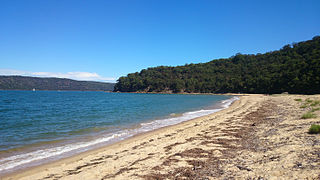
Blacksmiths is a coastal suburb of the City of Lake Macquarie in New South Wales, Australia adjacent to the Pacific Ocean 24 kilometres (15 mi) south of Newcastle's central business district, between the suburbs of Belmont and Swansea
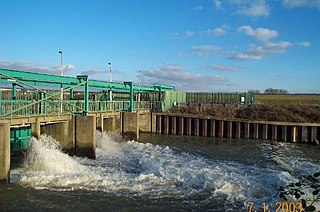
The Lee Flood Relief Channel (FRC) is located in the Lea Valley and flows between Ware, Hertfordshire, and Stratford, east London. Work started on the channel in 1947 following major flooding and it was fully operational by 1976. The channel incorporates existing watercourses, lakes, and new channels. Water from the channel feeds the Lee Valley Reservoir Chain.
The Lake Macquarie anti-submarine boom was a submarine and small boat defence boom located at the entrance to Lake Macquarie, New South Wales, Australia during World War II.

The Fernleigh Track is a multi-use rail trail near Belmont in New South Wales. The track was constructed in the way of the former Belmont railway line. The project is a joint venture between Newcastle City Council and City of Lake Macquarie. The track extends from Adamstown to Belmont over an approximate distance of 15.5 km (10 mi). The former railway closed in December 1991. The first section between Adamstown and Burwood Road opened in 2003. Construction has continued in stages with the final section between Jewells and Belmont completed in March 2011.

Lytton Hill is a heritage-listed signal station via South Street, Lytton, City of Brisbane, Queensland, Australia. It was built from 1859 to c. 1945. It is also known as Lytton Redoubt, Reformatory, and Signal Hill. It was added to the Queensland Heritage Register on 25 August 2000.

False Cape Battery is a heritage-listed fortification at Yarrabah Road, East Trinity, Cairns Region, Queensland, Australia. It was built from 1942 to 1943 during World War II. It is also known as Leper Bay. It was added to the Queensland Heritage Register on 18 April 1997.
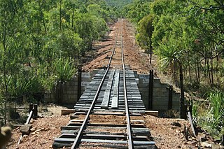
Etheridge railway line is a heritage-listed railway line between Mount Surprise and Forsayth, both in the Shire of Etheridge, Queensland, Australia. It includes Mount Surprise railway station, Einasleigh railway station, Wirra Wirra railway station and Forsayth railway station. Etheridge railway line was added to the Queensland Heritage Register on 16 February 2009.

Yooroonah Tank Barrier is a heritage-listed former tank barrier at Waterfall Way, Ebor, Armidale Regional Council, New South Wales, Australia. It was designed by Eastern Military Command and built in 1942 by the NSW Department of Main Roads, the Dumaresq Shire, local workers and miners. It is also known as Yooroonah Tank Traps and Ebor Tank Traps. The property is owned by the Office of Environment and Heritage, Roads and Maritime Services and the Rural Lands Protection Boards State Council. It was added to the New South Wales State Heritage Register on 27 November 2009.

Liverpool Weir is a heritage-listed weir on the Georges River at Heathcote Road near Newbridge Road, Liverpool, Sydney, New South Wales, Australia. It was designed by David Lennox and built from 1836 by convict labour, directed by Captain W. H. Christie. It is also known as Bourke's Dam. It was added to the New South Wales State Heritage Register on 13 August 2010.

