South Waratah Colliery

Last updated
South Waratah Colliery
Location
Australia location map.svg
Schlaegel und Eisen nach DIN 21800.svg
South Waratah Colliery
Location in Australia
Location Kotara South
State New South Wales
Country Australia
Coordinates 32°57′25″S151°41′39″E / 32.95694°S 151.69417°E / -32.95694; 151.69417
Production
ProductsCoal
History
Opened1873
Closed1961
Owner
CompanyWaratah Coal Company
South Waratah Coal Line
BSicon KDSTa.svg
Port Waratah
BSicon BST.svg
Morandoo Sidings
BSicon SBRUCKE.svg
Industrial Highway
BSicon SBRUCKE.svg
Maitland Road
BSicon CONTgq.svg
BSicon xKRZlr+xl.svg
BSicon CONTfq.svg
Main North Line (Islington Junction)
BSicon exDST.svg
Exchange Sidings
BSicon exBST.svg
Bulbeck's Siding
BSicon exBUE.svg
Georgetown Road
BSicon exBST.svg
Newcastle Lime & Cement Siding
BSicon exKRZ.svg
Old Lambton Railway Crossing
BSicon exBUE.svg
Young Road
BSicon exhKRZWae.svg
Styx Creek
BSicon exBUE.svg
Lambton Road
BSicon CONTgq.svg
BSicon xKRZu.svg
BSicon CONTfq.svg
BSicon exDST.svg
Stuart's Pit
BSicon exDST.svg
Crofton Colliery
BSicon exKDSTe.svg
South Waratah Colliery

The South Waratah Colliery (later just Waratah Colliery) was a coal mine located at Charlestown, in New South Wales Australia.

Contents

History

The Waratah Coal was formed in 1862 to work a tunnel colliery at Waratah, which was served by a privately owned railway line running to the Hunter River at a location that was to be known as Port Waratah. By 1873 the coal reserves at the tunnel mine at Waratah were becoming exhausted so the Waratah Coal Company purchased an area of land near what would be known as Charlestown. [1] Sinking of a shaft on this land soon commenced, with this shaft being initially known as the Raspberry Gully Pit and latter known as Charles' Pit. To serve this new colliery a colliery branch line, known as the Gully Line or Raspberry Gully Line was laid from the existing line to the Waratah tunnel mines near the crossing of the Scottish Australian Coal Mining Company's Lambton Colliery line, to the colliery. Construction of this new line commenced in January 1874 and an Act of Parliament was obtained to allow the construction of railway branch lines to the new shaft at Raspberry Gully and a new tunnel mine at Waratah. [1] [2]

By March 1874 the Raspberry Gully shaft had yet to strike the aimed for Borehole Seam of coal, so the directors of the Waratah Coal Company decided to sink a shaft closer to existing working collieries where the seam was known to exist and was being worked. This shaft was adjacent to the route of the railway line being constructed to the Raspberry Gully mine, and was known as Stuart's Pit. [1] Work on this colliery stopped soon after the Borehole seam was struck as the coal seam was only 0.431m thick.

With the failure of Stuart's Pit all the plant from this mine was relocated to the Raspberry Gully mine. By July 1876 the railway line had reached the boundary of the mine. The Borehole seam had finally been struck at the Raspberry Gully mine but had also been proven to be too thin, with the seam being only 0.838m thick at the shafts. During sinking a 3.2m thick seam of coal had been struck at a depth of 81.3m, a decision was made to work this seam which as known as the Gully Seam instead. [1]

A town grew from the influx of miners from the mine to the south and was named after Charles Smith, the manager of the Waratah Coal Company in the 1870s, and became known as Charlestown.

In 1886 the main shaft was sunk to the Borehole seam and another shaft was also sunk to the Borehole seam at Flaggy Creek which was located approximately 1 mile to the east. The Borehole seam at Flaggy Creek was 10 ft thick, however due to unsuitable ground conditions at the surface the Waratah Coal Company was unable to construct railway sidings & loading facilities at this site so a 2120 yard long tunnel was driven between the Flaggy Creek shaft & Charles' Pit. Soon after this Charles' Pit was officially opened with a special train being run to the colliery on 25 November 1887. [1]

During a strike at the mine in 1888, eight houses were built in Charlestown for strike breakers. The houses became known as Scab Row. During a confrontation with strike breakers, Alfred Edden, President of the Waratah Colliery Miners' Lodge was arrested. He later became Member of the Legislative Assembly (MLA) for the electoral district of Kahibah in 1894.

Due to the high cost of driving the tunnel between Charles' Pit & the Flaggy Creek shaft due to the coal being too thin to work for two thirds of its length caused the Waratah Coal Company to have financial difficulties and in October 1893 the Waratah Coal Company was placed into liquidation. A new company, The Waratah Coal Company Limited, was formed to take over the operations of the original Waratah company. However, by 1897 this new company was taken over by the Caledonian Coal Company Limited. [1]

In 1901 mining recommenced on the Victoria Tunnel seam which was located above the Borehole seam. Both the Borehole & Victoria Tunnel seams were then worked until 1906 when working of the Borehole seam ceased. The Borehole seam workings were abandoned in 1912 and the fan at the Flaggy Creek shaft was stopped as this shaft only served the Borehole seam workings. [1]

In 1952 a drift was sunk to the Wavehill seam in a hill to the west of the existing shafts. This drift was known as Waratah Colliery No.2 drift and was a mechanised mine using Mavour & Coulson coal cutters, Joy 14BU loaders & Joy battery operated shuttle cars. The shuttle cars loaded the coal onto a conveyor belt which transported the coal to a new set of screens & loading point close to the original screens. No.2 drift was closed on 19 May 1961 after working out all economic coal reserves. [1]

In 1956 a drift was sunk to the Victoria Tunnel seam to the north of the existing shafts. This drift was known as Waratah North Colliery (No.3 drift). Similar to No.2 drift this was a mechanised mine & was worked using similar equipment. The coal won from this drift was moved by a conveyor belt to a newly constructed screens & loading point. With the opening of Waratah North coal haulage from the shafts ceased & the shafts were then only used for ventilation & a second means of egress from the mine. Waratah North closed on 20 June 1960. [1]

In 1959 a 'Acco Jig' coal preparation plant was constructed to wash the coal produced at Waratah Colliery. The coal from Nos.2 & 3 drifts was loaded into railway coal wagons at their screens & then ran to a dump hopper at the preparation plant where the coal was emptied & ran through the preparation plant. The coal was then reloaded into wagons for transport. [1]

In 1959 a drift was sunk to South West of the existing shafts, this drift was known as Waratah Colliery No.4 Drift. This drift was driven to the Wave Hill seam above the existing Victoria Tunnel seam workings, and once it had passed the previously mined section of the Victoria Tunnel seam a drift was then sunk to the virgin area of the Victoria Tunnel seam. No.4 Drift was a mechanised mine similar to Nos.2 & 3 drifts & was worked using similar equipment. The coal was delivered directly by conveyor belt to the new coal preparation plant where it was loaded into wagons after washing.

The Colliery Today

The colliery was closed in 1961 and after standing idle and intact was finally demolished in 1969. [1] There are some remnants of the colliery such as Stuart's Pit, which is now filled with water, heavily vegetated and in the grounds of St Pius X High School, Adamstown.

Lake Macquarie City Council has created a short heritage trail depicting a brief history of the former Waratah Colliery and rail corridor which carried coal from the mine to Port Waratah, with interpretative signage located along a multi-use pathway.

Related Research Articles

Charlestown is a suburb of the City of Lake Macquarie, New South Wales, Australia, and the largest suburb in Lake Macquarie and in the Greater Newcastle area. It is approximately 10 kilometres (6 mi) west-south-west of the central business district of Newcastle.

<span class="mw-page-title-main">Caphouse Colliery</span>

Caphouse Colliery, originally known as Overton Colliery, was a coal mine in Overton, near Wakefield, West Yorkshire, England. It was situated on the Denby Grange estate owned by the Lister Kaye family, and was worked from the 18th century until 1985. It reopened as the Yorkshire Mining Museum in 1988, and is now the National Coal Mining Museum for England.

<span class="mw-page-title-main">Tower Colliery</span> Historic Welsh coal mine active until 2008

Tower Colliery was the oldest continuously working deep-coal mine in the United Kingdom, and possibly the world, until its closure in 2008. It was the last mine of its kind to remain in the South Wales Valleys. It was located near the villages of Hirwaun and Rhigos, north of the town of Aberdare in the Cynon Valley of South Wales.

<span class="mw-page-title-main">Kent Coalfield</span> Coal mining area in England

The Kent Coalfield is a coalfield in the eastern part of the English county of Kent. The Coalfields Trust defines the Kent Coalfield as the wards of Barham Downs and Marshside in the Canterbury district, and the wards of Aylesham, Eastry, Eythorne & Shepherdswell, Middle Deal & Sholden, Mill Hill and North Deal in the Dover district.

Agecroft Colliery was a coal mine on the Manchester Coalfield that opened in 1844 in the Agecroft district of Pendlebury, Lancashire, England. It exploited the coal seams of the Middle Coal Measures of the Lancashire Coalfield. The colliery had two spells of use; the first between 1844 and 1932, when the most accessible coal seams were exploited, and a second lease of life after extensive development in the late 1950s to access the deepest seams.

<span class="mw-page-title-main">Wet Earth Colliery</span> Historical industrial site in England

Wet Earth Colliery was a coal mine located on the Manchester Coalfield, in Clifton, Greater Manchester. The colliery site is now the location of Clifton Country Park. The colliery has a unique place in British coal mining history; apart from being one of the earliest pits in the country, it is the place where engineer James Brindley made water run uphill.

Baggeridge Colliery was a colliery located in Sedgley, West Midlands England.

<span class="mw-page-title-main">Pleasley Colliery</span>

Pleasley Colliery is a former English coal mine. It is located to the north-west of Pleasley village, which sits above the north bank of the River Meden on the Nottinghamshire/Derbyshire border. It lies 3 miles (4.8 km) north of Mansfield and 9 miles (14.5 km) south of Chesterfield. From the south it commands a prominent position on the skyline, although less so now than when the winders were in operation and both chimney stacks were in place. The colliery is situated at about 500 ft (152m) above sea level and is aligned on a NE–SW axis following the trend of the river valley at this point.

<span class="mw-page-title-main">Chatterley Whitfield</span> Disused coal mine in Chell, Staffordshire, England

Chatterley Whitfield Colliery is a disused coal mine on the outskirts of Chell, Staffordshire in Stoke on Trent, England. It was the largest mine working the North Staffordshire Coalfield and was the first colliery in the UK to produce one million tons of saleable coal in a year.

Cynheidre Colliery was a coal mine located in the Gwendraeth valley, in Carmarthenshire, South Wales. Opened in 1954, it closed in 1989.

<span class="mw-page-title-main">Ingleton Coalfield</span> Coalfield in North Yorkshire, England

The Ingleton Coalfield is in North Yorkshire, close to its border with Lancashire in north-west England. Isolated from other coal-producing areas, it is one of the smallest coalfields in Great Britain.

Fletcher, Burrows and Company was a coal mining company that owned collieries and cotton mills in Atherton, Greater Manchester, England. Gibfield, Howe Bridge and Chanters collieries exploited the coal mines (seams) of the middle coal measures in the Manchester Coalfield. The Fletchers built company housing at Hindsford and a model village at Howe Bridge which included pithead baths and a social club for its workers. The company became part of Manchester Collieries in 1929. The collieries were nationalised in 1947 becoming part of the National Coal Board.

<span class="mw-page-title-main">Bickershaw Colliery</span> Former coal mine in Lancashire, England

Bickershaw Colliery was a coal mine, located on Plank Lane in Leigh, then within the historic county boundaries of Lancashire, England.

The Tarenni Colliery and its associated workings, are a series of coal mines and pits located between the villages of Godre'r Graig and Cilybebyll located in the valley of the River Tawe, in Neath Port Talbot county borough, South Wales.

<span class="mw-page-title-main">Wheldale Colliery</span> Former coal mine in Castleford, West Yorkshire, England

Wheldale Colliery was a coal mine located in Castleford, Yorkshire, England which produced coal for 117 years. It was accessed from Wheldon Road.

<span class="mw-page-title-main">Burnley Coalfield</span> Coal mining region in England

The Burnley Coalfield is the most northerly portion of the Lancashire Coalfield. Surrounding Burnley, Nelson, Blackburn and Accrington, it is separated from the larger southern part by an area of Millstone Grit that forms the Rossendale anticline. Occupying a syncline, it stretches from Blackburn past Colne to the Yorkshire border where its eastern flank is the Pennine anticline.

Hapton Valley Colliery was a coal mine on the edge of Hapton near Burnley in Lancashire, England. Its first shafts were sunk in the early 1850s and it had a life of almost 130 years, surviving to be the last deep mine operating on the Burnley Coalfield.

<span class="mw-page-title-main">Richmond Main Colliery</span> Historic site in New South Wales, Australia

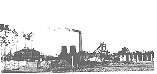
Richmond Main Colliery is a heritage-listed former coal mine and now open-air museum at South Maitland Coalfields, Kurri Kurri, New South Wales, Australia. It was designed by the staff at J & A Brown's Engineering Workshops at Hexham under the direction of John Brown and built from 1908 to 1913 by J & A Brown. The site now operates as the Richmond Main Heritage Park, including the Richmond Vale Railway Museum and Richmond Main Mining Museum. The property is owned by Cessnock City Council. It was added to the New South Wales State Heritage Register on 2 April 1999.

Western Jharia Area is one of the 12 operational areas of BCCL located in Dhanbad Sadar subdivision of Dhanbad district in the state of Jharkhand, India.

References

  1. 1 2 3 4 5 6 7 8 9 10 11 Andrews, Brian Robert (2009). Coal, Railways and Mines: The Collieries of the Newcastle District Vol.1. Iron Horse Press. ISBN   978-0-9805106-8-3.
  2. Waratah Coal Company Act of 1875