No. 208 Radar Station RAAF

Last updated

No. 208 Radar Station RAAF
1752 - WWII RAAF Radar Station 208 (former) - SHR Plan 2068 (5054690b100).jpg
Heritage boundaries
Location Catherine Hill Bay, City of Lake Macquarie, New South Wales, Australia
Coordinates 33°08′01″S151°38′09″E / 33.1336°S 151.6358°E / -33.1336; 151.6358 Coordinates: 33°08′01″S151°38′09″E / 33.1336°S 151.6358°E / -33.1336; 151.6358
Built19421943
Official nameWWII RAAF Radar Station 208 (former); Mine Camp; Signal Hill; Radar Hill
Typestate heritage (built)
Designated22 July 2008
Reference no.1752
TypeDefence Radar Station
CategoryDefence
BuildersAllied Works Council
Australia New South Wales relief location map.png
Red pog.svg
Location of No. 208 Radar Station RAAF in New South Wales

No. 208 Radar Station RAAF is a heritage-listed former Royal Australian Air Force (RAAF) radar station at Mine Camp at Catherine Hill Bay and Pinny Beach, both in City of Lake Macquarie, New South Wales, Australia. It was established on 10 February 1943. The remains of the radar station were added to the New South Wales State Heritage Register on 22 July 2008. [1]

Contents

History

The radar station was built by the Allied Works Council to monitor enemy airborne threats during World War II. It was one of nine Advanced Chain Overseas (ACO) radar installations on mainland Australia. The War Cabinet had originally intended to have 32 units to implement the plan for Australia's radar station chain, but this became difficult to achieve and later unnecessary after significant events that changed the course of the war. The ACO radar equipment sent to Australia was originally intended for other territories such as Malaya and Singapore but diverted after Japanese invasion of these countries. [1]

Radar Station 208 was sited on a ridge 93m above sea level amongst dense woodland overlooking the ocean. The transmitter and receiver towers were over 44 metres in height and spaced 100metres apart to ensure that radio pulses were received as echoes and not confused with transmissions. The floodlight system of the ACO radars required a high volume of electrical power sourced from power mains with backup generator located in a smaller dedicated bunker. Bombproof bunkers, meant to be underground, housed the electronics for transmitter and receiver, each console weighing two tonnes. [1]

According to RAAF records, "No. 208 RDF Station formed to establishment No. HD 318 of Mine Camp, NSW on 10th February 1943 under the control of H.Q. Eastern Area. The purpose of the unit is, by means of Radio Direction Finding to locate and promulgate advice of enemy and other aircraft approaching to locality of the station". [1]

At its establishment it had a total of 41 personnel consisting of 1 RAAF Officer, 1 WAAAF Officer, 14 RAAF and 25 WAAAF, the personnel levels peaked in May 1943 with a total of 54. The radar Operators were from the Women's Auxiliary Australian Air Force (WAAAF). The radar mechanics were from the Royal Australian Air Force. The unit also included guards, cooks and other trades. The Operators communicated plotted data to the Fighter Unit in Newcastle by land line or radio telephone. [1]

The radar operator monitored aircraft activity from an eleven-inch cathode ray tube screen. Using the goniometer consisting of switches and controls of the direction and height finding components, the operator would alter the screen and make comparisons to decipher the direction, elevation and distance of the aircraft. The radar mechanics were required to regularly climb the radar towers to service relay switches and aerials. [1]

The ACO, a fixed radar station, had some advantages over others with its quick height finding capabilities and ability to monitor aircraft movements up to 200 miles. The radar station also served RAAF Base Rathmines, monitoring movements of Catalinas and other aircraft. Plotted data was communicated to the command centre, Fighter Station No 2 located 26 km north of the installation. [1]

In August 1944 No. 208 Radar Station RAAF ceased to be a 24-hour operation and personnel numbers were steadily reduced until 28 January 1947 when it was disbanded. [1]

Associated sites - Mine Camp

RAAF and WAAAF personnel of Radar Station 208 were stationed at a small township near Catherine Hill Bay below the radar station, which once served as a camp during the early mining period. The first shipment of coal from the area was made in 1873 by the New Wallsend Coal Company. Initially a shanty town served the miners but by the 1870s a miners settlement was established boasting 20 houses. [2] The arrival of forty five WAAAF and RAAF personnel doubled the townships population which had one shop and a post office. Additional living quarters were erected for personnel that imitated the existing housing within the township for camouflage purposes. [1]

Some civilians remained at Mine Camp village and, soon after the war, the Housing Commission of New South Wales acquired the RAAF property, yet numbers declined and the post office closed in 1952. In 1969 twelve dwellings remained. In 1969 twelve dwellings remained and soon after the Housing Commission of New South Wales acquired the property. In the 1980s the village was destroyed by bush fire. [1]

Commanding officers

Description

The former Radar Station 208 site has a north and south arrangement with principal structures replicated in each sector. There are two arrangements of four concrete footings that originally supported 44 metre timber aerial towers. The footings are arranged in a square pattern with remnant steel supports protruding from each block. Two concrete above ground igloo shaped bunkers remain, each with a square turret on the seaward side. The footings and bunkers are symmetrically placed across an east–west axis. The bunkers have remnants of electrical fittings and recessed areas on the internal walls and concrete slab floors and an egress on the eastern walls. The southern area has a remnant rectangular shaped concrete support for the tower ladder rising several centimetres above the ground surface. The northern area has a remnant concrete stair structure of approximately half a metre high with three steps and the outer rim concrete remains of a depressed circular structure. [1]

A two-metre safety fence, erected in the 1990s, is located on the northern and eastern boundary and isolates the footings and other above surface remains in the northern section. The eastern side of the northern bunker is one and a half metres from the cliff edge. [1]

The southern sector arrangement of footings was reported to be well preserved and obscured by dense regrowth vegetation as at 7 February 2006. The northern sector footings were reported to show a greater level of deterioration with exposure to coastal conditions. [1]

The concrete bunkers have been subject to graffiti and fire but remain in good condition. There is some evidence of concrete cancer to the buildings in the form of exposed reinforcing where minor concrete spalling has occurred. [1]

Heritage listing

The former RAAF Radar Station 208 at Catherine Hill Bay, comprising remains of the RAAF radar installation is significant as a rare example of NSW's participation in the WWII network of air warning radar, established in strategic locations along Australia's coast during World War II. It is one of nine ACO radar stations established on mainland Australia using British imported ACO radar and the only remaining site of the two established in NSW. [1]

Its location and siting on an elevated coastal area amongst dense bushland demonstrates Australia's response to the threat of invasion and the importance placed on protecting the industrial centres along NSW coastline during WWII. [1]

The site has potential to yield further information about Australian coastal defence efforts during WWII and the use and development of radar technology. [1]

It has historical associations with the introduction, use and development of radar technology in Australia which is regarded as one of the greatest contributions of Australian science to the war effort. The wartime development of radar in Australia became a key element in the shift towards government sponsored applied scientific research [3] and the gradual independence of Australian science. After the war, radar became a celebrated achievement of science in Australia. [3] [1]

WWII RAAF Radar Station 208 was listed on the New South Wales State Heritage Register on 22 July 2008 having satisfied the following criteria. [1]

The place is important in demonstrating the course, or pattern, of cultural or natural history in New South Wales.

The remains of the former Radar Station 208 illustrates Australia's response to the imminent threat of invasion during WWII and the role of NSW in the defence of Australia. Its setting demonstrates the importance of NSW's industrial region and military efforts for its protection during the war. [1]

It represents a distinct stage of the introduction of radar technology that led to innovative adaptation and advancement of radar technology by Australian scientists and engineers in NSW during WWII. [1]

The place has a strong or special association with a person, or group of persons, of importance of cultural or natural history of New South Wales's history.

The former Radar Station 208 is of State significance for its association with the RAAF which were given responsibility for the nation's air warning defence operations during WWII and exservice RAAF and WAAAF personnel that served during WWII. It has strong associations with the role of women WAAAF who served as radar operators during WWII. [1]

The place is important in demonstrating aesthetic characteristics and/or a high degree of creative or technical achievement in New South Wales.

The technical integrity and aesthetic characteristics have been lost with the removal of associated electrical and timber fabric of the aerial towers. The siting of the above ground bunkers demonstrate an Australian adaptation. [1]

The place has strong or special association with a particular community or cultural group in New South Wales for social, cultural or spiritual reasons.

The former Radar Station 208 is of State significance for its association with veteran groups and RAAF and WAAAF personnel that served during WWII. [1]

The place has potential to yield information that will contribute to an understanding of the cultural or natural history of New South Wales.

It has potential to yield further information about NSW during WWII and its role in the network of the nation's air warning defence during this period. It is a reminder of NSW's role in the introduction and development of radar technology during the war. [1]

The place possesses uncommon, rare or endangered aspects of the cultural or natural history of New South Wales.

The former Radar Station 208 is the only intact example of a WWII ACO radar station in NSW. It was one of nine installations established in Australia during the war, and the only one remaining of the two located in NSW. The use and development of radar is an uncommon aspect of NSW's WWII history. [1]

The place is important in demonstrating the principal characteristics of a class of cultural or natural places/environments in New South Wales.

The former Radar Station 208 retains fabric of the original layout that demonstrates the characteristics of a WWII RAAF radar installation. [1]

Related Research Articles

<span class="mw-page-title-main">St James railway station, Sydney</span> Heritage-listed railway station in Sydney, New South Wales,Australia

St James railway station is a heritage-listed underground commuter rail station that is located on the City Circle, at the northern end of Hyde Park in the Sydney central business district of New South Wales, Australia. It is served by Sydney Trains T2 Inner West & Leppington, T3 Bankstown & T8 Airport & South line services. It is named after the nearby St James' Church and provides a direct link to the Sydney Airport international and domestic railway stations. It was added to the New South Wales State Heritage Register on 2 April 1999.

Air traffic control in Australia is provided by two independent organisations, one civilian and one military. The civilian provider is Airservices Australia, which controls civilian airfields and airspace. The military provider is the Royal Australian Air Force (RAAF), which controls military airfields and adjoining airspace. This includes Australian Army and Royal Australian Navy aviation bases. Some airfields in Australia are categorised as Joint User airfields, where there are both civilian and military operations based at the airfield. Normally, Joint User airfields have air traffic control provided by the RAAF.

<span class="mw-page-title-main">RAAF Base Rathmines</span> Former RAAF WWII seaplane base

RAAF Base Rathmines is a heritage-listed former RAAF Second World War seaplane base and now used as community venues, sports venues and a visitor attraction at Dorrington Road, Rathmines, City of Lake Macquarie, New South Wales, Australia. It was in use as an RAAF base from 1939 to 1961. It is also known as Rathmines Park, former RAAF Seaplane Base, Flying Boat Base, Rathmines Aerodrome and Catalina Base. The property is owned by Australian Christadelphian Bible School, Disability Life Enrichment, Don Geddes Nursing Home and Lake Macquarie City Council. The remains of the former air base was added to the New South Wales State Heritage Register on 25 November 2005.

<span class="mw-page-title-main">Evans Head Memorial Aerodrome</span> Airport in Australia

Evans Head Memorial Aerodrome is a heritage-listed airport in Evans Head, Richmond Valley Council, New South Wales. The airport is approximately 1 km (0.62 mi) north of the village. During World War II it was Royal Australian Air Force (RAAF) Station Evans Head supporting RAAF No 1 Bombing and Gunnery School (1BAGS) and subsequently the RAAF No 1 Air Observers School. At the height of operations there were three asphalt runways and one grass strip. Only a single asphalt strip is still in use by private aviation. It was added to the New South Wales State Heritage Register on 22 November 2002.

<span class="mw-page-title-main">Bankstown Bunker</span> Historic site in New South Wales, Australia

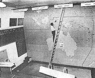
Bankstown Bunker, formerly known as Air Defence Headquarters Sydney, is a heritage-listed defunct Royal Australian Air Force (RAAF) operations facility, located on the corner of Marion and Edgar Street, in Condell Park, City of Canterbury-Bankstown, New South Wales, Australia. It was designed by Allied Works Council and built from 1943 to 1944 by Stuart Bros Pty Ltd of Sydney. It is also known as Air Defence Headquarters Ruin Sydney (former), No. 1 Fighter Section Headquarters, 1FSHQ, Bankstown Bunker and RAAF No. 1 Installation Bankstown; No. 101 Fighter Sector. It was added to the New South Wales State Heritage Register on 18 November 2011.

<span class="mw-page-title-main">No. 131 Radar Station RAAF</span> Historic site in New South Wales, Australia

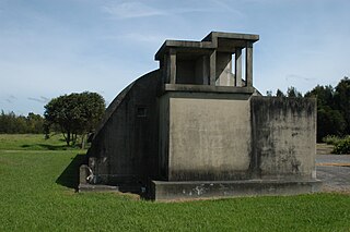
No. 131 Radar Station RAAF is a heritage-listed former Royal Australian Air Force radar station at Kooragang, City of Newcastle, New South Wales, Australia. They are also known as the Radar Igloo and Radar Buildings. They now operate as the Estuarine Interpretive Centre.

RAAF Bradfield Park was a Royal Australian Air Force (RAAF) station located at the former suburb of Bradfield Park, New South Wales during World War II.

<span class="mw-page-title-main">Breddan Aerodrome</span> Historic site in Queensland, Australia

Breddan Aerodrome is a heritage-listed abandoned aerodrome at Gregory Developmental Road, Breddan, Charters Towers Region, Queensland, Australia. It is located 15 kilometres (9.3 mi) north of Charters Towers. It was built from 1942 to 1943 by Allied Works Council and Queensland Main Roads Commission. The airfield was constructed for the USAAF 38th Bomb Group in August 1942 as a satellite field for Charters Towers Airport, and later used by the Royal Australian Air Force (RAAF) during World War II as a maintenance base. Consisting of two runways, the airfield was abandoned after 1948. Today, the remains of the airfield consist of some deteriorating runways, taxiways and hardstands, mostly being reclaimed by grassland and shrub. No buildings have survived. It is also known as Breddan Airfield and Breddan WWII Aircraft Maintenance, Repair and Salvage Depot. It was added to the Queensland Heritage Register on 16 April 2010.

No. 19 Radar Station RAAF was a Royal Australian Air Force radar station formed at Bombi near Bouddi, New South Wales, Australia on 15 April 1942.

No. 17 Radar Station RAAF was a Royal Australian Air Force radar station formed at Burrewarra Point, Guerilla Bay, New South Wales, Australia on 12 April 1943. The radar became operational on 29 April 1943 after initial training and setting up the radar equipment.

No. 18 Radar Station RAAF was a Royal Australian Air Force (RAAF) radar station formed at Richmond, New South Wales, Australia on 1 April 1942.

No. 20 Radar Station RAAF was a Royal Australian Air Force radar station formed at Nelson Bay, New South Wales, Australia, during World War II on 12 April 1942. The radar station was set up upon Tomaree Head, Port Stephens and became operational on 1 June 1942.

<span class="mw-page-title-main">Clare Stevenson</span> Australian military officer (1903–1988)

Clare Grant Stevenson, AM, MBE was the inaugural Director of the Women's Auxiliary Australian Air Force (WAAAF), from May 1941 to March 1946. As such, she was described in 2001 as "the most significant woman in the history of the Air Force". Formed as a branch of the Royal Australian Air Force (RAAF) in March 1941, the WAAAF was the first and largest uniformed women's service in Australia during World War II, numbering more than 18,000 members by late 1944 and making up over thirty per cent of RAAF ground staff.

<span class="mw-page-title-main">No. 227 Radar Station RAAF</span> Military unit

No. 227 Radar Station RAAF was a Royal Australian Air Force radar station located at Yanchep, Western Australia. Established during World War II to provide early warning of Japanese air raids against Perth, the radar station was formed in 1942–43 and operational by late 1943.

<span class="mw-page-title-main">Radar Station, Charlie's Hill</span> Radar station in Australia

Charlie's Hill Radar Station is a heritage-listed radar station off Charlie's Hill Road, Inkerman, Shire of Burdekin, Queensland, Australia. It was built in 1943 by Royal Australian Air Force. It was added to the Queensland Heritage Register on 23 February 2001.

<span class="mw-page-title-main">Operations and Signals Bunker, Wulguru</span> Historic site in Queensland, Australia

Operations and Signals Bunker is a heritage-listed signal station off Stuart Drive, Wulguru, City of Townsville, Queensland, Australia. It was built from 1942 to 1944. It is also known as James Cook University, RAAF No.3 Fighter Sector Headquarters (3FSHQ), and Stuart Immigration Hostel. It was added to the Queensland Heritage Register on 28 August 1998.

<span class="mw-page-title-main">Bones Knob Radar Station</span> Historic site in Queensland, Australia

Bones Knob Radar Station is a heritage-listed radar station at Bowcock Road, Tolga, Tablelands Region, Queensland, Australia. It was built in 1943. It is also known as WWII RAAF 220 Radar Station. It was added to the Queensland Heritage Register on 14 May 2010.

<span class="mw-page-title-main">Radar Hill, Mount Surprise</span> Heritage-listed radar station in Queensland, Australia

Radar Hill is a heritage-listed radar station at Gulf Developmental Road, Mount Surprise, Shire of Etheridge, Queensland, Australia. It was built about August 1943 by the Allied Works Council. It is also known as No. 53 RDF Station. It was added to the Queensland Heritage Register on 12 July 2005.

The Tomaree Head Fortifications is a heritage-listed fortification at 2 Shoal Bay Road, Shoal Bay, New South Wales, Australia. It is also known as Tomaree Head Battery, Tomaree Battery and Stephens Battery. It was added to the New South Wales State Heritage Register on 22 October 2010.

<span class="mw-page-title-main">World War II Aeroplane Hangar, Tocumwal</span> Historic site in Berrigan Shire. New South Wales, Australia

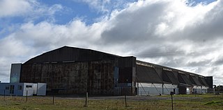
World War II Aeroplane Hangar, Tocumwal is a heritage-listed former Royal Australian Air Force (RAAF) aircraft hangar at Tocumwal, in Berrigan Shire, New South Wales, Australia. The hangar was constructed in 1942 by the Allied Works Council as part of the construction of RAAF Station Tocumwal. The hangar was added to the New South Wales State Heritage Register on 25 July 2021.

References

  1. 1 2 3 4 5 6 7 8 9 10 11 12 13 14 15 16 17 18 19 20 21 22 23 24 25 26 27 "WWII RAAF Radar Station 208 (former)". New South Wales State Heritage Register . Department of Planning and Environment. H01752. Retrieved 2 June 2018. CC-BY icon.svg Text is licensed by State of New South Wales (Department of Planning and Environment) under CC-BY 4.0 licence .
  2. Newcastle Herald 1987
  3. 1 2 MacLeod 1999

Bibliography

Attribution

CC BY icon-80x15.png This Wikipedia article contains material from WWII RAAF Radar Station 208 (former) , entry number 01752 in the New South Wales State Heritage Register published by the State of New South Wales (Department of Planning and Environment) 2018 under CC-BY 4.0 licence , accessed on 2 June 2018.