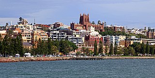
Greater Newcastle is a regional metropolitan area and the second-most-populated district in New South Wales, Australia. It includes the cities of Newcastle and Lake Macquarie; it is the hub of the Lower Hunter region, which includes most parts of the local government areas of City of Newcastle, City of Lake Macquarie, City of Maitland, City of Cessnock and Port Stephens Council.
Francis Howard Greenway was an English-born architect who was transported to Australia as a convict for the crime of forgery. In New South Wales he worked for the Governor, Lachlan Macquarie, as Australia's first government architect. He became widely known and admired for his work displayed in buildings such as St Matthew's Church, St James' Church and Hyde Park Barracks.
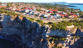
Vaucluse is an eastern suburb of Sydney, in the state of New South Wales, Australia. It is located 8 kilometres (5 mi) east of the Sydney central business district, in the local government areas of Waverley Council and the Municipality of Woollahra.

Woollahra Municipal Council is a local government area in the eastern suburbs of Sydney, in the state of New South Wales, Australia. Woollahra is bounded by Sydney Harbour in the north, Waverley Council in the east, Randwick City in the south and the City of Sydney in the west.

The Sydney Heads are a series of headlands that form the 2 km (1.2 mi) wide entrance to Sydney Harbour in Sydney, New South Wales, Australia. North Head and Quarantine Head are to the north; South Head and Dunbar Head are to the south; and Middle Head, Georges Head, and Chowder Head are to the west and within the harbour. The Heads are contained within the Sydney Harbour National Park.

Hornby Lighthouse, also known as South Head Lower Light or South Head Signal Station, is a heritage-listed active lighthouse located on the tip of South Head, New South Wales, Australia, a headland to the north of the suburb Watsons Bay. It marks the southern entrance to Port Jackson, as well as lighting the South Reef, a ledge of submerged rocks. It is the third oldest lighthouse in New South Wales. Designed by Mortimer Lewis and listed on the Register of the National Estate and on the New South Wales State Heritage Register since 2 April 1999, with the following statement of significance:
A dominant Sydney landmark which appears to have been in continuous use since the 1840s as a controlling point for shipping entering and leaving Port Jackson. The building complex, designed by the Colonial Architect Mortimer Lewis in the early 1840s, is an architectural important example of an early Victorian public work associated with port activities.

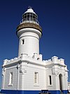
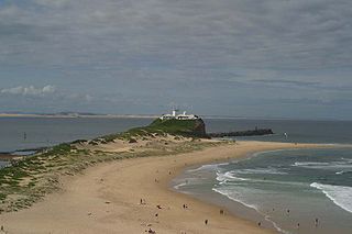
Norah Head, originally known as Bungaree Noragh Point, is a headland and a coastal village in the Central Coast Council local government area on the Central Coast of New South Wales, Australia. Norah Head is known for its great surfing and clear beaches like Soldiers Beach near Wyrrabalong National Park and Pebbly Beach with Norah Head Rock Pool. The town is home to Norah Head Lighthouse with scenic views along the coast.

The City of Lithgow is a local government area in the Central West region of New South Wales, Australia. The area is located adjacent to the Great Western Highway and the Main Western railway line.

Wollongong Breakwater Lighthouse, also known as Wollongong Harbour Lighthouse, is a historic lighthouse situated on the southern breakwater of the heritage-listed Wollongong Harbour, in Wollongong, New South Wales in Australia. Wollongong is the only place in the east of Australia to have two lighthouses located in close proximity of each other, the other being Wollongong Head Lighthouse. While no longer used, the lighthouse was restored in 2002 as operational and is listed an official local heritage building.

The Hill is an inner city, residential suburb of Newcastle, in the Hunter Region of New South Wales, Australia, located immediately south of Newcastle's central business district. The Hill is filled with historic Victorian terraces and is the site of a historic convict prison block. As of January 2021, the average house price in The Hill was A$1.92m.
Newcastle East is an inner city suburb of Newcastle, New South Wales, Australia, located immediately east of Newcastle's central business district at the mouth of the Hunter River. The Awabakal and Worimi peoples are acknowledged by City of Newcastle as the descendants of the traditional custodians of the land situated within the Newcastle local government area, including wetlands, rivers creeks and coastal environments. It is known that their heritage and cultural ties to Newcastle date back tens of thousands of years. The suburb includes Fort Scratchley, Newcastle Ocean Baths and Newcastle Beach. Formerly a site of heavy industry and railway yards, the suburb now contains the large Foreshore Park, and historic terraced housing.
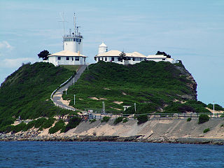
Nobbys Head is a headland located on the southern entrance to Newcastle Harbour, New South Wales, Australia. The headland is situated above the Hunter River and the Tasman Sea of the South Pacific Ocean.

Colonel Walter Liberty Vernon was an English architect who migrated to Australia and pursued his career as an architect in Sydney, New South Wales. In his role as the New South Wales Government Architect he is noted for designing multiple government buildings, many of which are extant with listings on national and state heritage registers.

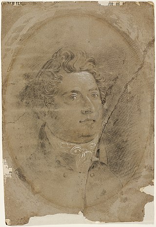
Mortimer William Lewis was an English-born architect, surveyor and public servant who migrated to Australia and became Colonial Architect in the colony of New South Wales from 1835 to 1849. Lewis was responsible for designing and overseeing many government buildings in Sydney and rural New South Wales, many of which are heritage listed.

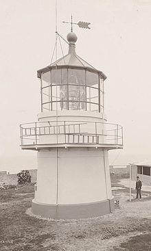
The Bradleys Head Light is an active heritage-listed lighthouse at Bradleys Head, a headland protruding from the north shore of Sydney Harbour, within Mosman, Mosman Council, Sydney, New South Wales, Australia. It is the sibling of Robertson Point Light. The site is owned and managed as part of the Sydney Harbour National Park by the NSW National Parks and Wildlife Service, an agency of the Government of New South Wales; while the light is managed and operated by Sydney Ports Corporation. It was added to the New South Wales State Heritage Register on 18 April 2000.


The Wollongong Head Lighthouse, also known as Flagstaff Hill Lighthouse or Flagstaff Point Light, is an active lighthouse located adjacent to the heritage-listed Wollongong Harbour precinct in Wollongong, a coastal city south of Sydney, New South Wales, Australia. It overlooks the Tasman Sea from the top of Flagstaff Point, directly east of the city centre. Wollongong is the only place in the east of Australia to have two lighthouses located in close proximity of each other, the other being Wollongong Breakwater Lighthouse.
Coal River Precinct is a heritage-listed historic precinct at Nobbys Road, Newcastle, New South Wales, Australia. It was built from 1804 to 1960. It includes Fort Scratchley, Nobbys Head, the Convict Lumber Yard site, Macquarie Pier, the breakwater and Nobby's Beach. It was added to the New South Wales State Heritage Register on 19 December 2003.