Related Research Articles
The Wiradjuri people are a group of Aboriginal Australian people from central New South Wales, united by common descent through kinship and shared traditions. They survived as skilled hunter-fisher-gatherers, in family groups or clans, and many still use knowledge of hunting and gathering techniques as part of their customary life.

Petrified wood, also known as petrified tree, is the name given to a special type of fossilized wood, the fossilized remains of terrestrial vegetation. Petrifaction is the result of a tree or tree-like plants having been replaced by stone via a mineralization process that often includes permineralization and replacement. The organic materials making up cell walls have been replicated with minerals. In some instances, the original structure of the stem tissue may be partially retained. Unlike other plant fossils, which are typically impressions or compressions, petrified wood is a three-dimensional representation of the original organic material.
The Florissant Formation is a sedimentary geologic formation outcropping around Florissant, Teller County, Colorado. The formation is noted for the abundant and exceptionally preserved insect and plant fossils that are found in the mudstones and shales. Based on argon radiometric dating, the formation is Eocene in age and has been interpreted as a lake environment. The fossils have been preserved because of the interaction of the volcanic ash from the nearby Thirtynine Mile volcanic field with diatoms in the lake, causing a diatom bloom. As the diatoms fell to the bottom of the lake, any plants or animals that had recently died were preserved by the diatom falls. Fine layers of clays and muds interspersed with layers of ash form "paper shales" holding beautifully-preserved fossils. The Florissant Fossil Beds National Monument is a national monument established to preserve and study the geology and history of the area.
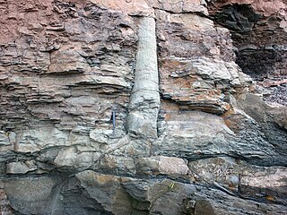
A polystrate fossil is a fossil of a single organism that extends through more than one geological stratum. The word polystrate is not a standard geological term. This term is typically found in creationist publications.
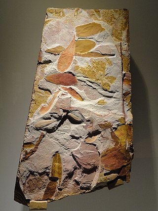
Glossopteris is the largest and best-known genus of the extinct Permian order of seed plants known as Glossopteridales. The genus Glossopteris refers only to leaves, within a framework of form genera used in paleobotany. Species of Glossopteris were the dominant trees of the middle to high-latitude lowland vegetation across the supercontinent Gondwana during the Permian Period. Glossopteris fossils were critical in recognizing former connections between the various fragments of Gondwana: South America, Africa, India, Australia, New Zealand, and Antarctica.

Belmont is a suburb in the City of Lake Macquarie New South Wales, Australia, located 20 kilometres (12 mi) from Newcastle's central business district on the eastern side of Lake Macquarie.
Awabakallanguage is an Australian Aboriginal language that was spoken around Lake Macquarie and Newcastle in New South Wales. The name is derived from Awaba, which was the native name of the lake. It was spoken by Awabakal and Wonnarua peoples.

The Awabakal people, are those Aboriginal Australians who identify with or are descended from the Awabakal tribe and its clans, Indigenous to the coastal area of what is now known as the Hunter Region of New South Wales. Their traditional territory spread from Wollombi in the west, to the Lower Hunter River near Newcastle and Lake Macquarie in the north.
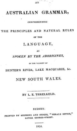
An Australian grammar : comprehending the principles and natural rules of the language, as spoken by the Aborigines in the vicinity of Hunter's River, Lake Macquarie, &c. New South Wales is a book written by Lancelot Edward Threlkeld and published in Sydney in 1834. It is a grammar of the Awabakal language.
Kuringgai is an ethnonym referring to an Indigenous Australian people occupying the territory between the southern borders of the Gamilaraay and the area around Sydney, and an historical people with its own distinctive language, located in part of that territory.
Lancelot Edward Threlkeld was an English missionary, primarily based in Australia. He was married twice and survived by sons and daughters from both marriages. Threlkeld is known for his work with Biraban in recording and publishing English translations of the Awabakal language.

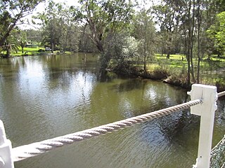
Lake Macquarie is Australia's largest coastal lagoon. Located in the City of Lake Macquarie and Central Coast Council local government areas in the Hunter and Central Coast regions of New South Wales, Australia, it covers an area of 110 square kilometres (42.5 sq mi) and is connected to the Tasman Sea by a short channel. Most of the residents of the City of Lake Macquarie live near the shores of the lagoon.
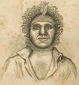
Biraban was a leader of the Awabakal people, an Aboriginal Australian people who lived in the area around what is today Lake Macquarie. His native name prior to Awabakal initiation was We-pohng; his naming as Biraban is reference to his totemic relationship with the eaglehawk.
Dora creek is a watercourse that is located in Greater Newcastle in the Hunter region of New South Wales, Australia.
Fennell Bay is a lakeside suburb of the City of Lake Macquarie, Greater Newcastle in New South Wales, Australia north of the town of Toronto on a bay of the same name, on the north western shore of Lake Macquarie.
Ebenezer Colliery was a coal mine located at Coal Point, New South Wales, Australia.
Henri was a 364 burthen ton brig that was wrecked upon Reids Mistake, near the entrance to Lake Macquarie, New South Wales, Australia.
Reverend Dr John Fraser was an Australian ethnologist, linguist, school headmaster and author of many scholarly works. He is known for his revised and expanded version of Lancelot Threlkeld's 1834 work, An Australian Grammar, with the new title An Australian language as spoken by the Awabakal, the people of Awaba or Lake Macquarie being an account of their language, traditions and customs / by L.E. Threlkeld; re-arranged, condensed and edited with an appendix by John Fraser (1892). In this, Fraser created new divisions and terminology for some Aboriginal groups in New South Wales.

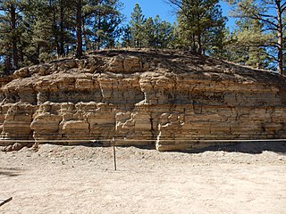
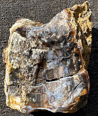
Reids Mistake Formation is a geologic formation in the Sydney Basin in eastern Australia. It may be seen at the Swansea Headland Petrified Forest, near Swansea, New South Wales. Formed in the late Permian, it is part of the Boolaroo Subgroup of the Newcastle Coal Measures.
A large petrified forest thought to date to the Paleocene at around 55 million years old is located on and around the grounds of Cherokee Ranch in Douglas County, Colorado. These Denver Basin fossils include plants similar to the modern laurel tree family. At least 40 large petrified logs have been discovered on the Cherokee Ranch property; the castle on the ranch site includes more than 4,000 pieces of petrified wood in its construction.
References
- ↑ David, T.W. Edgeworth (1907). "The Geology of the Hunter River Coal Measures, New South Wales". Memoirs of the Geological Survey of New South Wales (4).
- 1 2 "Swansea Headland Petrified Forest". Geological sites of NSW. Cartoscope. Retrieved 5 August 2021.
- 1 2 Organ, Michael; Byrnes, John (14 April 2009). "Fossil Pine Forest, Lake Macquarie". Michael Organ - Research Collection. Archived from the original on 4 April 2019. Retrieved 5 August 2021.
- ↑ Threlkeld, L.E. (1834). An Australian Grammar: comprehending the principles and natural rules of the language, as spoken by the Aborigines in the vicinity of Hunter's River, Lake Macquarie, &c., New South Wales. Sydney: Stephens & Stokes.
| In the world |
| ||||||||||||
|---|---|---|---|---|---|---|---|---|---|---|---|---|---|
| In fiction | |||||||||||||
33°05′16″S151°39′55″E / 33.087838°S 151.665144°E
| | This City of Lake Macquarie geography article is a stub. You can help Wikipedia by expanding it. |
| | This article about a specific Australian geological feature is a stub. You can help Wikipedia by expanding it. |