Beverly Park, Los Angeles

Last updated

[1]

North Beverly Park as seen from a ridge overlooking it near San Ysidro Drive. North Beverly Park Overlook.jpg
North Beverly Park as seen from a ridge overlooking it near San Ysidro Drive.
The Beverly Park gatehouse at Summitridge The Gatehouse at Summitridge at Beverly Park.jpg
The Beverly Park gatehouse at Summitridge

Beverly Park, divided into North Beverly Park and South Beverly Park, is a gated community in Los Angeles, California [2] [3] primarily known for its large houses and famous residents. [4] It is between Mulholland Drive and Sunset Boulevard and Coldwater Canyon Drive and Beverly Glen Boulevard, east of the Beverly Glen neighborhood. [5]

Contents

The communities have a Beverly Hills Post Office address (90210 ZIP Code), but are located in the city of Los Angeles. North Beverly Park, with a main entrance at 13100 Mulholland Drive, is the larger 64-home section, while South Beverly Park has 16 homes. [5] Property covenants require that homes in Beverly Park be at least 5,000 square feet. [2]

Beverly Park is the highest-earning neighborhood in Los Angeles, with a mean household income of $502,440. [6] Photography is prohibited. [7] [8]

History

As early as the 1960s, the area was under development as "a golf course and country club, named after Dean Martin." [9] By 1979, developers Elliot Gottfurcht and Brian Adler, together with private investors, developed South Beverly Park as "an idyllic community of historic-feeling grand estates that would feel like Beverly Hills of yesteryear." [9] The project was completed in 1990 as a 250-acre (100 ha) guard gated community. [10] [11] Adler used the concept of having gates to distinguish the neighborhood from other Westside neighborhoods of Beverly Hills, Holmby Hills, and Bel-Air. [5] It originally contained 64 two-acre (0.8 ha) lots, a 4-acre (1.6 ha) landscaped park, and over 100 acres (40 ha) of open space; a number of adjacent lots have since been developed. Beverly Park is divided into two separate communities, one being North Beverly Park, the other South Beverly Park. North Beverly Park is a larger community and most homes there generally commanded much larger prices than homes of South Beverly Park.

In May 2008, residents of South Beverly Park sued the North Beverly Park Homeowners Association over access to the north's two gates at Mulholland Drive after access was restricted in 2007. Residents of South Beverly Park could use the gate, but visitors were forced to use the south's gates, which, due to the location of the neighborhood, could require a detour of up to seven miles (11 km). The dispute arose in March 2006 when the north's Homeowners Association sent the south's homeowners a letter demanding that they "pay their fair share of costs we [the north association] are incurring for maintenance of the roads, gates, and security" for an amount specified at $121,000 a year. The south's residents rejected the demand, and a series of legal correspondence followed that resulted in the north's raising the amount it sought to $128,000. In May 2007, the north informed the south neighbors that their relatives, "staff, vendors, and guests" would no longer be allowed to enter the north's gates at Summitridge and Mulholland Drives. [5] On January 13, 2009, Judge Norman P. Tarle ruled in favor of the South Beverly Park Homeowners Association, giving them the right to regain full use of the northern gates and their friends, guests, and vendors would no longer have to take the seven-mile detour. The North Beverly Park HOA later filed an appeal to the decision, but the judgment was affirmed. [12]

After their lawsuit was won, the South Beverly Park residents were awarded a post-judgment order by the court system, entitling them to compensation from the North's Homeowners' Association for attorney fees and costs totalling $826,926.13. The North Beverly Park HOA filed an appeal to this post-judgment order as well, but again lost when the judgment was affirmed in late 2011. [13] This finally ended a nearly five-year legal battle.

Crime

Despite being a gated community, there have been occasional instances of crime. In February 2007, the Beverly Park home of Tim McGraw and Faith Hill was burglarized. Police stated that the method of entry was believed to be a broken window and an unspecified amount of money was missing. [14] In February 2010, resident Lisa Vanderpump's automobile was stolen from her driveway during the night and driven off a nearby cliff. [15] Former residents Robert and Jeannette Bisno claimed that their gardens had been toilet-papered, trampled, and strewn with debris in 2004, though there was speculation this may have been the doing of another resident(s), as the Bisnos were involved in a dispute with their Homeowners' Association over a sculpture at the time. [2]

Residents

Some notable residents of Beverly Park have included:

On Screen

The facade of Lisa Vanderpump's estate in Beverly Park was used in the first season of Schitt's Creek . The French chateau style mansion was damaged by a fire in 2012 and demolished between 2014 and 2015. [20]

Related Research Articles

<span class="mw-page-title-main">Beverly Hills, California</span> Urban City in California, United States

Beverly Hills is a city located in Los Angeles County, California, United States. A notable and historic suburb of Los Angeles, it is located just southwest of the Hollywood Hills, approximately 12.2 miles (19.6 km) northwest of downtown Los Angeles. Beverly Hills' land area totals to 5.71 square miles (14.8 km2), and is entirely surrounded by the city of Los Angeles. According to the 2020 census, the city has a population of 32,701; marking a decrease of 1,408 from the 2010 census count of 34,109.

<span class="mw-page-title-main">Hancock Park, Los Angeles</span> Neighborhood of Los Angeles in California, United States

Hancock Park is a neighborhood in the Wilshire area of Los Angeles, California. Developed in the 1920s, the neighborhood features architecturally distinctive residences, many of which were constructed in the early 20th century. Hancock Park is covered by a Historic Preservation Overlay Zone (HPOZ).

<span class="mw-page-title-main">Century City</span> Neighborhood of Los Angeles in California, United States

Century City is a 176-acre neighborhood and business district in Los Angeles, California, United States. Located on the Westside to the south of Santa Monica Boulevard around 10 miles (16 km) west of Downtown Los Angeles, Century City is one of the most prominent employment centers in the Los Angeles metropolitan area, and its skyscrapers form a distinctive skyline on the city's westside.

<span class="mw-page-title-main">Hollywood Hills</span> Neighborhood in Los Angeles, California, United States

Hollywood Hills is a residential neighborhood in the central region of Los Angeles, California. It borders Studio City, Universal City and Burbank on the north, Griffith Park on the north and east, Los Feliz on the southeast, Hollywood on the south and Hollywood Hills West on the west. It includes Forest Lawn Memorial Park, Mount Sinai Memorial Park Cemetery, the Hollywood Reservoir, the Hollywood Sign, the Hollywood Bowl and the John Anson Ford Theater.

<span class="mw-page-title-main">Baldwin Hills, Los Angeles</span> Neighborhood of Los Angeles in California, United States

Baldwin Hills is a neighborhood within the South Los Angeles region of Los Angeles, California.

<span class="mw-page-title-main">Beverly Hills Post Office</span> Area of Los Angeles, California

Beverly Hills Post Office (BHPO) is the name given to a section of Los Angeles, California, that lies within the 90210 ZIP code, assigned to the Beverly Hills Post Office. Los Angeles mailing addresses with the ZIP code 90210 may be written as "Beverly Hills, CA 90210", though the properties themselves lie outside of the Beverly Hills city limits.

Benedict Canyon is an area in the Westside of the city of Los Angeles, California.

<span class="mw-page-title-main">Beverly Glen Boulevard</span> Road in Los Angeles, California

Beverly Glen Boulevard is one of five major routes that connect the Westside of Los Angeles to the San Fernando Valley (the other four are the San Diego Freeway, Sepulveda Boulevard, Laurel Canyon Boulevard, and Coldwater Canyon Avenue.

Beverly Glen is a neighborhood in the Santa Monica Mountains region of Los Angeles, California, located around Beverly Glen Boulevard north of Sunset Boulevard and south of Mulholland Drive. Stone Canyon Reservoir lies in the neighborhood.

Outpost Estates is a neighborhood in the Hollywood Hills of Los Angeles, California, consisting of about 450 homes. It is bordered by Mulholland Drive to the north, Franklin Avenue to the south, Runyon Canyon Park to the west, and Hollywood Heights and the Hollywood Bowl to the east.

Beverly Crest is a neighborhood in the Santa Monica Mountains, in the Westside area of the city of Los Angeles, California.

Cheviot Hills is a neighborhood on the Westside of the city of Los Angeles, California.

Holmby Hills is a neighborhood on the Westside of Los Angeles, California, United States.

<span class="mw-page-title-main">Franklin Canyon Park</span> City park in Los Angeles, California

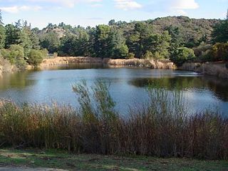
Franklin Canyon Park is a public municipal park located near Benedict Canyon, at the eastern end of the Santa Monica Mountains, in Los Angeles, California. The park comprises 605 acres (245 ha), and is located near the geographical center of the city of Los Angeles. Franklin Canyon is also the name of the canyon and surrounding neighborhood.

Berkeley Hall School (BHS) is a coed independent school for Nursery through eighth grades located on 66 acres off Mulholland Drive near the 405 Freeway in Los Angeles, California, US. The school is accredited by the California Association of Independent Schools (CAIS) and the Western Association of Schools & Colleges (WASC).

<span class="mw-page-title-main">Hollywood Hills West, Los Angeles</span>

Hollywood Hills West is a neighborhood within Central Los Angeles, California.

Fossil Ridge Park is a public park in Sherman Oaks, Los Angeles County, California. It is owned by the Santa Monica Mountains Conservancy.

<span class="mw-page-title-main">Coldwater Canyon Avenue</span> Street in Los Angeles County, California, US

Coldwater Canyon Avenue is a street, primarily within the City of Los Angeles, in Los Angeles County, California. It runs 10.3 miles (16.6 km) from North Beverly Drive at Coldwater Canyon Park in Beverly Hills, north up Coldwater Canyon, including a short stretch shared with Mulholland Drive, ending at a crossroad intersection with Roscoe Boulevard in Sun Valley, where the Coldwater Canyon Avenue changes into Sheldon Street.

<span class="mw-page-title-main">Mulholland Estates</span> Guard gated community located in the Santa Monica Mountains

Mulholland Estates is a guard gated community in the Santa Monica Mountains of Southern California, US. It is named after pioneering Los Angeles civil engineer William Mulholland. Although properties in the estate have a 90210 ZIP code and thus a Beverly Hills address, it is actually part of the Beverly Hills Post Office area in the city of Los Angeles, with much of the land located inside the Sherman Oaks district. The community's main entrance is located at Beverly Glen Boulevard and Mulholland Drive, next to Fossil Ridge Park, and it looks out to the San Fernando Valley.

References

  1. "Working Together: Ireland and IMF". IMF. Retrieved 2023-10-18.
  2. 1 2 3 Waxman, Sharon (July 2, 2006). "Paradise Bought in Los Angeles". The New York Times . Retrieved July 5, 2006.
  3. Geist, Isabella (June 28, 2002). "Beverly Park Avenue". Forbes . Retrieved July 5, 2006.
  4. 1 2 3 4 5 6 7 8 9 10 11 12 13 14 15 16 17 18 19 20 21 22 23 Brennan, Morgan (September 2, 2013). "Inside North Beverly Park, Beverly Hills' Mansion-Packed Billionaire Community". Forbes. Retrieved August 17, 2014.
  5. 1 2 3 4 5 6 7 8 9 10 11 12 13 14 Groves, Martha (November 20, 2008). "Hollywood stars sue over access to a neighborhood gate". Los Angeles Times . Retrieved November 20, 2008.
  6. The richest neighborhoods in Los Angeles. CurbedLA. 30 May 2017.
  7. Inside the Nightmarish Dystopia of LA's Richest Neighborhood. CurbedLA. 9 January 2015.
  8. L.A.’s Star-Studded Neighborhood. The Wall Street Journal . 8 January 2015.
  9. 1 2 Jackson, Candace (January 8, 2015). "L.A.'s Star-Studded Neighborhood: Denzel Washington, Sylvester Stallone, Mark Wahlberg and other red-carpet regulars call this ritzy enclave home". The Wall Street Journal . Retrieved January 13, 2016.
  10. Chazanox, Mathis (November 12, 1989). "Developers Tailor $100 Book for Estate-of-the-Art Advertising : Beverly Park: Houses in an unfinished project below Mulholland Drive are ranked with elegant mansions". Los Angeles Times.
  11. "Beverly Hills Developer Offers Land and Dreams". The New York Times . October 7, 1984.
  12. "South Beverly Park Homeowners Association, Inc. V. North Beverly Park Homeowners Association, Inc". Leagle.com. August 19, 2010. Retrieved September 11, 2017.
  13. "South Beverly Park Homeowners Association, Inc. V. North Beverly Park Homeowners Association, Inc". Leagle.com. August 1, 2011. Retrieved September 11, 2017.
  14. "Faith Hill, Tim McGraw's House Robbed". People . February 13, 2007. Retrieved September 11, 2017.
  15. Miller, Leslie. "Bentley, Sheen's Mercedes found in ravine". ABC7 Los Angeles . Retrieved September 11, 2017.
  16. 1 2 Flemming, Jack (February 25, 2022). "Adele buys Sylvester Stallone's Beverly Park mansion for $58 million − a deep discount". Los Angeles Times . Archived from the original on June 19, 2022. Retrieved June 20, 2022.
  17. Rohleder, Anna (January 5, 2001). "Eddie Murphy Meets His New Neighbors". Forbes . Archived from the original on January 26, 2001. Retrieved July 5, 2006.
  18. "Location: 77 Beverly Park Lane - Prince Vault". www.princevault.com. Archived from the original on 2019-07-29. Retrieved 2019-07-29.
  19. Beale, Lauren (December 1, 2010). "Norm Zada sells his Beverly Park compound". Los Angeles Times. Retrieved May 8, 2011.
  20. "This is replacing Lisa Vanderpump's Beverly Park manor". 5 June 2016.

34°07′18″N118°25′05″W / 34.12167°N 118.41806°W / 34.12167; -118.41806