Bickley, Western Australia

Last updated

Bickley
Perth,  Western Australia
Bickley, Western Australia
Coordinates 32°00′29″S116°05′28″E / 32.008°S 116.091°E / -32.008; 116.091
Population713 (SAL 2021) [1]
Postcode(s) 6076
LGA(s) City of Kalamunda
State electorate(s) Kalamunda
Federal division(s) Hasluck
Suburbs around Bickley:
Kalamunda Piesse Brook Hacketts Gully
Walliston Bickley Reservoir
Carmel Pickering Brook Pickering Brook

Bickley is a suburb located within the City of Kalamunda, in Perth, Western Australia.

Contents

It is situated on the Darling Scarp and is known for the brook of the same name. [2]

Before 1949 it was a stopping place on the Upper Darling Range Railway. It was originally known as "Heidelburg" or "Heidelberg", [3] [ clarification needed ] but during World War I, Western Australian Government Railways and Tramways renamed it "Bickley" after a local pioneer Wallace Bickley. [4]

It has been the site of holiday and other sorts of camps. [5]

The Seven Network and Australian Broadcasting Corporation's Perth television transmission towers have been located there since the founding of television in Perth in 1959. [6] [7]

Perth Observatory, originally situated in West Perth is also currently located in Bickley. [8]

It is also one of the major meteorological stations within the Perth Metropolitan Area due to its length of time of operation and location on the Darling Scarp. [9]

It is also the location of water reservoirs. [10] [11]

Climate

Bickley has a Mediterranean climate (Köppen climate classification Csa), like the rest of Perth. Bickley has one of the highest average annual rainfalls for the Perth metropolitan region, and it experiences cooler nights than the rest of Perth, meaning that Bickley has a microclimate. [12] [13]

Climate data for Bickley
MonthJanFebMarAprMayJunJulAugSepOctNovDecYear
Record high °C (°F)41.8
(107.2)
42.0
(107.6)
41.0
(105.8)
36.5
(97.7)
31.0
(87.8)
22.0
(71.6)
22.0
(71.6)
26.6
(79.9)
30.5
(86.9)
35.8
(96.4)
38.9
(102.0)
41.0
(105.8)
42.0
(107.6)
Mean maximum °C (°F)38.9
(102.0)
38.3
(100.9)
36.8
(98.2)
31.2
(88.2)
25.8
(78.4)
20.9
(69.6)
19.5
(67.1)
21.5
(70.7)
24.8
(76.6)
30.8
(87.4)
34.6
(94.3)
37.8
(100.0)
39.9
(103.8)
Mean daily maximum °C (°F)30.5
(86.9)
30.5
(86.9)
27.9
(82.2)
23.6
(74.5)
19.3
(66.7)
16.2
(61.2)
15.1
(59.2)
16.0
(60.8)
17.6
(63.7)
21.2
(70.2)
25.1
(77.2)
28.2
(82.8)
22.6
(72.7)
Mean daily minimum °C (°F)15.4
(59.7)
15.9
(60.6)
14.6
(58.3)
12.7
(54.9)
10.1
(50.2)
8.1
(46.6)
7.2
(45.0)
7.6
(45.7)
8.2
(46.8)
9.8
(49.6)
11.9
(53.4)
13.8
(56.8)
11.3
(52.3)
Mean minimum °C (°F)9.8
(49.6)
10.3
(50.5)
8.9
(48.0)
7.4
(45.3)
5.5
(41.9)
3.9
(39.0)
3.0
(37.4)
3.2
(37.8)
3.5
(38.3)
4.9
(40.8)
7.0
(44.6)
8.4
(47.1)
2.4
(36.3)
Record low °C (°F)8.0
(46.4)
8.0
(46.4)
5.0
(41.0)
4.4
(39.9)
3.0
(37.4)
2.4
(36.3)
1.0
(33.8)
1.0
(33.8)
1.0
(33.8)
3.0
(37.4)
4.0
(39.2)
5.0
(41.0)
1.0
(33.8)
Average rainfall mm (inches)20.5
(0.81)
20.7
(0.81)
26.1
(1.03)
54.7
(2.15)
130.8
(5.15)
198.1
(7.80)
216.8
(8.54)
176.8
(6.96)
123.2
(4.85)
66.1
(2.60)
40.6
(1.60)
14.6
(0.57)
1,080.4
(42.54)
Average precipitation days3.32.84.37.412.717.118.016.614.59.46.53.6116.2
Average afternoon relative humidity (%) (at 15:00)35343949586768656051443851
Source: Bureau of Meteorology [9] [14] [15]
Temperatures: 1994–2020; Rain data: 1969–2020; Relative humidity: 1994–2010

See also

Related Research Articles

<span class="mw-page-title-main">Perth</span> Capital city of Western Australia

Perth is the capital and largest city of Western Australia. It is the fourth most populous city in Australia and Oceania, with a population of nearly 2.2 million within Greater Perth. It is part of the South West Land Division of Western Australia, with the majority of Perth's metropolitan area on the Swan Coastal Plain between the Indian Ocean and the Darling Scarp. The city has expanded outward from the original British settlements on the Swan River, upon which its central business district and port of Fremantle are situated.

<span class="mw-page-title-main">Darling Scarp</span> Scarp east of Perth, Western Australia

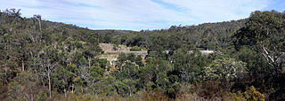
The Darling Scarp, also referred to as the Darling Range or Darling Ranges, is a low escarpment running north–south to the east of the Swan Coastal Plain and Perth, Western Australia. The escarpment extends generally north of Bindoon, to the south of Pemberton. The adjacent Darling Plateau goes easterly to include Mount Bakewell near York and Mount Saddleback near Boddington. It was named after the Governor of New South Wales, Lieutenant-General Ralph Darling.

<span class="mw-page-title-main">City of Gosnells</span> Local government area in Perth, Western Australia

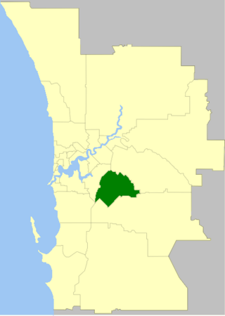
The City of Gosnells is a local government area in the southeastern suburbs of the Western Australian capital city of Perth, located northwest of Armadale and about 20 kilometres (12 mi) southeast of Perth's central business district. The City covers an area of 128 square kilometres (49.42 sq mi), a portion of which is state forest rising into the Darling Scarp to the east, and had a population of approximately 118,000 at the 2016 Census. The largest activity centre in the City is the Central Maddington shopping centre. District centres exist in the Gosnells town centre and Thornlie.

<span class="mw-page-title-main">Kalamunda, Western Australia</span> Suburb of Perth, Western Australia

Kalamunda is a town and eastern suburb of Perth, Western Australia, located in the Darling Scarp at the eastern limits of the Perth metropolitan area.

<span class="mw-page-title-main">Perth Observatory</span> Observatory in Bickley, Western Australia

The Perth Observatory is the name of two astronomical observatories located in Western Australia (WA). In 1896, the original observatory was founded in West Perth on Mount Eliza overlooking the city of Perth. Due to the city's expansion, the observatory moved to Bickley in 1965. The new Perth Observatory is sometimes referred to as Bickley Observatory.

<span class="mw-page-title-main">Swanbourne, Western Australia</span> Suburb of Perth, Western Australia

Swanbourne is a western coastal suburb of Perth, Western Australia, located within the City of Nedlands. It is an affluent, upper middle class residential area with older Federation style homes, many being renovated. The suburb was established in the late 19th century. New housing estates have been built recently through the redevelopment of areas such as the Swanbourne Senior High School, Swanbourne Primary School and Lakeway Drive-In Cinema sites.

<span class="mw-page-title-main">Pemberton, Western Australia</span> Town in Western Australia

Pemberton is a town in the South West region of Western Australia, named after original settler Pemberton Walcott.

<span class="mw-page-title-main">Bullsbrook, Western Australia</span> Suburb of Perth, Western Australia

Bullsbrook is a northern suburb of Perth, Western Australia in the outer metropolitan area. It is located in the City of Swan. The original Bullsbrook townsite is located slightly west of the current town, on the 17 km mark of the Midland Railway. Bullsbrook is also home to the RAAF Pearce airbase, a major training facility for the Royal Australian Air Force. The suburb is situated on the Great Northern Highway, 25 kilometres north of the Midland Strategic Regional Centre. It is well serviced by several major transport networks including the Great Northern Highway, Railway Parade and the Brand Highway to the north, Chittering Road to the east and Neaves Road to the west. Bullsbrook is also adjacent to the State rail network, providing an opportunity for the development of an intermodal freight transport hub. The site is further strengthened by linkage to the planned Perth-Darwin National Highway via Stock Road.

<span class="mw-page-title-main">Karragullen, Western Australia</span> Suburb of Perth, Western Australia

Karragullen is a suburb of Perth, Western Australia, located within the City of Armadale. Its postcode is 6111.

<span class="mw-page-title-main">Orange Grove, Western Australia</span> Suburb of Perth, Western Australia

Orange Grove is a suburb of Perth, Western Australia in the City of Gosnells.

<span class="mw-page-title-main">Wattle Grove, Western Australia</span> Suburb of Perth, Western Australia

Wattle Grove is a suburb of Perth, Western Australia, located within the City of Kalamunda.

<span class="mw-page-title-main">Serpentine Dam (Western Australia)</span> Dam in Western Australia

The Serpentine Dam is a major water supply dam for Perth, Western Australia. The dam is used to store water that is released at a controlled rate to regulate the level in the Serpentine Pipehead Dam reservoir, which in turn feeds water to the metropolitan trunk main network depending on demand. Construction of the dam was completed in 1961.

<span class="mw-page-title-main">Goldfields Water Supply Scheme</span> Pipeline and dam project in Western Australia

The Goldfields Water Supply Scheme is a pipeline and dam project that delivers potable water from Mundaring Weir in Perth to communities in Western Australia's Eastern Goldfields, particularly Coolgardie and Kalgoorlie. The project was commissioned in 1896 and completed in 1903.

<span class="mw-page-title-main">Perth Hills</span> Place in Western Australia

Perth Hills is a term used primarily for marketing purposes to identify the part of the Darling Scarp and hinterland east of the scarp that lies within the Shire of Mundaring, City of Swan, and the City of Kalamunda and as part of the constituent bodies belonging to the Eastern Metropolitan Regional Council of Perth, Western Australia.

<span class="mw-page-title-main">Eyre Bird Observatory</span> Bird observatory on the south east coast of Western Australia

Eyre Bird Observatory is an educational, scientific and recreational facility in the Nuytsland Nature Reserve, Western Australia. Cocklebiddy is the nearest locality on the Eyre Highway, 49 km (30 mi) to the north. It is in the Hampton bioregion, which is sandwiched between the Nullarbor Plain to the north and the Great Australian Bight to the south, in one of the least populated places on the Australian continent. It was established in 1977 by Birds Australia in the disused Eyre Telegraph Station as Australia's first bird observatory, to provide a base for the study and enjoyment of the birds of the area.

<span class="mw-page-title-main">City of Kalamunda</span> Local government area in Western Australia

The City of Kalamunda is a local government area in the eastern metropolitan region of the Western Australian capital city of Perth about 25 kilometres (16 mi) east of Perth's central business district. The area covers 324 square kilometres (125 sq mi), much of which is state forest rising into the Darling Scarp to the east. As of 2021, the city had a population of 58,762.

Red Hill is a suburb of Perth, Western Australia. It has Toodyay Road pass through it on the way up the Darling Scarp. It is in the City of Swan local government area. At the 2011 Australian Census the suburb recorded a population of 98.

Bickley Pumpback Dam, known also as the Lower Bickley Brook reservoir, is located in Perth, Western Australia.

Lesmurdie Senior High School is a public co-educational high school in the Perth suburb of Lesmurdie, Western Australia.

Perth, the capital city of the state of Western Australia, has a Mediterranean climate, with hot, dry summers and mild, wet winters. February is the hottest month of the year, with an average high of 31.6 °C (88.9 °F), and July is the coldest month of the year, with an average low of 7.9 °C (46.2 °F). 77% of rain in Perth falls between May and September. Perth has an average of 8.8 hours of sunshine per day, which equates to around 3,200 hours of annual sunshine, and 138.7 clear days annually, making it the sunniest capital city in Australia.

References

  1. Australian Bureau of Statistics (28 June 2022). "Bickley (suburb and locality)". Australian Census 2021 QuickStats. Retrieved 28 June 2022.  OOjs UI icon edit-ltr-progressive.svg
  2. Tian, Wee Heng; University of Western Australia. Faculty of Science (1963), Geology and petrology of the Bickley Brook area , retrieved 23 February 2015
  3. "Heidelberg Estate". State Heritage Office. Government of Western Australia. 4 January 2017. Retrieved 1 December 2019.
  4. "History of metropolitan suburb names – B". Western Australian Land Information Authority. Archived from the original on 16 March 2022. Retrieved 10 October 2008.
  5. Cornish, Patrick; Western Australia. Dept. for Youth, Sport and Recreation (1985), The origins of Bickley Camp, Department for Youth, Sport and Recreation, retrieved 23 February 2015
  6. -mention of the Tuart Hill Studios and Bickley Transmission for Channel 7
  7. http://ozdigitaltv.com/transmitters/WA/402-Bickley-Carmel-Walliston - current transmitters
  8. "Contact Us". Perth Observatory . Retrieved 6 November 2018.
  9. 1 2 "Climate statistics for Australian locations – Bickley". Bureau of Meteorology. Retrieved 15 July 2020.
  10. "LOWER BICKLEY BROOK RESERVOIR". Western Mail (Perth, WA : 1885 - 1954) . Perth, WA: National Library of Australia. 20 October 1921. p. 25. Retrieved 23 February 2015.
  11. Western Australia. Dept. of Water; Western Australia. Water Resources Division (2006), Bickley Reservoir catchment area drinking water source protection plan : integrated water supply system, Dept. of Water, retrieved 23 February 2015
  12. Pascual Juanola, Marta (9 July 2020). "The hidden tourism gems that could help keep WA's economy pumping". WA Today. Retrieved 16 July 2020.
  13. "A few things that may surprise you about the Bickley Valley!". Dvine Wine Tours. Retrieved 16 July 2020.
  14. "Monthly highest temperature – Bickley". Bureau of Meteorology. Retrieved 15 July 2020.
  15. "Monthly lowest temperature – Bickley". Bureau of Meteorology. Retrieved 15 July 2020.

Commons-logo.svg Media related to Bickley Brook Reservoir at Wikimedia Commons