Gooseberry Hill, Western Australia

Last updated

Gooseberry Hill
Perth,  Western Australia
Gooseberry hill 01 gnangarra.JPG
Gooseberry Hill viewed from
the Kalamunda Zig Zag
Gooseberry Hill, Western Australia
Coordinates 31°57′14″S116°02′56″E / 31.954°S 116.049°E / -31.954; 116.049
Population3,323 (SAL 2021) [1]
Postcode(s) 6076
Location25 km (16 mi) from Perth
LGA(s) City of Kalamunda
State electorate(s) Kalamunda
Federal division(s) Hasluck
Suburbs around Gooseberry Hill:
Hazlemere Helena Valley Darlington
Bushmead Gooseberry Hill Piesse Brook
Forrestfield Kalamunda Kalamunda

Gooseberry Hill is a suburb of Perth, Western Australia, located within the City of Kalamunda. It is the site of Gooseberry Hill National Park.

Contents

It is located at the highest point south of the departure of the Helena River from the Darling Scarp on to the Swan Coastal Plain. It is often associated with the railway formation of the Kalamunda Zig Zag and the northernmost high feature of Statham's Quarry, which lie on the north west of the locality within national park land.

In 1861, Benjamin Robins purchased 40 acres (16 ha) of land in the area. [2] In 1878 surveyor Henry Samuel Ranford recorded the name of the eponymous hill as "Gooseberry Hill" ; that name, derived from the presence of cape gooseberries in the area, referred to the Kalamunda area generally in the late 19th century. [3] [4] [5] The townsite was officially gazetted on 8 June 1959. [3]

Gooseberry Hill was the location of a war-time tragedy when a United States Navy C-47 Skytrain (DC-3) plane crashed in heavy fog on 19 April 1945 after taking off from Guildford Airport (later Perth Airport). [6] All of the ten US servicemen and three US Red Cross women on board were killed. [7] [8] The plane crashed between Gooseberry Hill Road and Lansdown Road, 4.5 miles (7.2 km) from the end of the take-off runway, having travelled in an almost straight course to the point of impact. [6]

The suburb contains two schools, Gooseberry Hill Primary School, a government school established in 1972, and Mary's Mount Primary School, a Catholic school established in 1921. [9] [10]

Transport

Bus

Related Research Articles

<span class="mw-page-title-main">Tuart Hill, Western Australia</span> Suburb of Perth, Western Australia

Tuart Hill is a suburb of Perth, Western Australia.

<span class="mw-page-title-main">Kalamunda, Western Australia</span> Suburb of Perth, Western Australia

Kalamunda is a town and eastern suburb of Perth, Western Australia, located in the Darling Scarp at the eastern limits of the Perth metropolitan area.

<span class="mw-page-title-main">Forrestfield, Western Australia</span> Suburb of Perth, Western Australia

Forrestfield is a suburb of the City of Kalamunda in Western Australia. It lies 15 kilometres to the south-east of Perth at the base of the Darling Scarp and the southern border of Perth Airport.

<span class="mw-page-title-main">Bellevue, Western Australia</span> Suburb of Perth, Western Australia

Bellevue is an eastern suburb of Perth, Western Australia in the local government areas of the City of Swan and the Shire of Mundaring. It is at the foot of the slopes of Greenmount, a landmark on the Darling Scarp that is noted in the earliest of travel journals of the early Swan River Colony.

<span class="mw-page-title-main">Burswood, Western Australia</span> Suburb of Perth, Western Australia

Burswood is an inner southeastern suburb of Perth, Western Australia, located immediately across the Swan River from Perth's central business district (CBD). Its local government area is the Town of Victoria Park. Burswood is the location of the State Tennis Centre, Perth Stadium, Belmont Park Racecourse, and the Crown Perth casino and hotel complex.

<span class="mw-page-title-main">Alexander Heights, Western Australia</span> Suburb of Perth, Western Australia

Alexander Heights is a suburb of Perth, Western Australia within the City of Wanneroo.

<span class="mw-page-title-main">Welshpool, Western Australia</span> Suburb of Perth, Western Australia

Welshpool is an inner southeastern suburb of Perth, Western Australia, located mostly within the City of Canning and partially within the Town of Victoria Park.

<span class="mw-page-title-main">Canning Vale, Western Australia</span> Suburb of Perth, Western Australia

Canning Vale is a southern suburb of Perth, 22 km (13.7 mi) from the central business district. Its local government areas are the City of Canning and the City of Gosnells.

<span class="mw-page-title-main">Bentley, Western Australia</span> Suburb of Perth, Western Australia

Bentley is a southern suburb of Perth, the capital city of Western Australia, 8 kilometres (5.0 mi) southeast of Perth's central business district. Its local government areas are the City of Canning and the Town of Victoria Park. Bentley is home to the main campus of Curtin University and Technology Park.

East Cannington is a southeastern suburb of Perth, Western Australia. Its local government area is the City of Canning.

<span class="mw-page-title-main">Queens Park, Western Australia</span> Suburb of Perth, Western Australia

Queens Park is a suburb of Perth, Western Australia, located within the City of Canning. Its postcode is 6107.

<span class="mw-page-title-main">Southern River, Western Australia</span> Suburb of Perth, Western Australia

Southern River is a suburb of Perth, Western Australia, located within the City of Gosnells.

High Wycombe is a suburb of Perth, Western Australia, within the City of Kalamunda. High Wycombe lies east of the Perth CBD at the base of the Darling Scarp. Formerly part of Maida Vale, the suburb was officially declared on 2 June 1978; its name, which was first used in 1958 by a subdivider, Western Agencies, refers to the town in Buckinghamshire where one of the partners in the firm was born.

<span class="mw-page-title-main">Lesmurdie, Western Australia</span> Suburb of Perth, Western Australia

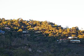
Lesmurdie is a suburb of Perth, Western Australia, located within the City of Kalamunda. It was established in 1897 by Archibald Sanderson, a politician and journalist, who began buying properties in the area from the Canning Jarrah Timber Company to build up a rural retreat and fruit-growing property. He named it after Lesmurdie Cottage, a shooting box near Dufftown, Scotland that his father had rented. It was officially gazetted on 8 June 1959.

Maida Vale is a suburb of Perth, Western Australia, located within the City of Kalamunda. Kalamunda Road runs through the suburb. Its first European settler was William Henry Mead, who arrived in 1873, built a home in the Ridge Hill area and established the orchard Orangedale. It was named in 1910 after a property name of another settler, WH McCormack. The name is believed to be derived from the eponymous area of West London., which is itself named after the 1806 Battle of Maida.

<span class="mw-page-title-main">Helena Valley, Western Australia</span> Suburb of Perth, Western Australia

Helena Valley is the name of a river valley and a locality in the foothills of the Darling Scarp in Perth, Western Australia.

<span class="mw-page-title-main">Perth Airport (suburb)</span> Suburb of Perth, Western Australia

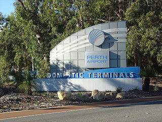
Perth Airport is an eastern suburb of Perth, the capital city of Western Australia. Its local government areas are the City of Belmont, the City of Swan (north) and the City of Kalamunda (east). It is located approximately 12 km east of the central business district. The suburb is the home of Perth Airport, the main international airport of Perth.

<span class="mw-page-title-main">South Guildford, Western Australia</span> Suburb of Perth, Western Australia

South Guildford is a suburb of Perth, Western Australia, located in the City of Swan local government area.

<span class="mw-page-title-main">Perth (suburb)</span> Suburb of Perth, Western Australia

Perth is a suburb in the Perth metropolitan region, Western Australia that includes both the central business district of the city, and a suburban area spreading north to the northern side of Hyde Park. It does not include the separate suburbs of Northbridge or Highgate. Perth is split between the City of Perth and the City of Vincent local authorities, and was named after the city of the same name in Scotland.

<span class="mw-page-title-main">Midland, Western Australia</span> Suburb of Perth, Western Australia

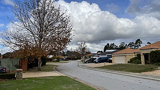
Midland is a suburb in the Perth metropolitan region, as well as the regional centre for the City of Swan local government area that covers the Swan Valley and parts of the Darling Scarp to the east. It is situated at the intersection of Great Eastern Highway and Great Northern Highway. Midland is almost always regarded as a suburb of Perth, being only 16 km (10 mi) away from the city centre.

References

  1. Australian Bureau of Statistics (28 June 2022). "Gooseberry Hill (suburb and locality)". Australian Census 2021 QuickStats. Retrieved 28 June 2022.  OOjs UI icon edit-ltr-progressive.svg
  2. "A Taste of Our History" (PDF). Kalamunda & Districts Historical Society. Retrieved 13 October 2019.
  3. 1 2 "History of metropolitan suburb names – G". Western Australian Land Information Authority. Archived from the original on 16 March 2022. Retrieved 13 October 2019.
  4. "Ranford Family" (PDF). State Library of Western Australia . Retrieved 13 October 2019.
  5. "6.0 Thematic History". MUNICIPAL HERITAGE INVENTORY 2019 (PDF). City of Kalamunda. May 2019. Retrieved 13 October 2019.
  6. 1 2 "Crash of a US Navy R4D-5 (DC-3), "Blue Goose" at Gooseberry Hill, Kalamunda near Perth, WA on 19 April 1945". ozcrashes.
  7. Thirteen dead : U.S.N. transport plane crashes at Gooseberry Hill. (19 April 1945, a United States Navy C47 transport airplane crashed at Gooseberry Hill. Killed US servicemen, 1 officer of the Royal Navy and 3 U.S. Red Cross workers).The West Australian, 20 April 1945, p.6f
  8. Crash victims, burial yesterday The funeral for the victims of the crash of the C47 transport airplane at Gooseberry Hill, 19 April 1945. The U.S. servicemen and the Royal Navy officer buried at Karrakatta, the 3 Red Cross workers repatriated to Sydney. The West Australian, 24 April 1945, p.4e
  9. "Gooseberry Hill Primary School". Gooseberry Hill Primary School. Retrieved 13 October 2019.
  10. "Our History". Mary's Mount Primary School. Retrieved 13 October 2019.
  11. "Route 274". Bus Timetable 109 (PDF). Transperth. 25 August 2023 [effective from 20 November 2023].
  12. "Route 275". Bus Timetable 109 (PDF). Transperth. 25 August 2023 [effective from 20 November 2023].
  13. "Route 276". Bus Timetable 109 (PDF). Transperth. 25 August 2023 [effective from 20 November 2023].
  14. "Route 307". Bus Timetable 96 (PDF). Transperth. 16 January 2024 [effective from 4 February 2024].