
Pendleton County is a county located in the U.S. state of West Virginia. As of the 2010 census, the population was 7,695, making it the fifth-least populous county in West Virginia. Its county seat is Franklin. The county was created by the Virginia General Assembly in 1788 from parts of Augusta, Hardy, and Rockingham Counties and was named for Edmund Pendleton (1721–1803), a distinguished Virginia statesman and jurist. Pendleton County was strongly pro-Confederate during the American Civil War; however, there were pockets of Unionists who supported the state government in Wheeling.

The Monongahela National Forest is a national forest located in the Allegheny Mountains of eastern West Virginia, USA. It protects over 921,000 acres of federally owned land within a 1,700,000 acres proclamation boundary that includes much of the Potomac Highlands Region and portions of 10 counties.

The Dolly Sods Wilderness — originally simply Dolly Sods — is a U.S. Wilderness Area in the Allegheny Mountains of eastern West Virginia, US, and is part of the Monongahela National Forest (MNF) of the U.S. Forest Service (USFS).

The South Branch Potomac River has its headwaters in northwestern Highland County, Virginia near Hightown along the eastern edge of the Allegheny Front. After a river distance of 139 miles (224 km), the mouth of the South Branch lies east of Green Spring in Hampshire County, West Virginia where it meets the North Branch Potomac River to form the Potomac.
The Potomac Highlands of West Virginia centers on five West Virginian counties in the upper Potomac River watershed in the western portion of the state's Eastern Panhandle, bordering Maryland and Virginia. Because of geographical proximity, similar topography and landscapes, and shared culture and history, the Potomac Highlands region also includes Pocahontas, Randolph, and Tucker counties, even though they are in the Monongahela River or New River watersheds and not that of the Potomac River.
Lunice Creek is a 7.3-mile-long (11.7 km) tributary of the South Branch Potomac River, belonging to the Potomac River and Chesapeake Bay watersheds. The creek is located in Grant County, West Virginia. Lunice Creek is created by its North and South Forks and empties into the South Branch at Petersburg.

Cherry Grove is an unincorporated community located in Pendleton County, West Virginia, United States. Cherry Grove lies within the Monongahela National Forest at the confluence of Big Run with the North Fork South Branch Potomac River.

Seneca Creek is a 19.6-mile-long (31.5 km) tributary of the North Fork of the South Branch of the Potomac River located entirely within Pendleton County, West Virginia, USA.
Kettle Creek is a 7.3-mile-long (11.7 km) tributary stream of the South Fork South Branch Potomac River in Hardy and Pendleton counties in West Virginia's Eastern Panhandle. Kettle Creek rises on Mitchell Knob and flows north along the eastern flanks of Sweedlin Hill through Sweedlin Valley in the George Washington National Forest.
Mill Creek is a 5.3-mile-long (8.5 km) tributary stream of the North Fork South Branch Potomac River in Pendleton County, West Virginia. Mill Creek rises on the western flanks of North Fork Mountain and from there, flows north through Germany Valley. Its confluence with the North Fork lies at Hinkle Gap between Germany and Harman Knobs.

North Fork Mountain is a quartzite-capped mountain ridge in the Ridge and Valley physiographic province of the Allegheny Mountains of eastern West Virginia, USA. Kile Knob, at 4,588 feet, is the mountain's highest point, and Panther Knob and Pike Knob are nearly as high.

The Silurian Tuscarora Formation — also known as Tuscarora Sandstone or Tuscarora Quartzite — is a mapped bedrock unit in Pennsylvania, Maryland, West Virginia, and Virginia, USA.

The Sinks of Gandy — also called the Sinks of Gandy Creek, or simply "The Sinks" — are a modestly celebrated cave and underground stream at Osceola in eastern Randolph County, West Virginia, United States. The Sinks are on private property adjacent to Monongahela National Forest.

Blackwater Canyon is a rugged, heavily wooded, eight-mile (13 km) long gorge carved by the Blackwater River in the Allegheny Mountains of eastern West Virginia, USA. For many years, it has been the object of controversy as environmental activists have contended with industrial interests over its ultimate status.
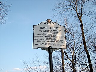
Hoye-Crest is a summit along Backbone Mountain just inside of Garrett County, Maryland. It is the highest natural point in Maryland at an elevation of 3,360 feet (1,020 m).

Smoke Hole Canyon — traditionally called The Smoke Holes and later simply Smoke Hole — is a rugged 20 miles (32 km) long gorge carved by the South Branch Potomac River in the Allegheny Mountains of eastern West Virginia, United States. The area is rather isolated and remote with parts accessible only by boat or on foot.

The Cranberry Wilderness is a 47,815-acre (19,350 ha) U.S. wilderness area in the Monongahela National Forest of southeast West Virginia, United States. Its name derives from the nearby Cranberry Glades as well as from the Cranberry River and Cranberry Mountain. In addition to being wilderness, it is a designated black bear sanctuary.

The Laurel Fork is a 15.7-mile-long (25.3 km) stream in Virginia and West Virginia, United States. The stream flows north from Highland County, Virginia, where its source and the majority of its length is located, to its mouth in Pendleton County, West Virginia. Laurel Fork is a tributary to the North Fork South Branch Potomac River, making it a part of the Potomac River watershed. The area surrounding Laurel Fork is home to several plant and animal species found nowhere else in Virginia, and is a prime example of a northern boreal forest in the state.


![A sign along Big Run Trail (Forest Trail 527). "Gatewood Switch - Steam engines pulling loads of logs once rolled past Lennie Gatewood's logging camp [and] through Gatewood Switch on the other side of the mountain. Gatewood Switch was a junction of rail lines and a turn around for trains heading to the mill at Horton along Gandy Creek. You have just walked a part of the main line. Notice the old railroad ties in the trail ahead." Monongahela National Forest, West Virginia, 8 October 2017 Big-Run-Monongahela-National-Forest-trail-sign-8-Oct-2017.jpg](http://upload.wikimedia.org/wikipedia/commons/thumb/f/fc/Big-Run-Monongahela-National-Forest-trail-sign-8-Oct-2017.jpg/390px-Big-Run-Monongahela-National-Forest-trail-sign-8-Oct-2017.jpg)