North Fork Mountain is the driest high mountain in the Appalachians,[3] and has vegetation and flora different from nearby, wetter high mountain areas immediately to the west such as Spruce Knob and Dolly Sods, with pines (Pinus) abundant on the mountain's ridgecrest, in contrast with the spruces (Picea) so characteristic of these comparably high summits across the North Fork Valley.[3][4]
North Fork Mountain is structurally an anticline mountain and a major component of the Wills Mountain Anticline system. The mountain's strata (rock layers) are nearly flat, but the Tuscarora quartzite that forms the mountain's caprock is bent downwards (and now mostly eroded away) east and west of the ridge, becoming nearly vertical along the mountain's slopes, where the same quartzite stratum forms such dramatic outcrops as Seneca Rocks.
The north end of the mountain arises abruptly along the south side of North Fork Gap, a water gap along the North Fork river and West Virginia Route 28 near Cabins, west of Petersburg. The mountain continues southwest from there to Dry Run Gap in southern Pendleton County.[8]
North Fork Mountain reaches its highest elevation (4,588 feet, or 1,398 m) at Kile Knob.[1] Other notable points along the mountain include Panther Knob at 4,498 feet (1,371m)[9] and Pike Knob, both having nature preserves owned and managed by The Nature Conservancy.
Today there are no settlements on the mountain itself – except, arguably, Monkeytown on the western slopes. There are however numerous scattered homes and vacation rental cabins on the mountain. Future Generations Graduate School's main campus is located at the top of the ridgeline near U.S. Route 33, the only major road that crosses the mountain.
North Fork Mountain is part of the Wills Mountain Anticline,[8] a geological structure that extends from Pennsylvania through Maryland and West Virginia into Virginia. The same geologic ridge that forms North Fork Mountain is known as New Creek Mountain north of North Fork Gap. At North Fork's southern end, the ridge fragments into Devils Backbone, Brushy Mountain, and Monterey Mountain, with Snowy Mountain being a minor continuation into Virginia.
Tuscaroraquartzite (or sandstone), a layer of erosion-resistant Silurian rock only about 50 feet (15m) thick, the major ridge-forming stratum in eastern West Virginia, caps most of North Fork Mountain, often as a broad, slightly eastward-tilted slab, forming numerous west-facing cliffs and various larger outcrops such as Chimney Top and Harmon Rocks. Immediately west of the mountain, the same quartzite formation is nearly vertical, along the western limb of the anticline, forming such dramatic outcrops as Seneca Rocks, Champe Rocks, Nelson Rocks, and Judy Rocks. This series of vertical outcrops is part of a formation known as the River Knobs or East Seneca Ridge.
The lower, western slopes of the mountain and the adjacent Germany Valley are underlain by the easily eroded Ordovician-aged New Market Limestone and are penetrated by numerous caves, such as the celebrated Hellhole. Shales occur on some of North Fork Mountain's slopes.
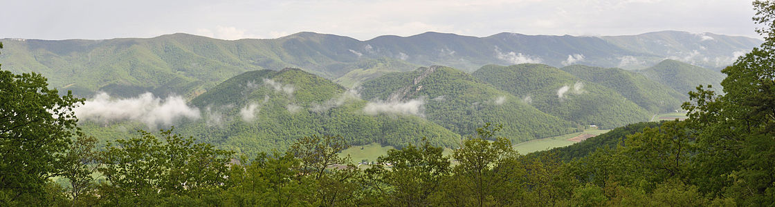
Looking south along North Fork Mountain from Nelson Sods
History
Scattered family homesteads existed on the east slope of North Fork Mountain throughout the 19th and 20th centuries. These few early settlers were of English, German or Dutch stock and constituted a community known as "Smoke Hole", named for the gorge to the east of the Mountain. None of these smallholders owned slaves, a fact that determined their Unionist sentiments during the American Civil War and brought them into sometimes violent conflict with surrounding communities during that time. Rohrbaugh Cabin (or Allegheny Cabin), a log cabin built about 1880, still stands on the eastern slope, among various related structures.[11] (It was listed on the National Register of Historic Places in 1993.[12]) The steeper western slopes have, with few exceptions, always been uninhabited. Most of the forests on the North Fork Mountain were cut for timber in the late 19th and early 20th centuries.[citation needed]
Much of North Fork Mountain has been included in the Monongahela National Forest, established in 1911. Panther Knob, near the south end of North Fork Mountain, was first explored botanically by P.A. Rydberg of the New York Botanical Garden in 1926. He was astonished by the similarity of the mountaintop to the Pine Barrens of New Jersey, especially the presence of the beach heather (Hudsonia tomentosa).[4] However, his findings were doubted until the mountaintop was revised by a group of botanists in the 1950s.[13] Botanist Paul J. Harmon studied the flora of the entire length of North Fork Mountain's ridgetop, presenting his findings in 1981.[14]
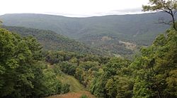
View of the eastward-looking face of the middle section of North Fork Mountain. The valley in the middle distance is Smoke Hole Canyon.
In the early 20th century, a local "character" and moonshiner – Cal Nelson – lived on the western slopes of the Mountain. "Nelson Sods" and the "Cal Nelson Trail" (former name of a portion of the North Fork Mountain Trail) are his namesakes. His colorful – sometimes outrageous – story is told in Bardon Shreve's book, A Place Called Smoke Hole.[15]
In March 1930, after an unusually mild and dry winter, an epochal forest fire ravaged North Fork Mountain consuming most of the undergrowth and smaller trees. Fire covered almost the entire Mountain and was only extinguished by rainfall after 11 days. This dramatic event motivated the Forest Service to organize a more effective program of fire suppression on the Mountain: fire wardens were hired, a 90-foot steel fire tower was built on Pike Knob,[16] and surveillance was undertaken 24 hours per day during the fire season. Over the next few years, local men were recruited, even compelled, to form quick-response, fire-fighting teams, but deep resentments were created. Many locals – "Smoke Holers" who lived on the gentler-sloping east side of the Mountain – blamed the Forest Service program for the deterioration in the quality of forage needed by their free-ranging swine and sheep and for the decline in the huckleberry patches. Locals surreptitiously started the next (and last) significant fire on the Mountain in the spring of 1941. Suppression efforts succeeded only after five days of hard work and about ten square miles of woodland were burned. The mostly unemployed local men fighting the fire happily accepted their wages though they all knew the true cause of the conflagration.[17] The foundations of the Pike Knob tower, together with the ruins of the watchman's cabin nearby, can still be seen today.[3]
Beginning in the early 1980s, The Nature Conservancy has become increasingly involved in habitat conservation on North Fork Mountain, working cooperatively with the Forest Service and with various private landowners, as well as establishing preserves on Panther Knob and on Pike Knob.[3]
Pine barrens, maintained by frequent fires, cover several peaks;[14] Panther Knob supports the largest pine barren in the Central Appalachians.[citation needed] Other rocky summits, including the 4,300-foot (1,300m) summit of Pike Knob, are blanketed by red pine (Pinus resinosa) forests,[14] here at their southernmost natural occurrences.[4][18] The Monongahela National Forest has designated 10 acres (40,000m2) of old growth red pine forest on the mountain as the North Fork Mountain Red Pine Botanical Area.[19]
The contrast is also great between North Fork Mountain's quartzite-outcrop vegetation and the superficially similar vegetation of the rocky sandstone-conglomerate openings of Spruce Knob, Dolly Sods, and similar sites just west of North Fork Mountain. While North Fork Mountain's lesser rainfall is a substantial factor in this difference, another consideration is the nature of the bedrock itself. North Fork Mountain's fine-grained Tuscarora quartzite erodes into sand, which either quickly disperses or persists in cracks and crevices, sometimes even forming tiny dunelets on wide, nearly flat open outcrops, as on Panther Knob. On the other hand, the various mountains along the Allegheny Front immediately west of North Fork Mountain are capped instead by the coarse Pottsville sandstone conglomerate, which erodes instead primarily into gravel rather than sand. While many widespread Appalachian rock-outcrop species are shared between the two areas, openings on Dolly Sods lack the silvery nailwort, the white alumroot, and table-mountain pine, and instead support a greater species diversity, even including such wetland plants as the small cranberry (Vaccinium oxycoccos).
Bristly rose (Rosa acicularis), has its southernmost known occurrence at Pike Knob on North Fork Mountain
The cliff-skirted 4,508-foot (1,374m) summit of Panther Knob supports the world's largest population of variable sedge (Carex polymorpha),[citation needed] a fire-dependent globally vulnerable plant. Beach heather (Hudsonia tomentosa),[4][14] typically found on coastal dunes, and Michaux's saxifrage (Saxifraga michauxii),[4][14] a Southern Appalachian rock-outcrop endemic, also occur there.
Fauna
A "red eft" (juvenile eastern newt) on North Fork Mountain. (Photo taken about 50 m from the Mountain's "Chimney Top" outcropping.)
North Fork Mountain and the River Knobs feature prominently in views from the mountaintops immediately west of the North Fork Valley, including Spruce Knob and Dolly Sods.
Nelson Sods on North Fork Mountain has views of the Roaring Plains, Spruce Mountain, and the North Fork Valley, as well as Shenandoah Mountain to the east. Similar views are also offered by other open summits on the mountain.
State Route 28 follows the North Fork River from North Fork Gap south to Cherry Grove, offering diverse views of the River Knobs and North Fork Mountain to the east and the Fore Knobs, Allegheny Front, and Spruce Mountain to the west.
The Germany Valley Overlook on U.S. 33, on the west side of North Fork Mountain near Judy Gap, offers views of the Germany Valley and North Fork Valley, the River Knobs and the Fore Knobs, Spruce Mountain and Spruce Knob, and the Allegheny Front extending northwards toward Dolly Sods, as well as a view back to the sandstone cliffs along the crest of North Fork Mountain itself.
Panther Knob is easily viewed from the west from Snowy Mountain Road south of Cherry Grove. Other views of Seneca Rocks and North Fork Mountain are offered by U.S. 33 as it descends the Allegheny Front approaching Seneca Rocks, and by SR 28 approaching Cherry Grove from the southwest. North Fork Gap and the eastern sides of North Fork and New Creek mountains may be seen from SR 28 west of Petersburg, with the Dolly Sods portion of the Allegheny Front visible beyond the gap.
The 23.8-mile-long North Fork Mountain Trail (NFMT) follows much of the crest of the northern portion of the mountain.[7] The trail's southern terminus is where U.S. Route 33 crosses the ridge and the northern terminus is on Smoke Hole Road, near the top of the canyon. This trail was called the best trail in West Virginia by Outside magazine.[20] Much of the southern portion of the trail crosses private property. While hiking is generally permitted, hunting and bikes are not.[21]
Variant names
North Fork Mountain is also widely referred to as North Mountain.
Photo gallery
Kile Knob from Goshen Ridge, North Fork Mountain, WV
Germany Valley, with North Fork Mountain to the east on right
↑ Manchin (U.S. Senator), Joe III (26 July 2011). Letter to Jerry Payne, Ripley, West Virginia. Washington, D.C.: Reprinted in the newsletter of the Friends of the Blackwater Canyon (September 2011 issue, page 10).
1 2 Taylor, John Craft (2006). "North Fork Mountain". West Virginia Encyclopedia, The. Charleston, West Virginia: West Virginia Humanities Council. ISBN0-9778498-0-5.
↑ "PRISM Climate Group, Oregon State University". PRISM Climate Group, Oregon State University. Retrieved 24 October 2023. To find the table data on the PRISM website, start by clicking Coordinates (under Location); copy Latitude and Longitude figures from top of table; click Zoom to location; click Precipitation, Minimum temp, Mean temp, Maximum temp; click 30-year normals, 1991-2020; click 800m; click Retrieve Time Series button.
↑ Core, Earl L. (1952). "Botanizing on Panther Knob, West Virginia". Wild Flower. 28: 35–38.
1 2 3 4 5 6 Harmon, Paul J. (1981). Ridge Top Flora of North Fork Mountain, Grant and Pendleton Counties, West Virginia (MS Thesis). Carbondale: University of Illinois.
↑ West Virginia Writer's Project (1941), West Virginia: A Guide to the Mountain State, New York: Oxford University Press, pg 347. Sponsored by the Conservation Commission of West Virginia.
This page is based on this Wikipedia article Text is available under the CC BY-SA 4.0 license; additional terms may apply. Images, videos and audio are available under their respective licenses.