
The Potomac River is a major river in the Mid-Atlantic region of the United States that flows from the Potomac Highlands in West Virginia to the Chesapeake Bay in Maryland. It is 405 miles (652 km) long, with a drainage area of 14,700 square miles (38,000 km2), and is the fourth-largest river along the East Coast of the United States and the 21st-largest in the United States. More than 5 million people live within its watershed.

The Mason–Dixon line, also called the Mason and Dixon line or Mason's and Dixon's line, is a demarcation line separating four U.S. states, forming part of the borders of Pennsylvania, Maryland, Delaware, and West Virginia. It was surveyed between 1763 and 1767 by Charles Mason and Jeremiah Dixon as part of the resolution of a border dispute involving Maryland, Pennsylvania, and Delaware in the colonial United States. The dispute had its origins almost a century earlier in the somewhat confusing proprietary grants by King Charles I to Lord Baltimore (Maryland), and by his son King Charles II to William Penn.

Hampshire County is a county in the U.S. state of West Virginia. As of the 2020 census, the population was 23,093. Its county seat is Romney, West Virginia's oldest town (1762). The county was created by the Virginia General Assembly in 1754, from parts of Frederick and Augusta Counties (Virginia) and is the state's oldest county. The county lies in both West Virginia's Eastern Panhandle and Potomac Highlands regions.

Paw Paw is a town in Morgan County, West Virginia, United States. The population was 410 at the 2020 census. The town is known for the nearby Paw Paw Tunnel. Paw Paw was incorporated by the Circuit Court of Morgan County on April 8, 1891, and named after pawpaw, a wild fruit that grows in abundance throughout this region. Paw Paw is the westernmost incorporated community in Morgan County, and the Hagerstown-Martinsburg, MD-WV Metropolitan Statistical Area.

The Northern Neck is the northernmost of three peninsulas on the western shore of the Chesapeake Bay in the Commonwealth of Virginia. The Potomac River forms the northern boundary of the peninsula; the Rappahannock River demarcates it on the south. The land between these rivers was formed into Northumberland County in 1648, prior to the creation of Westmoreland County and Lancaster County. The Northern Neck encompasses the following Virginia counties: Lancaster, Northumberland, Richmond, King George and Westmoreland; it had a total population of 50,158 as of the 2020 census.

The Allegheny Mountain Range, informally the Alleghenies, is part of the vast Appalachian Mountain Range of the Eastern United States and Canada and posed a significant barrier to land travel in less developed eras. The Allegheny Mountains have a northeast–southwest orientation, running for about 300 miles (480 km) from north-central Pennsylvania, southward through western Maryland and eastern West Virginia.

Northern Virginia, locally referred to as NOVA or NoVA, comprises several counties and independent cities in the Commonwealth of Virginia in the United States. The region radiates westward and southward from Washington, D.C. With 3,257,133 people according to 2023 Census estimates, it is the most populous region of Virginia and the Washington metropolitan area.

U.S. Route 522 is a spur route of US 22 in the states of Virginia, West Virginia, Maryland, and Pennsylvania. The U.S. Highway travels in a north-south direction, and runs 308.59 miles (496.63 km) from US 60 near Powhatan, Virginia, to its northern terminus at US 11 and US 15 near Selinsgrove, Pennsylvania. US 522 serves many small cities and towns in the Piedmont, Blue Ridge Mountains, and northern Shenandoah Valley of Virginia. The highway serves the Virginia communities of Goochland, Mineral, Culpeper, the town of Washington, and Front Royal and the independent city of Winchester. US 522 then follows the Ridge-and-Valley Appalachians north and then east through the Eastern Panhandle of West Virginia, a 2-mile-wide (3.2 km) stretch of Western Maryland, and South Central Pennsylvania to its terminus in the Susquehanna Valley. The highway serves Berkeley Springs, West Virginia; Hancock, Maryland; and the Pennsylvania communities of McConnellsburg, Mount Union, Lewistown, and Middleburg.

Thomas Fairfax, 6th Lord Fairfax of Cameron, was a Scottish peer. The only resident peer in late colonial-era America, Fairfax owned a vast territory of land in Virginia known as the Northern Neck Proprietary, which his ancestors had acquired in 1649 by a land grant from King Charles II of England. The proprietary originally spanned roughly 5 million acres, and Fairfax administered it from his wilderness estate in Greenway Court, Virginia. He owned several hundred slaves on some 30 farms and derived much of his income from their labor.
John Savage was an 18th-century surveyor of colonial Virginia. He surveyed as part of a 1736 expedition to settle a boundary dispute between Lord Fairfax and the English Privy Council concerning the extent of the vast Northern Neck land grant.
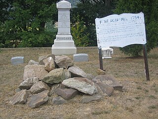
Fort Pearsall was an early frontier fort constructed in 1756 in Romney, West Virginia to protect local settlers in the South Branch Potomac River valley against Native American raids. The area around present-day Romney had been settled as early as 1725 by hunters and traders in the valley.
Thomas Lewis was an Irish-American surveyor, lawyer, politician and pioneer of early western Virginia. He was among the signers of the Fairfax Resolves, represented Augusta County at four of the five Virginia Revolutionary Conventions and the first session of the Virginia House of Delegates during the American War for Independence, and after the conflict, represented newly established Rockingham County at the Virginia Ratification Convention, as well as contributed to the settlement of an area that long after his death become part of West Virginia.

The Northern Neck Proprietary – also called the Northern Neck land grant, Fairfax Proprietary, or Fairfax Grant – was a land grant first contrived by the exiled English King Charles II in 1649 and encompassing all the lands bounded by the Potomac and Rappahannock Rivers in colonial Virginia. This constituted up to 5,000,000 acres (20,000 km2) of Virginia's Northern Neck and a vast area northwest of it.
Fairfax's Devisee v. Hunter's Lessee, 11 U.S. 603 (1813), was a United States Supreme Court case arising out of the acquisition of lands originally granted by the British King Charles II in 1649 to Lord Fairfax in the Northern Neck and westward.
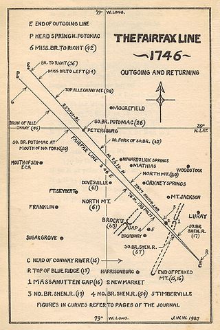
The Fairfax Line was a surveyor's line run in 1746 to establish the limits of the "Northern Neck land grant" in colonial Virginia.
The United States District Court for the District of Potomac was a short-lived United States federal court. Named for the Potomac River, it had jurisdiction over the District of Columbia and pieces of Maryland and Virginia, making it the first United States district courts to cross state lines. It was established in the Judiciary Act of 1801 – also known as the "Midnight Judges Act", because it sought to redistrict the federal courts to allow outgoing President John Adams to make additional appointments – and was abolished in the Judiciary Act of 1802. The language of the first Judiciary Act, setting forth the geographic jurisdiction of the District, was as follows:
And a new district shall be established, in the districts of Maryland and Virginia, to consist of the territory of Columbia, of all that part of the district of Maryland, which lies west and southwest of the river Patuxent, and of the western branch thereof, and south of the line which divides the county of Montgomery in the last mentioned district, from the county of Frederick, and of a line to be drawn from the termination of the last mentioned line, a northeast course to the western branch of the Patuxent; and of all that part of the district of Virginia, which lies north of the river Rappahannock, and east of the line which divides the counties of Fauquier and Loudon, in the last mentioned district from the counties of Fairfax, Prince William, and Stafford; which new district shall be called the district of Potomac, and a district court in and for the same, shall be holden at Alexandria, by the district judge of the district of Maryland, on the first Tuesday in April, and the first Tuesday in October, in each and every year.
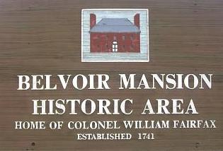
Belvoir was the plantation and estate of colonial Virginia's prominent William Fairfax family. Operated with the forced labor of enslaved people, it sat on the west bank of the Potomac River in Fairfax County, Virginia, at the present site of Fort Belvoir. The main house — called Belvoir Manor or Belvoir Mansion — burned in 1783 and was destroyed during the War of 1812. The site has been listed on the National Register of Historic Places since 1973 as "Belvoir Mansion Ruins and the Fairfax Grave."

Wappocomo is a late 18th-century Georgian mansion and farm overlooking the South Branch Potomac River north of Romney, Hampshire County, West Virginia, USA. It is located along Cumberland Road and the South Branch Valley Railroad.
Maryland v. West Virginia, 217 U.S. 1 (1910), is a 9-to-0 ruling by the United States Supreme Court which held that the boundary between the American states of Maryland and West Virginia is the south bank of the North Branch Potomac River. The decision also affirmed criteria for adjudicating boundary disputes between states, which said that decisions should be based on the specific facts of the case, applying the principles of law and equity in such a way that least disturbs private rights and title to land.
Valley was a populated place and post office on the South Branch line of the Baltimore and Ohio Railroad in the U.S. state of West Virginia. It was centered near the intersection of West Sioux Lane and Depot Valley Road, now located within the present-day corporate boundaries of Romney. Valley developed in 1884 following the completion of the South Branch line when the rail line's original southern terminus and corresponding Romney Depot were built there. The United States Post Office Department established a post office at Valley on May 19, 1928, remaining in operation until its disestablishment on June 15, 1937. Following the closure of Valley's post office, its mail was routed through the post office in Romney.


