Cheat Lake is a census-designated place in Monongalia County, West Virginia, United States, surrounding the Cheat Lake reservoir. The population was 9,930 at the 2020 census. It is included in the Morgantown metropolitan area.

Burr Oak State Park is a public recreation area located four miles (6.4 km) northeast of Glouster in the U.S. state of Ohio. The park sits mostly in Morgan County, with part extending into Athens County.

The Cumberland Gap National Historical Park is a United States National Historical Park located at the border between Kentucky, Tennessee, and Virginia, centered on the Cumberland Gap, a natural break in the Appalachian Mountains.

The Cheat River is a 78.3-mile-long (126.0 km) tributary of the Monongahela River in eastern West Virginia and southwestern Pennsylvania in the United States. Via the Ohio River, the Cheat and Monongahela are part of the Mississippi River watershed. Owing to the ruggedness of the surrounding Allegheny Mountains, the Cheat remains largely remote with few settlements or developments along its banks. Its headwaters are in the Cheat-Potomac Ranger District of the Monongahela National Forest.

Hueston Woods State Park is a state park located in Butler and Preble counties of the U.S. state of Ohio, about five miles (8 km) northeast of Oxford in the southwestern part of the state. The park lies in Oxford Township, Butler County, and Israel Township, Preble County. It has nearly 3,000 acres (1,200 ha), including a man-made lake of 625 acres (253 ha). The park's beech-maple climax forest has been designated a National Natural Landmark.
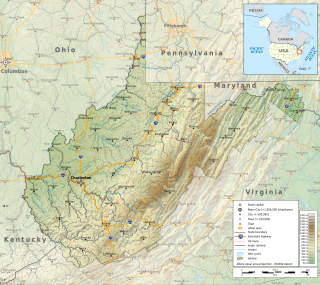
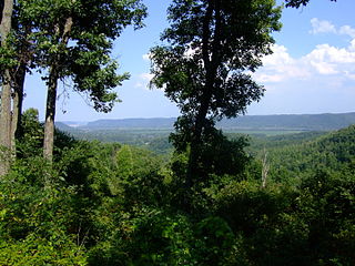
The Environment of West Virginia encompasses terrain and ecosystems ranging from plateaus to mountains. Most of West Virginia lies within the Appalachian mixed mesophytic forests ecoregion, while the higher elevations along the eastern border and in the panhandle lie within the Appalachian-Blue Ridge forests.
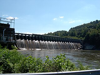
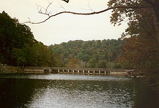
Cheat Lake is a 13-mile-long (21 km) reservoir on the Cheat River in Monongalia County, West Virginia, United States. It was originally named Lake Lynn, but the Board on Geographic Names officially decided upon Cheat Lake as the reservoir's name in 1976. Cheat Lake is located immediately downstream of the 10-mile-long (16 km) Cheat Canyon.

Blackwater Falls State Park is located in the Allegheny Mountains of Tucker County, West Virginia, US. The centerpiece of the park is Blackwater Falls, a 62-foot (19 m) cascade where the Blackwater River leaves its leisurely course in Canaan Valley and enters rugged Blackwater Canyon. It is among the most photographed venues in the state and appears on calendars, stationery, and advertisements. The river is named for its tannin-darkened water.
Trough Creek State Park is a 554 acres (224 ha) Pennsylvania state park in Cass, Penn and Todd Townships, Huntingdon County, Pennsylvania in the United States. The majority of the park is in Todd Township along Pennsylvania Route 994, east of the unincorporated village of Entriken. Huntingdon is the nearest borough. The park borders Rothrock State Forest and Raystown Lake National Recreation Area. There is a growing population of bald eagles at the lake. Fourteen eagles were spotted in January 2007. This is up from two that were spotted in 1990, the first year that an eagle survey was taken. These three sections of state and federal owned property combine together to provide hunting, hiking and fishing opportunities for the outdoorsman.

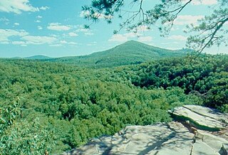
Coopers Rock State Forest is a 12,747-acre (52 km2) state forest in Monongalia and Preston counties in the U.S. state of West Virginia. Its southern edge abuts Cheat Lake and the canyon section of Cheat River, a popular whitewater rafting river in the eastern United States.

Mt. Pisgah State Park is a 1,302-acre (527 ha) Pennsylvania state park in Smithfield, Springfield, Troy and West Burlington Townships, Bradford County, Pennsylvania in the United States. The park is located almost exactly halfway between Troy and Towanda, along Pennsylvania State Route 3019, near U.S. Route 6, at the base of Mt. Pisgah. The park is bordered by Mill Creek, Mt. Pisgah County Park and State Game Land 289. Mill Creek which flows through the park has been dammed and forms Stephen Foster Lake a 75-acre (30 ha) man-made lake.
Standing Stone State Park is a state park in Overton County, Tennessee, in the southeastern United States. The park consists of 855 acres (3.46 km2) along the shoreline of the man-made 69-acre (0.28 km2) Standing Stone Lake. The 11,000-acre (45 km2) Standing Stone State Forest surrounds the park.
Shawnee State Park is a 1,095-acre (443 ha) public recreation area surrounded by the 63,000-acre (25,000 ha) Shawnee State Forest in Scioto County, Ohio, United States. The park is in the foothills of the Appalachian Mountains near the Ohio River in Southern Ohio on State Route 125, just north of Friendship.

Lake Hope State Park is a public recreation area encompassing 2,983 acres (1,207 ha) within Zaleski State Forest, located five miles (8.0 km) northeast of Zaleski in Vinton County, Ohio. The state park is centered on Lake Hope, a 120-acre (49 ha) impoundment on Big Sandy Run.
Ganoga Lake is a natural lake in Colley Township in southeastern Sullivan County in Pennsylvania, United States. Known as Robinson's Lake and Long Pond for most of the 19th century, the lake was purchased by the Ricketts family in the early 1850s and became part of R. Bruce Ricketts' extensive holdings in the area after the American Civil War. The lake is one of the highest in Pennsylvania, which led Ricketts to name it Highland Lake by 1874 and rename it Ganoga Lake in 1881; Pennsylvania senator Charles R. Buckalew suggested the name Ganoga from the Seneca language word for "water on the mountain".
Hopemead State Park is an undeveloped public recreation area on the eastern shore of Gardner Lake, 8 miles (13 km) west of Norwich, Connecticut. The state park covers 60 acres (24 ha) in the towns of Bozrah and Montville and is managed by the Connecticut Department of Energy and Environmental Protection.

Lacey-Keosauqua State Park is located southwest of Keosauqua, Iowa, United States. The park is located along the Des Moines River in Van Buren County. First dedicated in 1921, it is the largest state park in size in Iowa. In 1990, three areas were named nationally recognized historic districts and listed on the National Register of Historic Places.

Booker T. Washington State Park is a former state park near the community of Institute in the U.S. state of West Virginia. The park was operated by the West Virginia Conservation Commission, Division of State Parks, from 1949 until the late 1950s.