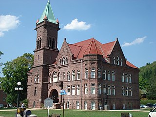
Barbour County is a county in north-central West Virginia, US. At the 2020 census, the population was 15,465. The county seat is Philippi, which was chartered in 1844. Both county and city were named for Philip P. Barbour (1783–1841), a U.S. Congressman from Virginia and Associate Justice of the U.S. Supreme Court. The county was formed in 1843 when the region was still part of the state of Virginia. In 1871, a small part of Barbour County was transferred to Tucker County, West Virginia.

Belington is a town in Barbour County, West Virginia, United States, situated along the Tygart Valley River. The population was 1,921 as of the 2010 census.

The Monongahela River —often referred to locally as the Mon —is a 130-mile-long (210 km) river on the Allegheny Plateau in north-central West Virginia and southwestern Pennsylvania. The river flows from the confluence of its west and east forks in north-central West Virginia northeasterly into southwestern Pennsylvania, then northerly to Pittsburgh and its confluence with the Allegheny River to form the Ohio River. The river's entire length is navigable via a series of locks and dams.
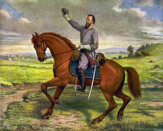
Jackson's Valley campaign, also known as the Shenandoah Valley campaign of 1862, was Confederate Maj. Gen. Thomas J. "Stonewall" Jackson's spring 1862 campaign through the Shenandoah Valley in Virginia during the American Civil War. Employing audacity and rapid, unpredictable movements on interior lines, Jackson's 17,000 men marched 646 miles (1,040 km) in 48 days and won several minor battles as they successfully engaged three Union armies, preventing them from reinforcing the Union offensive against Richmond.

The Allegheny Mountain Range, informally the Alleghenies, is part of the vast Appalachian Mountain Range of the Eastern United States and Canada and posed a significant barrier to land travel in less developed eras. The Allegheny Mountains have a northeast–southwest orientation, running for about 400 miles (640 km) from north-central Pennsylvania, southward through western Maryland and eastern West Virginia.

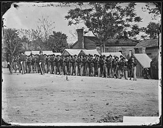
The Battle of Philippi formed part of the Western Virginia Campaign of the American Civil War and was fought in and around Philippi, Virginia, on June 3, 1861. A Union victory, it was the first organized land action of the war, though generally viewed as a skirmish rather than a battle. However, the Northern press celebrated it as an epic triumph and this encouraged Congress to call for the drive on Richmond that ended with the Union defeat at First Bull Run in July. It brought overnight fame to Maj. Gen. George B. McClellan and was notable for the first battlefield amputations. As the first of a series of victories that pushed Confederate forces out of northwest Virginia, it strengthened the Union government in exile that would soon create the new state of West Virginia.
The Battle of Greenbrier River, also known as the Battle of Camp Bartow, took place on October 3, 1861 in Pocahontas County, Virginia as part of the Operations in Western Virginia Campaign during the American Civil War.

The First Battle of Kernstown was fought on March 23, 1862, in Frederick County and Winchester, Virginia, the opening battle of Confederate Maj. Gen. Thomas J. "Stonewall" Jackson's campaign through the Shenandoah Valley during the American Civil War.
The Stonewall Brigade of the Confederate Army during the American Civil War, was a famous combat unit in United States military history. It was trained and first led by General Thomas J. "Stonewall" Jackson, a professor from Virginia Military Institute (VMI). His severe training program and ascetic standards of military discipline turned enthusiastic but raw recruits into an effective military organization, which distinguished itself from the First Battle of Bull Run in 1861 to Spotsylvania Court House in 1864. Its legacy lives on in the 116th Infantry Brigade, which bears the unofficial nickname "Stonewall Brigade," and in several living history reenactment groups.

The Tygart Valley River — also known as the Tygart River — is a principal tributary of the Monongahela River, approximately 135 miles (217 km) long, in east-central West Virginia in the United States. Via the Monongahela and Ohio rivers, it is part of the watershed of the Mississippi River, draining an area of 1,329 square miles (3,440 km2) in the Allegheny Mountains and the unglaciated portion of the Allegheny Plateau.

Shavers Fork Mountain Complex is the name given to the mountains on either side of Shavers Fork in the highlands portions of Randolph County, Pocahontas County, and Tucker County in West Virginia, USA. Much of the land surrounding the river and its adjacent mountains is protected by Monongahela National Forest including about 20,000 acres (81 km2) of designated wilderness.

Cheat Mountain is an exceptionally high and rugged ridge situated in the Allegheny Mountains of eastern West Virginia, USA. It is about 50 miles (80 km) long and more than five miles (8 km) wide at its widest. Its highest point is at its southernmost end at Thorny Flat, which has an elevation of 4,848 feet (1,478 m). Several other knobs rise above 4,000 feet (1,200 m) along its length.

The U.S. state of West Virginia was formed out of western Virginia and added to the Union as a direct result of the American Civil War, in which it became the only modern state to have declared its independence from the Confederacy. In the summer of 1861, Union troops, which included a number of newly-formed Western Virginia regiments, under General George McClellan, drove off Confederate troops under General Robert E. Lee. This essentially freed Unionists in the northwestern counties of Virginia to form a functioning government of their own as a result of the Wheeling Convention. Prior to the admission of West Virginia the government in Wheeling formally claimed jurisdiction over all of Virginia, although from its creation it was firmly committed to the formation of a separate state.
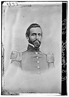
Robert Selden Garnett was a career military officer, serving in the United States Army until the American Civil War, when he became a Confederate States Army brigadier general. He was the first general officer killed in the Civil War.
The Staunton-Parkersburg Turnpike was built in what is now the U.S. states of Virginia and West Virginia during the second quarter of the 19th century to provide a roadway from Staunton, Virginia and the upper Shenandoah Valley to the Ohio River at present-day Parkersburg, West Virginia. Engineered by Claudius Crozet through the mountainous terrain, it was a toll road partially funded by the Virginia Board of Public Works. Control of this road became crucial during the American Civil War. Today, the Staunton-Parkersburg Turnpike can be largely traversed by following West Virginia Route 47 east from Parkersburg to Linn, then U.S. Route 33 east through Weston and Buckhannon to Elkins, then U.S. Route 250 southeast through Beverly, Huttonsville, crossing the West Virginia/Virginia state line to Staunton, Virginia.
The 9th Indiana Volunteer Infantry Regiment was a volunteer infantry regiment in the Union Army during the American Civil War. It was organized on April 22, 1861, for three-months' service in Indianapolis. After being reorganized for three years' service in late August and early September 1861, the 9th took part in many major battles, including Shiloh, Stones River, Chickamauga, Lookout Mountain, Missionary Ridge, Kennesaw Mountain and the Siege of Atlanta.
The Shawnee Trail was the white settlers' name for an American Indian trail in what is now eastern West Virginia, USA. It was a segment of the much larger Indian trail network known as the Great Indian Warpath, which stretched from New York to Alabama. The GIW was referred to from this point north as the "Seneca Trail". Thus, in pioneer days, the segment known as the Shawnee Trail was often also referred to as the Seneca Trail.
The western Virginia campaign, also known as operations in western Virginia or the Rich Mountain campaign, occurred from May to December 1861 during the American Civil War. Union forces under Major General George B. McClellan invaded the western portion of Virginia to prevent Confederate occupation; this area later became the state of West Virginia. West Virginians on both sides would fight in the campaign while a Unionist convention in Wheeling would appoint their choice for a Unionist governor for Virginia, Francis H. Pierpont, and promote the creation of a new state in western Virginia. Large scale Confederate forces would gradually abandon the region, leaving it to small local brigades to maintain hold on southern and eastern sections for much of the war.
The North Western Virginia Railroad was chartered by the Virginia General Assembly as the Northwestern Virginia Railroad on February 14, 1851 in order to build track from Grafton, West Virginia to Parkersburg, West Virginia. Future statehood advocate and U.S. Senator Peter G. Van Winkle of Parkersburg began as the Northwestern Railroad's secretary in 1852 and served as its President through the American Civil War.
