
Mirzapur division, also sometimes known as Vindhyachal division, is one of the 18 administrative geographical units of the northern Indian state of Uttar Pradesh. Mirzapur city is the administrative headquarters. As of 2018, the division consists of 3 districts:-

Bhadohi district is a district of Uttar Pradesh state in northern India. It is also referred to as Sant Ravidas Nagar. It is the smallest district by area in the state of Uttar Pradesh which was created on June 30, 1994 by dividing western part of the district Varanasi. It is surrounded by Varanasi district on east, Allahabad on west, Jaunpur north and Mirzapur district in south. The state capital Lucknow is distanced at 234 KM from Bhadohi. Its district headquarters is situated in the city of Gyanpur. The district is popularly known for carpet weaving as it is one of largest centres of Carpet Industries in India and therefore it also known as the 'Carpet City of India'. Carpets of Bhadohi have 'Geographical Indication' tag attached to it. Bhadohi has huge geographical significance and position attached to it due to its location between two culturally important and rich heritage cities of Prayagraj and Varanasi.
Surajpur is a Nagar Palika Parishad situated in the bank of Rihand River in Surajpur district of Chhattisgarh state in Central India. It is the administrative headquarters of the Surajpur district, located 334 km away from the state's capital city, Raipur. National Highway 43 passes through Surajpur.

Ailum, is Nagar panchayat town in Shamli district in the Indian state of Uttar Pradesh, situated in the upper doab region of River Ganga and Yamuna. It is located at a distance of 75 km from National Capital New Delhi and a part of the National Capital Region (NCR) of India.
Dibiyapur is a municipality-based city in Auraiya district in the most populous state of Uttar Pradesh in India. It is situated on State Highway 21. It is linked to Phaphund railway station on Kanpur–Delhi section of Howrah–Delhi main line and Howrah–Gaya–Delhi line which is operated by North Central Railway. The district administrative headquarter of the city is Auraiya. The city is situated between Agra and Kanpur. Lower Ganga Canal passes through mid of the city.
Pharenda, or Anandnagar, is a city in the Maharajganj district of the province of Uttar Pradesh in northern India. It is located approximately 44 kilometres north of Gorakhpur near the border with Nepal. District of Pharenda is Maharajganj. This is situated on the Buddhist Circuit which is built from Sarnath to Lumbini. It lies on NH-24 and near NH 29. It is about 45 km from Gorakhpur, 40 km from Siddharthnagar, 30 km from Maharajganj and 55 km from Sonauli Indo-Nepal border. This place is named after Seth Anandram Jaypuriya. There is closed sugar Mill which was started in about 1935 and closed in 1995. Near Anand Nagar there is a temple is Durga devi mandir, popularly known as Lehara Devi mandir.

Ghughuli is a town and nagar panchayat in Maharajganj district in the Indian state of Uttar Pradesh. It is near Gorakhpur and very close to the Indo-Nepal border. East of Ghughali is the Baikunthi River. The bank of the Baikunthi is used for performing last rites and the quarry is for river sand.
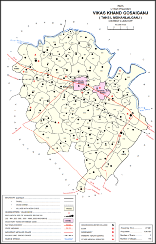
Gosainganj, also spelled Goshainganj or Gosaiganj is a town and nagar panchayat in Lucknow district of Uttar Pradesh, India. It is the seat of a community development block, which is included in the tehsil of Mohanlalganj. As of 2011, its population is 9,649, in 1,685 households. The starting point of the Purvanchal Expressway i.e. Chand Saray village is situated 2.5 km away from Gosainganj.
Kopaganj is a town and a nagar panchayat in Mau district in the Indian state of Uttar Pradesh.
Nichlaul is a town and a nagar panchayat in Maharajganj district in the Indian state of Uttar Pradesh. It is situated 25 km from district headquarter Maharajganj and 80 km from Gorakhpur. It is situated near the Indo-Nepal border.
Parikshitgarh is a town and a Nagar Panchayat in Meerut district in the Indian state of Uttar Pradesh.
Pipri is a town and a nagar panchayat in Sonbhadra district in the Indian state of Uttar Pradesh.

Renukoot is a town and a nagar panchayat in Sonbhadra district in the Indian state of Uttar Pradesh. It is 68 km south from the district headquarters Robertsganj.
Reoti is a town and a nagar panchayat in Ballia district in the Indian state of Uttar Pradesh. Known for got freedom before 1947 As usual India had got freedom on 15 Aug 1947 but all across the India Reoti town got freedom in 1942.
Rura is a Nagar Panchayat in Kanpur Dehat District in Uttar Pradesh state of the India. The town is situated on the banks of Lower Ganga canal. The district headquarters is 15 km away at Mati. The town is located at a distance of 49 km from famous industrial and educational hub of Kanpur Nagar.
Saurikh is a nagar panchayat in Kannauj district in the Indian state of Uttar Pradesh. Its old name was Sau-Rishi.It is located near main industrial and educational hub of Dibiyapur which is around at a distance of 55 km from the town.
Rihand Nagar is a township, named after the Rihand River, a tributary of the Sone River. It is located near Bijpur and lies in the Sonebhadra district of Uttar Pradesh. This township is situated near the border of Uttar Pradesh and Madhya Pradesh in India. This township has been developed by National Thermal Power Corporation (NTPC) under its Power Project Scheme, wherein it established a coal-based power station of 3000 MW capacity.
Belthara Road is a Nagar Panchayat city with a railway station in the north-western corner of Ballia district of Uttar Pradesh, India.

Surajpur district is a district in the state of Chhattisgarh in central India, with its administrative headquarters at Surajpur. National Highway 43 passes through Surajpur district. Surajpur was declared a district on 15 August 2011 along with eight other new districts. Surajpur is the first district to receive National Satyan Maitra Literacy Award. The district is known for its market and other major tourist places of Chhattisgarh with Tamor Pingla Wildlife Sanctuary.
Fatehpur Gayand is a village situated in Shahabad sub district of District Hardoi, Uttar Pradesh. Population of the village is lump som 8000. Fatehpur Gayand is a Gram Panchayat and Nyay Panchayat under Todarpur Block of District Hardoi.
