Sone River, also spelt Son River, is a perennial river located in central India. It originates near Amarkantak Hill in Pendra, Chhattisgarh and finally merges with the Ganga river near Maner in Patna, Bihar. The Sone River is the second-largest southern tributary of the Ganges after the Yamuna River. India's oldest river bridge Koilwar Bridge over Sone River connects Arrah with Patna. Sone river is famous for its sand across country. Multiple dam(s) and hydro-electric projects run on its course towards Ganges.
Sonbhadra or Sonanchal is the second largest district by area of Uttar Pradesh after Lakhimpur Kheri. The district headquarters is in the town of Robertsganj. Sonbhadra is also known as the "Energy Capital of India" because there are multiple power plants.
Garhwa is a town and a municipality in, and headquarters of, Garhwa district in the state of Jharkhand, India. Uttar Pradesh, Chhattisgarh and Bihar are nearby states. Garhwa Road (Rehla) is a major Railway Junction where thousands of passengers find this station most convenient to catch their train for Delhi and Kolkata. Bus services are available for Ranchi, Ambikapur, Gaya, etc.

Hindalco Industries Limited an Indian aluminium and copper manufacturing company, is a subsidiary of the Aditya Birla Group. Its headquarters are at Mumbai, Maharashtra, India.

The Rihand River is a tributary of the Son River and flows through the Indian states of Chhattisgarh, Madhya Pradesh and Uttar Pradesh. Its old name was Renu or Renuka.

Mirzapur division, also sometimes known as Vindhyachal division, is one of the 18 administrative geographical units of the northern Indian state of Uttar Pradesh. Mirzapur city is the administrative headquarters. Currently, the division consists of 3 districts:-

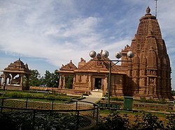
Mirzapur district is one of the 75 districts in the Indian state of Uttar Pradesh. The district is bounded on the north by Bhadohi and Varanasi districts, on the east by Chandauli district, on the south by Sonbhadra district and on the northwest by Prayagraj. The district occupies an area of 4521 km2. Mirzapur city is the district headquarters. Mirzapur district is a part of Mirzapur division. This district is known for the Vindhyavasini temple in Vindhyachal and several tourist attractions like water falls like Rajdari & Devdari and dams. It consist of several Ghats where historical sculptures are still present. During the Ganges festival these Ghats are decorated with lights and diyas.

Surajpur is a Nagar Palika Parishad situated in the bank of Rihand River in Surajpur district of Chhattisgarh state in Central India. It is the administrative headquarters of the Surajpur district, located 334 km away from the state's capital city, Raipur. National Highway 43 passes through Surajpur.

Robertsganj also known as Sonbhadra City is a city and a municipal board in Sonbhadra district in the Indian state of Uttar Pradesh.
Dudhi or Duddhi is a town and & Nagar panchayat in Sonbhadra district in the state of Uttar Pradesh, India. It belongs to Mirzapur Division. It is located 64 km south of the district capital, Robertsganj. Dudhi is a tehsil of sonebhadra district. Renukoot, Anpara, Obra, Robertsganj are the nearby Cities to Dudhi. Dudhinagar-Renukoot is demanded district by dudhinagar people. There are many places to visit and enjoy natural beauty and environment of this town. This has hidden tourism site as locals have named one site as "Mini Goa" people visit this place to celebrate New year.
Obra is a town, Tehsil, and Assembly constituency of the Indian state of Uttar Pradesh. It is located in the Sonebhadra district. It has been upgraded from the stature of Nagar Panchayat, and was previously a part of the Mirzapur District. Obra is located 137 km from Varanasi at the Banks of Renu & Sone River with population of 46,574 as per the 2011 India Census. State-owned UPRVUNL and UPJVUNL have a coal-fired thermal power plant and a hydroelectric power plant in Obra, respectively. The thermal and hydroelectric power industries are the major source of employment, either directly or indirectly. Obra is not very well connected by rail. The nearest railway station is Chopan, which is about 10 kilometers from Obra, and has connectivity to other major cities of India. Recreational places in Obra include Jawahar Bal Udayan, Ambedkar Stadium, Lord Shiva's temple, Sone river banks, and Parsoi and Kharatiya villages. Restructuring of government residential colony is ongoing as new power plants are being constructed.
Pipri is a town and a nagar panchayat in Sonbhadra district in the Indian state of Uttar Pradesh.
Renusagar is a town situated in the south of Sonbhadra, Uttar Pradesh, India. Renusagar is the home of Renusagar Power Plant, a 700 MW captive power plant which supplies electricity to Hindalco Industries' operations in Renukoot. The rest of the town is mostly a middle class residential community, managed by the Civic Authority of Hindalco.

Singrauli district is one of the districts in the Indian state of Madhya Pradesh.
Shaktinagar is a small town in Sonbhadra, Mirzapur Division, Uttar Pradesh near Varanasi, India. The city borders with Madhya Pradesh at Jayant Border.
Rihand Dam also known as Govind Ballabh Pant Sagar, is the second largest dam of India by volume (storage) next only to Indirasagar Dam of Madhya Pradesh. The reservoir of Rihand Dam is called Govind Ballabh Pant Sagar and is India's largest artificial lake. Rihand Dam is a concrete gravity dam located at Pipri in Sonbhadra District in Uttar Pradesh, India. Its reservoir area is on the border of Madhya Pradesh and Uttar Pradesh. It is located on the Rihand River, a tributary of the Son River. The catchment area of this dam extends over Uttar Pradesh, Madhya Pradesh & Chhattisgarh whereas it supplies irrigation water in Bihar located downstream of the river.
Rihand Nagar is a township, named after the Rihand River, a tributary of the Sone River. It is located near Bijpur and lies in the Sonebhadra district of Uttar Pradesh. This township is situated near the border of Uttar Pradesh and Madhya Pradesh in India. This township has been developed by National Thermal Power Corporation (NTPC) under its Power Project Scheme, wherein it established a coal-based power station of 3000 MW capacity.

Rihand Super Thermal Power Project is located at Renukut, Sonebhadra in Sonbhadra district in Indian state of Uttar Pradesh. The power plant is one of the coal based power plants of NTPC Limited.
Shree Banshidhar Nagar, also known as Nagar Unntari, is one of the administrative block in Garhwa district, Jharkhand state, India. It is located 40 km towards west from District headquarters Garhwa in Bhawanathpur Bidhansabha. Shree Banshidhar Nagar is surrounded by states Uttar Pradesh, Chhattisgarh and Bihar.
Bagru is a village in the Kisko CD block in the Lohardaga Sadar subdivision of the Lohardaga district in the Indian state of Jharkhand.