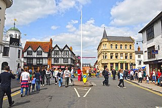
Stratford-upon-Avon, commonly known as just Stratford, is a market town and civil parish in the Stratford-on-Avon district, in the county of Warwickshire, in the West Midlands region of England. It is situated on the River Avon, 91 miles (146 km) north-west of London, 22 miles (35 km) south-east of Birmingham and 8 miles (13 km) south-west of Warwick. The town is the southernmost point of the Arden area on the edge of the Cotswolds. In the 2021 census Stratford had a population of 30,495.

Stratford-on-Avon is a local government district in Warwickshire, England. The district is named after its largest town of Stratford-upon-Avon, but with a change of preposition; the town uses "upon" and the district uses "on". The council is based in Stratford-upon-Avon and the district, which is predominantly rural, also includes the towns of Alcester, Shipston-on-Stour and Southam, and the large villages of Bidford-on-Avon, Studley and Wellesbourne, plus numerous other smaller villages and hamlets and surrounding rural areas. The district covers the more sparsely populated southern part of Warwickshire, and contains nearly half the county's area. The district includes part of the Cotswolds, a designated Area of Outstanding Natural Beauty.

The Forest of Arden is a former forest and culturally defined area located in the English West Midlands, that in antiquity and into the Early Modern Period included much of Warwickshire, and parts of Shropshire, Staffordshire, the West Midlands, and Worcestershire. It is associated with William Shakespeare as a territory of his youth, and the setting of some of his drama.

The Collegiate Church of the Holy and Undivided Trinity, Stratford-upon-Avon, is a Grade I listed parish church of the Church of England in Stratford-upon-Avon, Warwickshire, England. It is often known simply as Holy Trinity Church or as Shakespeare's Church, due to its fame as the place of baptism, marriage and burial of William Shakespeare. More than 200,000 tourists visit the church each year.
Swalcliffe is a village and civil parish about 5 miles (8 km) west of Banbury in Oxfordshire. The parish is about 2+1⁄2 miles (4 km) long north–south and about 1 mile (1.6 km) east–west. The 2011 Census recorded the population of the modern Swalcliffe parish as 210. The toponym "Swalcliffe" comes from the Old English swealwe and clif, meaning a slope or cliff frequented by swallows. The ancient parish of Swalcliffe was larger than the present civil parish, and included the townships of East Shutford, Epwell, Sibford Ferris, Sibford Gower and West Shutford.

Wilmcote is a village, and since 2004 a separate civil parish, in the English county of Warwickshire, about 3 miles (5 km) north of Stratford-upon-Avon. Prior to 2004, it was part of the same parish as Aston Cantlow, and the 2001 population for the whole area was 1,670, reducing to 1,229 at the 2011 Census.

Temple Grafton is a village and civil parish in the Stratford-on-Avon district of Warwickshire, England, situated about 4 miles (6.4 km) east of Alcester and 14 miles (23 km) west of the county town of Warwick. The place name is misleading, the Knights Templar never having any association with the place but owing to a naming error made in the time of Henry VIII the mistake has been perpetuated. During the reign of Richard I the estate in fact belonged to the Knights Hospitaller. During the reign of Edward III in 1347 the village was recorded as Grafton Superior while neighbouring Ardens Grafton was named Inferior.
Detmar Jellings Blow was a British architect of the early 20th century, who designed principally in the arts and crafts style. His clients belonged chiefly to the British aristocracy, and later he became estates manager to the Duke of Westminster.
Rowington is a village and civil parish in the English county of Warwickshire. It is five miles north-west of the town of Warwick and five miles south-west of the town of Kenilworth. The parish, which also includes Lowsonford, Pinley and Mousley End, had a population of 925 according to the 2001 UK Census, increasing to 944 at the 2011 Census. The Grand Union Canal runs just south of the village and the M40 motorway is also close by. The Heart of England Way for long-distance walkers passes through the village. The parish church of St. Laurence which dates from medieval times is found on a hill in the centre of the village. In the Tudor era Rowington manor was owned by Queen Catherine Parr.
Luddington is a small village and civil parish in the English county of Warwickshire and is part of Stratford-on-Avon district. The community is a conservation area due to its historic aspects. In 2001, the population was 457, increasing to 515 at the 2021 Census. It is located about 5 kilometres outside the town of Stratford-upon-Avon on the banks of the river Avon and has views south over the Cotswolds. Facilities and communications include a phone box, a 19th-century church, a post box, a marina with a 17th-century lock, a village green and a recently refurbished village hall originally built in 1953. The parish encompasses Dodwell Caravan Park to the north of the village. The village is reputed to be the meeting place of Anne Hathaway and William Shakespeare, as Anne was from the parish, and local lore states that they probably conducted their courtship in the area.

Long Marston is a village and civil parish about 5 miles (8 km) southwest of Stratford-upon-Avon in Warwickshire, England. The southern and western boundaries of the parish form part of the county boundary with Worcestershire. The 2011 census recorded the parish's population as 436.

Ettington is a village and civil parish about 5.5 miles (9 km) south-east of Stratford-upon-Avon in Warwickshire, England. The 2011 Census recorded the parish's population as 1,171. The present village is on the A422 main road linking Stratford and Banbury. The A429 main road linking Warwick and Cirencester used to run through the village, and now uses a bypass just west of it. The Fosse Way Roman road crosses the A422 0.6 miles (1 km) east of the village.

Great Wolford is a village and civil parish in the Stratford-on-Avon district of Warwickshire, England. With the neighbouring parish of Little Wolford it is part of 'The Wolfords'.

Ratley is a village in the civil parish of Ratley and Upton, Stratford-on-Avon District, Warwickshire, England. The population of the civil parish in 2011 was 327. It is on the northwest side of the Edge Hill escarpment about 200 metres (660 ft) above sea level. The village is close to the county border with north Oxfordshire, some 7 miles northwest of Banbury, the closest town.

Stretton-on-Fosse is a village in the Stratford District in Warwickshire, England. It is situated between the towns of Moreton-in-Marsh and Shipston-on-Stour. The village is situated along the ancient Fosse Way road which runs from Exeter in Devon to Lincoln in Lincolnshire. The road bypasses the village to the east and is now the modern-day A429 road. The village is close to the Gloucestershire and Warwickshire border. While the lower ground of the village is heavy clay the upper parts are composed of sand and shingle. During commercial extraction of sand important graves of the Roman-British and Anglo-Saxon periods were uncovered and interesting skeletons and personal belongings were unearthed. These burials were the result of internecine warfare between local tribal factions.

Exhall is a village and civil parish about 1+1⁄4 miles (2 km) south-south-east of Alcester in the Stratford-on-Avon district of Warwickshire, England. Its parish includes the hamlet of Little Britain and part of Ardens Grafton, the greater part of which is in the neighbouring civil parish of Temple Grafton. The 2011 Census recorded Exhall parish's population as 203. Exhall is on Hay Brook, a tributary of the River Arrow. The civil parish neighbours those of Alcester and Wixford, with which it shares both an ecclesiastical parish and a cricket club.

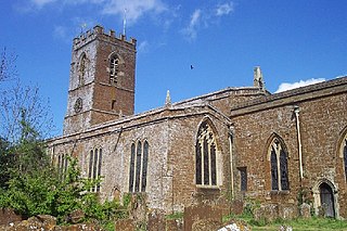
All Saints Church is a redundant Anglican church in the village of Billesley, Warwickshire, England. It is recorded in the National Heritage List for England as a designated Grade I listed building, and is under the care of the Churches Conservation Trust.

Seckington is a village and civil parish in North Warwickshire, about 4 miles (6 km) northeast of Tamworth. The B4593 road between Tamworth and Appleby Magna runs through the parish, passing about 100 yards (91 m) north of the village. Seckington shares a parish council with Newton Regis and No Man's Heath. Forming part of the border with Staffordshire, it is the second most northerly settlement in Warwickshire, with only No Man's Heath situated further north, and is only 3.5 miles due south of the Derbyshire border.

Tidmington is a village and civil parish in the Stratford-on-Avon District of Warwickshire, England. It is 11 miles (18 km) south from the town of Stratford-upon-Avon, and at the extreme southern edge of the county bordering Gloucestershire. Within the parish is the Grade II* listed c.1600 Tidmington House, and the Grade II* early 13th-century church of unknown dedication. At the 2001 Census, which for statistical purposes now includes the neighbouring parish of Burmington, the combined population was 153.
Little Wolford is a hamlet and civil parish in the Stratford-on-Avon district of Warwickshire, England. With the neighbouring parish of Great Wolford it is part of 'The Wolfords'. Little Wolford is significant for its Grade II* listed 15th- to 16th-century Little Wolford Manor.
