Bina-Etawa

Last updated

Bina-Etawa
Railway junction, petroleum refinery and JP power plant city of Madhya Pradesh, India[ citation needed ]
Bina-etawahfromtop.jpg
A night view of Bina
Nickname: 
इटावा/बीना
Madhya Pradesh location map.svg
Red pog.svg
Bina-Etawa
Location in Madhya Pradesh, India
Coordinates: 24°10′48″N78°12′0″E / 24.18000°N 78.20000°E / 24.18000; 78.20000
CountryFlag of India.svg  India
State Madhya Pradesh
Division Sagar Division
District Bina-etawa District
Government
  BodyNagar Palika Parishad Bina-Etawa
Area
  Total64 km2 (25 sq mi)
  Rank41
Elevation
412 m (1,352 ft)
Population
 (2024)
  Total402,678 [1]
  Density5,377/km2 (13,930/sq mi)
Demonym Beena-Itawa
Languages
  Official
Time zone UTC+5:30 (IST)
PIN
470113,470118, 470124, 464240
Vehicle registration MP-15,MP-08 , MP-40

Bina-Etawa, shortened to Bina, is a city in the Bina-etawa district of the Indian state of Madhya Pradesh. The city's name is derived from the Bina River that flows near the city.

Contents

Bina is the fastest growing city in Madhya Pradesh. It is a center of economic and industrial activity in the state. Bina Refinery is there, as well as Jaypee Group's 500  MW Jaypee Bina thermal plant. [2] This region is known for its high-quality wheat, which is exported internationally. [3]

Geography

Five rivers flow through the surrounding area. In addition to Bina River, they include:

Bina is close to the ancient city of Eran. Eran was the capital of Airikina Pradesha, an administrative division of the Gupta Empire. Bina sits between Bhopal and Jhansi, Uttar Pradesh. It is among the oldest cities in the region and the oldest in the state.

The Bina and Betwa Rivers are the major water sources. [4]

History

Bina was formerly known as Etawa, the name of an earlier village in the area. In 1923, the Bina Railway Junction was established, deriving it name from the river. The first Member of the Legislative Assembly of the Bina Assembly constituency was Ram Lal Nayak, elected in 1957. The name Bina-Etawa was unofficially used to remove any ambiguity between Itawah (located in Uttar Pradesh) and Etawa. Later, the city was officially renamed Bina-Etawa.

Khimlasa Bina Khimlasa Bina.jpg
Khimlasa Bina

Located near the city, Khimlasa Fort is of historical interest. The fort is said to have been founded by a Mughal noble and was the mahal (palace) in the sarkar of Raisen of Malwa Subah. The town of Khimlasa is enclosed within a fortified wall built of stone rubble. [5]

Industry and economy

Bina Refinery BinaRefinery.jpg
Bina Refinery

Bharat Oman Refinery Limited owns a major oil refinery near Bina, "the only petroleum refinery in Central India" with a capacity of 7.8 [billion tonnes per year. [2] Bina Refinery is designed to process Arab crude oil (65% Arab light and 35% Arab heavy). It can process other crude oil. The project includes a coke-based cogeneration power plant of 99 MW (33 x 3). [6]

Bina Thermal Power Plant was under construction as of November 2013. A section of the power plant currently operates with a capacity of 500 MW, although this will scale to 1200 MW when the plant reaches capacity. A cement manufacturing plant was proposed by the Jaypee Group. [7] A 1200  kV National Test Station is located in Bina, as well as the Power Grid Corporation of India's corporate office. [8]

The Madhya Pradesh regional government planned to build an investment corridor between Bina and Bhopal, naming it the Bina-Bhopal Investment Corridor. The project was expected to catalyze investment of around $1 billion to upgrade local industry, aiding the production of electrical equipment, fabricated metal, machinery, and equipment. Along with it, integrated township projects were proposed near the city. [9] Bina's first solar power plant, to be used for operating trains and the lighting system for Bina Junction, was established in 2020. A MEMU (mainline electric multiple unit) car shed for operating local and high-speed MEMU trains in Madhya Pradesh and neighbouring states was established in 2021 by the Bhopal railway division.

The region has agricultural produce processing units and agricultural machinery manufacturing plants and wheat cultivation. The agricultural land consists primarily of black soil.

Seven railway overbridges (ROBs) were to be constructed; four ROBs have been completed.[ when? ] Work is ongoing on the remaining three ROBs, as well as a 36 km long ring road. During the COVID-19 pandemic, a 1000-bed hospital was established in Bina near the refinery. Prime Minister Narendra Modi laid the foundation stone for the redevelopment of Bina Refinery with an investment of 50,000 crore rupees.

Climate

The winter season lasts from November to February, and the summer season lasts from March to mid-June. The minimum recorded temperature is 1 °C in January. The maximum temperature is 48 °C. Average precipitation is around 1235 mm annually. In the monsoon season, the wind direction is from the southwest; in winter, the wind direction is from the northeast. [10]

Education

Bina has an average literacy rate of 73%, higher than the national average. It has two centers for higher education: a government college for post-graduate and graduate courses and a government girls' college providing graduate courses. A government law college was inaugurated near the city. Many private colleges for Bachelor of Education degrees and ITIs are operated in the city for students. A government ITI and a private nursing college in the city, and one private MBA college (GNIMR Gomti Nandan Institute of Management and Research) offers courses in the city. Kendriya Vidyalaya and Nirmal Jyoti Senior Secondary School are two high schools in the region. Bina Public Higher Secondary School operates there. Three state government schools are there. Apart from that, one government model higher secondary school. Many private English-medium schools are there and a DAV higher secondary school is located at the refinery. The CBSE-affiliated Sardar Patel Higher Secondary School and a private ITI are located in the Jaypee Bina thermal plant premises and run by Jaypee Group.[ citation needed ]

Religious sites

Nisai Ji NisaiJiBina.jpg
Nisai Ji

The main religious site is the Shri Katara Swami, a temple of Hanuman.

The city is home to several temples and other historical sites. Hindu temples, include Jatashankar temple, Gayatri temple, Moti Maharaj temple, Shani Dev temple, Hare Ram temple, Maruti Hanuman temple, and Panchmukhi temple (Nai basti) and Galaus Sankatmochan temple are located in the outskirts of the city.

Jain temples in the city include the Nabhinandan Digambar Jain temple (as much as 1000 years old), Mandir Shantinath Digambar Jain temple, Taaran Taran Digambar Jain temple, and Kund-kund Digambar Jain temple. Nisai Ji, a Digambar Jain temple, is located near the Betwa river. The samadhi state of Taran Svami, founder of the Taran Panth sect of Jainism, is located there.[ clarification needed ]

Anekant Gyan Mandir, a Jain center, preserves some of the oldest manuscripts related to Jainism. [11] Shrutdham Jain temple is a Jain attraction.

Some scenes of Raj Kapoor's Bollywood movie Teesri Kasam (1966) were filmed in and nearby the city, and the song "Sajan re jhooth mat bolo" sung by Mukesh was filmed near Khimlasa, 25 km from Bina. [12] [13]

See also

Related Research Articles

<span class="mw-page-title-main">Madhya Pradesh</span> State in central India

Madhya Pradesh is a state in central India. Its capital is Bhopal, and the largest city is Indore, with Gwalior, Jabalpur, Ujjain, Dewas, Sagar, Satna, and Rewa being the other major cities. Madhya Pradesh is the second largest Indian state by area and the fifth largest state by population with over 72 million residents. It borders the states of Uttar Pradesh to the northeast, Chhattisgarh to the east, Maharashtra to the south, Gujarat to the west, and Rajasthan to the northwest.

<span class="mw-page-title-main">Lalitpur, India</span> City in Uttar Pradesh, India

Lalitpur is a city and a municipal board in Lalitpur District, India in the Indian state of Uttar Pradesh. It is also district headquarters of Lalitpur district. The city is part of Bundelkhand region.
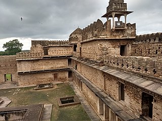
<span class="mw-page-title-main">Sagar, Madhya Pradesh</span> City in Madhya Pradesh, India

Sagar is a city, municipal corporation and administrative headquarter in Sagar district of the state of Madhya Pradesh in central India. The city is situated on a spur of the Vindhya Range, 1,758 feet (536 m) above sea-level around 172 kilometres (107 mi) northeast of the state capital, Bhopal.

<span class="mw-page-title-main">Vidisha</span> City in Madhya Pradesh, India

Vidisha is a city in central Madhya Pradesh, India. It is located 62.5 km northeast of the state capital, Bhopal. The name "Vidisha" is derived from the nearby river "Bais", mentioned in the Puranas.

Kurwai is a town and a Nagar Panchayat in Vidisha district in the Indian state of Madhya Pradesh. its also tehsil headquarter and assembly constituency.

Ashoknagar is a city and a Municipality Council in Ashoknagar District in Madhya Pradesh state of central India. It is the administrative headquarters of Ashoknagar District. Earlier it was part of Guna district. Ashoknagar is well known for its Grain Mandi and "Sharbati Gaihu", a type of wheat. The nearest city Guna 45 km from the city. Ashoknagar was formerly known as Pachar. The railway line passes from the middle of the city. Ashoknagar has a railway station and Two Bus stations. Ashoknagar is connected to the main cities of Madhya Pradesh by road and railway.

<span class="mw-page-title-main">Ashoknagar district</span> District of Madhya Pradesh in India

Ashoknagar District is a district of Madhya Pradesh state in central India. The city of Ashoknagar is the administrative headquarters of the district. Ashoknagar district was formed in 2003.

<span class="mw-page-title-main">Tikamgarh district</span> District of Madhya Pradesh in India

Tikamgarh district is one of the 52 districts of Madhya Pradesh state in central India. Tikamgarh town is the district headquarters. The district is part of Sagar Division.

<span class="mw-page-title-main">Vidisha district</span> District of Madhya Pradesh in India

Vidisha District (विदिशा) is in Madhya Pradesh state, in central India. The city of Vidisha is the administrative headquarters of the district.

<span class="mw-page-title-main">Khargone</span> City in Madhya Pradesh, India

Khargone is a city and administrative headquarters of an Khargone district in the Indian state of Madhya Pradesh. The city is located on the bank of the Kunda river and is known for its cotton and chilly production. It is also known for Navgraha Mandir, a temple devoted to the nav grahas. Khargone topped the nation in municipality and received a national award for 'India's Fastest Moving City' under a population of two lakh. Khargone ranked 10th Cleanest city in India in Swachh Survekshan 2020 City ranked the 15th cleanest city in India in Swachh Survekshan 2018 and ranked 17th cleanest city in India in Swachh Survekshan 2017.

Mandi Bamora is a census town in Sagar district in the state of Madhya Pradesh, India. This place has a railway station Mandi Bamora. Mandi Bamora located as half- half way in two different district Bina-etawa and Vidisha. Tehsil is Bina. Mandi Bamora is very famous as a name "Great country" because two different districts boundaries separated two places Bamora and Sihora.

Bareli is a town and a Municipality in Raisen district in the state of Madhya Pradesh, India. It is located in the Bareli tehsil. Bareli is a town in the Raisen district. There is a sub-jail in Bareli. Bareli is located on bank of Barna River. Bareli has National Krishi Upaj Mandi and it produces Wheat, Soyabean, Rice and different vegetable in different seasons. Bareli is connected with National Highway that connects to Bhopal and Jabalpur via NH-12(or NH-45)

Biaora is a city and municipality in Rajgarh district in the state of Madhya Pradesh, India. biaora is one of the six tehsils of rajgarh district. The primary languages spoken in biaora are Malvi, English and Hindi. It is situated on National Highway NH-3 and Jaipur National Highway.

Raghogarh-Ruthiyai or Raghogarh-Vijaypur is a town and municipality in Guna district in the Indian state of Madhya Pradesh.

Shirpur is a town and taluka in Dhule district of Nashik Division, Maharashtra, India. It is located on National Highway 3, which runs from Agra in Uttar Pradesh to Mumbai, Maharashtra. The Arunavati River and Tapi river flows through the city. Shirpur is 50 km from the city of Dhule. It houses Asia's largest and India's first gold refinery. Narsee Monjee Institute of Management Studies has a campus in Shirpur. Ahead of Shirpur there is a small private airport at Village Tande.

<span class="mw-page-title-main">Parwar (Jain community)</span>

Parwar, also spelt as Paravāra, is a major Jain community from the Bundelkhand region, which is largely in Madhya Pradesh, but also includes the two districts of Lalitpur and Jhansi in Uttar Pradesh. Apart from them, Nagpur district (Maharashtra) have also a very large Parwar community. There is an area in Itwari of Nagpur known as Parwar-Pura having large number of Parwar's homes and shops. Most of the Nagpur's Parwar are migrated from Sagar, Deori, and other small villages of Sagar District of MP. Parwar exclusively follow the Digambar Jain tradition. Parwar usually preferred their marriage within community. There are 12 Gotra in Parwar community. Each Gotra has 12 Moor (lineages). A marriage within the same gotra or lineage are not allowed. Traditionally a marriage within any of the 8 branches was not permitted and hence the community was termed ashta-shakha.

The Taran Panth, also known as Taran Svami Panth, Taran Samaj or Taranapanthi, is a sect of Digambara Jainism founded by Taran Svami in Bundelkhand in central India in c. 1505 CE.

<span class="mw-page-title-main">Majhgawan</span> Town in Madhya Pradesh, India

Majhgawan is a town located in Satna District, Madhya Pradesh, about 16 km north of Kothi and 42 km from Satna, the administrative headquarters of the district. Majhgawan is mostly laid out over hills covered with dense forests and is part of the reserve forest areas of Madhya Pradesh.

Ganj Basoda, called Basoda, city and municipality in the Indian state of Madhya Pradesh. Ganj Basoda is one of the eleven tehsils of Vidisha district and is 39 km from Vidisha.

Bina Thermal Power Plant is a coal based thermal power project located at Bina Etawa in Sagar district in Indian state of Madhya Pradesh. The power plant is one of the coal based power plants of Jaypee Group. Current talks of this power plant being sold to Jindal owned JSW Energy are under progress.

References

  1. "Bina-Etawa Population". Census2021. census2021.co.in. Retrieved 13 April 2017.[ permanent dead link ]
  2. 1 2 "Bharat Oman Refineries Limited". Bharat Oman Refineries Limited. Archived from the original on 14 December 2007.
  3. "Profile of Bina-Etawa, History of Bina-Etawa, Facts About Bina-Etawa". bina-etawa.mponline.in. Archived from the original on 14 December 2007. Retrieved 23 April 2024.
  4. "Profile of Bina Etawa, History of Bina Etawa, Facts About Bina Etawa". bina-etawa.mponline.in. Retrieved 11 November 2023.
  5. "Places of Interest at Sagar District". Archived from the original on 14 January 2013. Retrieved 2013-11-04.
  6. "Home". borl.in.
  7. "Jaypee Group | Businesses-Power". Archived from the original on 25 November 2013. Retrieved 2013-11-04.
  8. "Power Grid – Company Overview". Archived from the original on 15 May 2013. Retrieved 4 November 2013.
  9. http://www.investmp.com/a-corridors.html%5B%5D
  10. "Profile of Bina Etawa,History of Bina-Etawa,Facts About Bina-Etawa". bina-etawa.mp online.in. Retrieved 11 November 2023.
  11. "Online Hand-Written Digamber Jain Books (Manuscripts)". www.idjo.org. Archived from the original on 4 November 2013. Retrieved 26 January 2022.
  12. "यहां हुई थी फिल्म 'तीसरी कसम' की शूटिंग, रिलीज को हुए 50 साल पूरे- m.bhaskar.com". Archived from the original on 10 December 2016. Retrieved 28 November 2021.
  13. "When Waheeda sat on Raj". The Telegraph . 29 March 2014. Retrieved 21 February 2024.