
North Walsham is a market town and civil parish in Norfolk, England, within the North Norfolk district.

South Norfolk is a local government district in Norfolk, England. Its council is based in Long Stratton. The population of the Local Authority District was 124,012 as taken at the 2011 Census.

Corton is a village and civil parish in the north of the English county of Suffolk. It is 3 miles (4.8 km) north of the centre of Lowestoft in the East Suffolk district. The village is on the North Sea coast with the county border with Norfolk to the north. It is a seaside holiday centre, with a number of facilities for visitors. Great Yarmouth is 6 miles (9.7 km) to the north.

Beachamwell is a village and civil parish in the Breckland district of Norfolk, England about 5 miles (8.0 km) south west of Swaffham and 10 miles (16 km) east of Downham Market. It has four ancient churches, two of them in ruins. The former parish of Shingham has been annexed.

Salle is a small village and civil parish in Norfolk, England. 1.5 miles (2.4 km) to the south is the market town of Reepham.

Burgh St Peter is a village and civil parish in the South Norfolk district of Norfolk, England. The village is about 3+1⁄2 miles (6 km) northeast of Beccles in Suffolk. The village is about 50 feet (15 m) above sea level, sharing the same slight hill with Wheatacre about 1⁄2 mile (800 m) to the northwest.

Bylaugh is a civil parish in Norfolk, England 4.5 miles (7.2 km) north-east of East Dereham and 13.5 miles (21.7 km) WNW of Norwich. For the purposes of local government it falls within the Upper Wensum Ward of Breckland District Council and the Elmham and Mattishall Division of Norfolk County Council. According to the 2001 census it had a population of 65. At the 2011 census the population remained less than 100 and was included in the civil parish of Sparham.

Wramplingham is a village and civil parish in the English county of Norfolk. It is situated on the River Tiffey some 4 miles (6.4 km) north of Wymondham and 7 miles (11 km) west of Norwich. The civil parish has an area of 3.47 square kilometres and in 2001 had a population of 110 in 44 households, increasing to a population of 115 in 51 households at the 2011 Census. For the purposes of local government, the parish falls within the district of South Norfolk.
Plumtree is a village and civil parish in the borough of Rushcliffe, Nottinghamshire. At the time of the 2001 census it had a population of 221, increasing to 246 at the 2011 census. It is situated 5 miles south east of Nottingham, between the villages of Tollerton and Keyworth. Some of the farming land around the village is owned by the Duchy of Cornwall. The parish church of St Mary has a Norman tower on Saxon foundations, which were found when the tower was rebuilt in 1906. The nave is of 13th-century date. The north aisle was rebuilt and extended with stone from Nottingham's medieval Trent Bridge in 1873. Edward Hagarty Parry (1855–1931), an association footballer who captained Old Carthusians F.C. when they won the 1881 FA Cup Final against Old Etonians, is buried in the churchyard.

Caistor St Edmund is a village and former civil parish on the River Tas, now in the parish of Caistor St Edmund and Bixley, South Norfolk, England. The parish covered an area of 6.55 square kilometres (2.53 sq mi) and had a population of 270 in 116 households at the 2001 census, the population increasing to 289 at the 2011 Census. On the 1st of April 2019 the parish was merged with Bixley to form Caistor St Edmund and Bixley.
Lyng is a village and civil parish in the English county of Norfolk. It is situated on the River Wensum, some 10 km (6.2 mi) north-east of the town of East Dereham and 20 km (12 mi) north-west of the city of Norwich.
Mutford is a village and civil parish in the East Suffolk District of the English county of Suffolk. The village is 5 miles (8.0 km) south-west of Lowestoft and 4 miles (6.4 km) south-east of Beccles in a rural area. The parish borders Barnby, Carlton Colville, Gisleham, Rushmere, Henstead with Hulver Street, Ellough and North Cove. The village gave its name to the Half Hundred of Mutford which is named in the Domesday Book.

Pudding Norton is a village and civil parish in the English county of Norfolk. It covers an area of 2.30 sq mi (6.0 km2) and had a population of 267 in 126 households at the 2001 census, falling to 252 at the 2011 Census. For the purposes of local government, it falls within the district of North Norfolk.

Stoke Holy Cross is a village in South Norfolk which lies approximately 4 miles (6.4 km) south of Norwich.
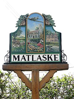
Matlaske is a village and a civil parish in the English county of Norfolk. The village is 21.6 miles (34.8 km) North-north-west of Norwich, 9.3 miles (15.0 km) south-west of Cromer and 136 miles (219 km) north-north-east of London. The nearest railway station is at Sheringham for the Bittern Line which runs between Sheringham, Cromer and Norwich. The nearest airport is Norwich International Airport. The parish of Matlask in the 2001 census, a population of 124, increasing to 139 at the 2011 Census. For the purposes of local government, the parish falls within the district of North Norfolk.

Lound is a village and civil parish in the north of the English county of Suffolk. It is 4.5 miles (7.2 km) north of Lowestoft, 5 miles (8.0 km) south of Great Yarmouth in the East Suffolk district. It is 2 miles (3.2 km) from the North Sea coast at Hopton-on-Sea and is on the border with the county of Norfolk.

Little Cressingham lies 2.5 miles (4.0 km) south east by road from Great Cressingham, 3 miles (4.8 km) west of Watton and 8 miles (13 km) south of Swaffham in the Breckland District of Norfolk. It covers an area of 11.90 km2 (4.59 sq mi) and had a population of 157 in 70 households at the 2001 census It is in the civil parish of Great Cressingham. The village is located on the edge of the Stanford Battle Area.
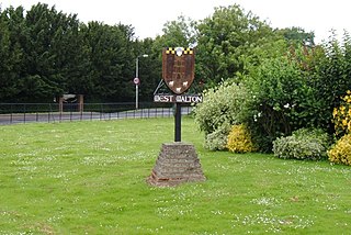
West Walton is a village and civil parish in the King's Lynn and West Norfolk District of Norfolk, England.

Leziate is a village and civil parish in the English county of Norfolk. The village is 44 miles (71 km) west of Norwich, 5.7 miles (9.2 km) east of King's Lynn and 106 miles (171 km) north-north-east of London. The Village is located a small distance south of the B1145 a route which runs between King's Lynn and Mundesley. The nearest railway station is at King's Lynn for the Fen Line which runs between King's Lynn and Cambridge. The nearest airport is Norwich International Airport. The parish of Leziate in the 2001 census, has a population of 581, including Ashwicken and increasing to 592 at the 2011 census.

