Bramley & Wonersh railway station

Last updated

Bramley & Wonersh
Bramley and Wonersh station.jpg
General information
Location Bramley, Waverley, Surrey
England
Grid reference TQ010451
Platforms2
Other information
StatusDisused
History
Original company London, Brighton and South Coast Railway
Post-grouping Southern Railway
Southern Region of British Railways
Key dates
2 October 1865Opened as "Bramley"
1 June 1888Renamed "Bramley & Wonersh"
14 June 1965Closed

Bramley & Wonersh was a railway station on the Cranleigh Line. It served the villages of Bramley and Wonersh in Surrey.

Contents

History

A 1912 Railway Clearing House map of lines around Bramley & Wonersh railway station Aldershot, Ash, Shalford, Basingstoke, Guildford & Peasmarsh , Wimbledon RJD 4.jpg
A 1912 Railway Clearing House map of lines around Bramley & Wonersh railway station

Opened in 1865 as "Bramley", its name was changed in June 1888 to "Bramley & Wonersh" as the station, although situated in Bramley, was only a short distance from Wonersh. A passing loop and a second platform were installed in 1876. The station was the last before the line joined the main line to Guildford at Peasmarsh Junction.

In the Second World War a German Dornier 217 aircraft attacked a train carrying Christmas shoppers as it was departing Bramley & Wonersh on 16 December 1942. [1] The plane machine-gunned the train and dropped a bomb [1] that exploded on the embankment, narrowly missing the train. The driver and guard were killed, a number of passengers were killed or wounded and the train was badly damaged. The fireman and the porter-in-charge of Bramley station attended the wounded and dying, later helped by six soldiers who were billetted nearby. [1] Afterwards fireman William Fairey and porter-in-charge Violet Wisdom were presented with certificates of merit for their actions, and Miss Wisdom was singled out for her "great courage and resource directly the bombs had fallen". [1]

The line was closed in 1965 following The Reshaping of British Railways report of 1963, and the main station building was demolished a few years later. The trackbed remained overgrown for many years before being brought back into use in the 1980s as part of the Downs Link, a public footpath and bridleway linking the North Downs and South Downs National Trails. In 2004 major renovation works were carried out at the station by the[ which? ] local council and the Bramley Historical Society.

Preceding station Disused railways Following station
Guildford
Line closed, station open
  London, Brighton and South Coast Railway
Horsham and Guildford Direct Railway
  Cranleigh
Line and station closed

Future

Studies of the feasibility of reopening the Guildford – Bramley – Cranleigh section of the line were completed in 1994, 1997 and 2009. The 1994 report concluded that the investment required would not justify reinstatement, but Waverley Borough Council has protected the line from development in its Local Plan. The 2009 report estimates that reopening the Guildford – Bramley – Cranleigh section would have a positive benefit-cost ratio of 1.7 to 1 including capital costs. [2]

Other Cranleigh Line stations

See also

Related Research Articles

<span class="mw-page-title-main">Cranleigh</span> Village in England

Cranleigh is a village and civil parish, about 8 miles (13 km) southeast of Guildford in Surrey, England. It lies on a minor road east of the A281, which links Guildford with Horsham. It is in the north-west corner of the Weald, a large remnant forest, the main local remnant being Winterfold Forest directly north-west on the northern Greensand Ridge.

<span class="mw-page-title-main">Bramley, Surrey</span> Village and civil parish in Surrey, England

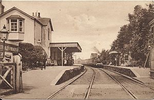
Bramley is a village and civil parish about three miles (5 km) south of Guildford in the Borough of Waverley in Surrey, south east England. Most of the parish lies in the Surrey Hills Area of Outstanding Natural Beauty.

<span class="mw-page-title-main">Wisbech and March line</span> Disused railway in East Anglia, England

The Wisbech and March line is a railway line between March and Wisbech in Cambridgeshire, England. A number of proposals are currently being investigated relating to the possible restoration of passenger services along the route.

<span class="mw-page-title-main">East Coastway line</span> Railway line in Sussex, England

The East Coastway line is a railway line along the south coast of Sussex to the east of Brighton, England. Trains to the west of Brighton operate on the West Coastway line. Together with the West Coastway and the Marshlink line to the east, the line forms part of a continuous route from Havant to Ashford. The Brighton Main Line route to Eastbourne and Hastings, via Plumpton and Cooksbridge, shares the East Coastway line east of Lewes station.

<span class="mw-page-title-main">Sandhurst railway station</span> Railway station in Berkshire, England


Sandhurst railway station, known by National Rail as Sandhurst (Berks), serves the town of Sandhurst in Berkshire, England. The station is managed by Great Western Railway, who operate services on the North Downs Line from Reading to Guildford, Redhill and Gatwick Airport. The station is located 11.5 miles (18.5 km) south-east of Reading.

<span class="mw-page-title-main">Guildford railway station</span> Railway station in Guildford, Surrey, England

Guildford railway station is at one of three main railway junctions on the Portsmouth Direct Line and serves the town of Guildford in Surrey, England. It is 30 miles 27 chains down the line from London Waterloo via Woking.

<span class="mw-page-title-main">North Downs Line</span> Railway line in England, linking Reading and Reigate

The North Downs Line is a passenger-train line connecting Reading to Redhill and Gatwick Airport, along the Brighton Main Line, linking many centres of population in that part of the North Downs which it traverses en route.

<span class="mw-page-title-main">Guildford (UK Parliament constituency)</span>

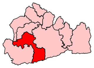
Guildford is a constituency in Surrey represented in the House of Commons of the UK Parliament since 2019 by Angela Richardson, a Conservative.

The Southern Region was a region of British Railways from 1948 until 1992 when railways were re-privatised. The region ceased to be an operating unit in its own right in the 1980s. The region covered south London, southern England and the south coast, including the busy commuter belt areas of Kent, Sussex and Surrey. The region was largely based upon the former Southern Railway area.

<span class="mw-page-title-main">Christ's Hospital railway station</span> Railway station in West Sussex, England

Christ's Hospital railway station is near Horsham in West Sussex, England. It is 40 miles 7 chains (64.5 km) down the line from London Bridge via Redhill. It was opened in 1902 by the London, Brighton and South Coast Railway and was intended primarily to serve Christ's Hospital, a large private school which had moved to the area in that year. It now also serves the rural area to the west of Horsham.

<span class="mw-page-title-main">Chilworth, Surrey</span> Village in England

Chilworth is a village in the Guildford borough of Surrey, England. It is located in the Tillingbourne valley, southeast of Guildford.

<span class="mw-page-title-main">Wonersh</span> Human settlement in England

Wonersh is a village and civil parish in the Waverley district of Surrey, England and Surrey Hills Area of Outstanding Natural Beauty. Wonersh contains three Conservation Areas and spans an area three to six miles SSE of Guildford.

<span class="mw-page-title-main">Slinfold railway station</span> Former railway station in England

Slinfold railway station was on the Cranleigh Line and served the village of Slinfold in West Sussex.

<span class="mw-page-title-main">Chilworth railway station</span> Railway station in Surrey, England

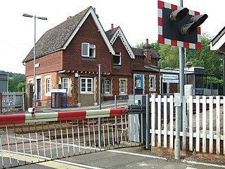
Chilworth railway station serves the village of Chilworth, Surrey, England. The station, and all trains serving it, are operated by the Great Western Railway. It is on the North Downs Line, 39 miles 15 chains measured from London Charing Cross via Redhill.

<span class="mw-page-title-main">Downs Link</span> Footpath in England, United Kingdom

The Downs Link is a 36.7 miles (59.1 km) footpath and bridleway linking the North Downs Way at St. Martha's Hill in Surrey with the South Downs Way near Steyning in West Sussex and on via the Coastal Link to Shoreham-by-Sea.

<span class="mw-page-title-main">Baynards railway station</span> Disused railway station in Baynards Park, Surrey

Baynards was a railway station on the Cranleigh Line, between Guildford, Surrey, and Horsham, West Sussex, England. The station opened with the line on 2 October 1865.

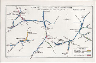
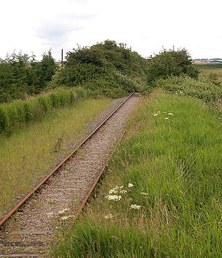
The Cranleigh line was a railway line in England that connected Guildford in Surrey, with Horsham in West Sussex. Construction of the line was started by an independent company, the Horsham and Guildford Direct Railway, but management failures delayed construction, and the company was taken over by the London, Brighton and South Coast Railway (LBSCR). The LBSCR completed the construction of the line and it was opened in 1865; it was nearly 16 miles in length.

<span class="mw-page-title-main">Cranleigh railway station</span> Former railway station in England

Cranleigh was a railway station on the Cranleigh Line between Guildford and Horsham. It served the village of Cranleigh, Surrey in southern England.

<span class="mw-page-title-main">Rudgwick railway station</span> Former railway station in England

Rudgwick railway station was on the Cranleigh Line. It served the village of Rudgwick in West Sussex until June, 1965.

Connecting Communities: Expanding Access to the Rail Network is a 2009 report by the Association of Train Operating Companies (ATOC) identifying potential expansion of the National Rail passenger railway network in England, primarily through the construction or re-opening of railway lines for passenger services, and the construction or re-opening of up to 40 new passenger railway stations.

References

  1. 1 2 3 4 Wojtczak, Helena (2005). Railwaywomen: Exploitation, Betrayal and Triumph in the Workplace. Hastings: Hastings Press. p. 149. ISBN   1-904109-04-7.
  2. Connecting Communities: Expanding Access to the Rail Network . London: Association of Train Operating Companies. June 2009. pp. 16, 18.

51°11′46″N0°33′21″W / 51.19620°N 0.55592°W / 51.19620; -0.55592