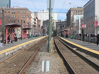
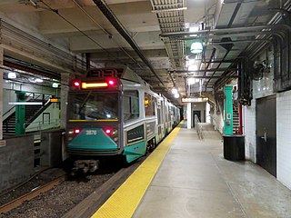
The Green Line is a light rail system run by the Massachusetts Bay Transportation Authority (MBTA) in the Boston, Massachusetts, metropolitan area. It is the oldest Boston rapid transit line, and with tunnel sections dating from 1897, the oldest in America. It runs as a deep-level subway through downtown Boston, and on the surface into inner suburbs via four branches on several radial boulevards. With an average daily weekday ridership of 152,200 in 2019, it is the second most heavily used light rail system in the country. The line was assigned the green color in 1967 during a systemwide rebranding because several branches pass through sections of the Emerald Necklace of Boston.
Route 9 is a 135.310-mile-long (217.760 km) major east–west state highway in Massachusetts. Along with U.S. Route 20, Route 2, and Interstate 90, Route 9 is one of the major east–west routes of Massachusetts, and like the others its eastern terminus is in Boston. Starting at Copley Square and passing along Huntington Avenue, Route 9 is a limited access route through the MetroWest suburbs to Worcester, and is also a major alternative to the Pike's toll road west of the city. After passing along major city streets in Worcester, the road becomes a country route, passing through the central Worcester Hills, the Pioneer Valley, and the city of Northampton, and into The Berkshires. The road ends near the center of the city of Pittsfield.

Longwood Medical Area is a light rail stop on the MBTA Green Line E branch, located in the Mission Hill neighborhood of Boston, Massachusetts. It is the named for the adjacent Longwood Medical Area.

Brigham Circle is a station on the light rail MBTA Green Line "E" branch, located just east of Brigham Circle in the Mission Hill neighborhood of Boston, Massachusetts. With raised platforms installed in a 2001-03 renovation, the station is accessible when served by low-floor streetcars.
Northeastern University is a surface-level trolley stop on the MBTA Green Line. It is located in a dedicated median along Huntington Avenue in Boston, between Opera Place and Forsyth Street, and is adjacent to the Krentzman Quad on the campus of Northeastern University. It is the first surface-level stop going outbound along the Green Line E branch; trolleys rise from a portal located between Opera Place and Gainsborough Street and continue along the surface down Huntington Avenue towards Mission Hill.
Cleveland Circle, an area of Boston, Massachusetts, is located in Boston's Brighton neighborhood, and more specifically the Aberdeen section of Brighton, in very close proximity to Brookline and Chestnut Hill, Massachusetts, at the intersection of Beacon Street and Chestnut Hill Avenue.

Forest Hills is an intermodal transfer station in Boston, Massachusetts. It serves the MBTA's rapid transit Orange Line, MBTA Commuter Rail's Needham Line, and is a major terminus for MBTA Bus routes. It is located in Forest Hills, in the southern part of the Jamaica Plain neighborhood. The Providence/Stoughton Line and Franklin Line, as well as Amtrak's Acela Express and Northeast Regional trains, pass through the station without stopping.

Heath Street is an MBTA transit station in Boston, Massachusetts. It is the terminus of the Green Line E branch. It is located at the intersection of South Huntington Avenue and Heath Street on the border between the Mission Hill and Jamaica Plain neighborhoods. The station is accessible when served by the MBTA's newer low-floor trolley cars and buses.

Key bus routes of the Massachusetts Bay Transportation Authority (MBTA) system are 15 routes that have high ridership and higher frequency standards than other bus lines, according to the 2004 MBTA Service Policy. Together, they account for roughly 40% of the MBTA's total bus ridership. These key bus routes ensure basic geographic coverage with frequent service in the densest areas of Boston, and connect to other MBTA services to give access to other areas throughout the region.

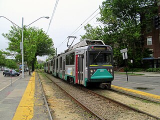
The E branch is a streetcar line in the Boston, Massachusetts area, operating as a branch of the Massachusetts Bay Transportation Authority Green Line. From 1985 to 2011, service beyond Heath Street to the original outbound terminus at Arborway was "temporarily" suspended, with the route 39 bus providing service beyond; service restoration was officially canceled in 2011 after the defeat of a lawsuit. The segment of the line between Brigham Circle and Heath Street is the only remaining section of street-running tracks in revenue use by the MBTA; all other trackage is in tunnels and bridges, on private rights-of-way, in reserved medians, or is used for out-of-service trains.

The C branch, also called the Beacon Street Line or Cleveland Circle Line, is one of four branches of the Massachusetts Bay Transportation Authority's Green Line light rail system in the Boston, Massachusetts metropolitan area. The line begins at Cleveland Circle in the Brighton neighborhood of Boston and runs on the surface through Brookline along the median of Beacon Street. Reentering Boston, the line goes underground through the St. Marys Street incline and joins the B and D branches at Kenmore. Trains run through the Boylston Street subway to Copley where the E branch joins, then continue through the Tremont Street subway to downtown Boston. As of 2020, the C branch terminates at North Station.

The B branch, also called the Commonwealth Avenue branch or Boston College branch, is a branch of the MBTA Green Line light rail system which operates on Commonwealth Avenue west of downtown Boston, Massachusetts. One of four branches of the Green Line, the B branch runs from Boston College station down the median of Commonwealth Avenue to Blandford Street. There, it enters Blandford Street portal into Kenmore station, where it merges with the C and D branches. The combined services run into the Boylston Street subway and Tremont Street subway to downtown Boston. As of 2016, B branch service terminates at Park Street. Unlike the other branches, the B branch runs solely through the city limits of Boston.
Prudential is an underground light rail station on the MBTA Green Line E branch, located below Huntington Avenue next to the Prudential Tower complex near Belvidere Street in Boston, Massachusetts. Prudential station is fully handicapped accessible, featuring low raised platforms and elevator service to the Huntington Arcade of the Shops at Prudential Center at the base of the Prudential Tower.

Mission Hill is a ¾ square mile neighborhood of Boston. Many medical and educational institutions are nearby. The population was estimated at 15,883 in 2011.

Huntington Avenue is a secondary thoroughfare in the city of Boston, Massachusetts, beginning at Copley Square, and continuing west through the Back Bay, Fenway, Longwood, and Mission Hill neighborhoods. Huntington Avenue is signed as Route 9. A section of Huntington Avenue has been officially designated the Avenue of the Arts by the city of Boston.

Mission Park is a light rail stop on the MBTA Green Line E branch, located on Huntington Avenue in the Mission Hill neighborhood of Boston, Massachusetts.

Brookline Village is a light rail stop on the MBTA Green Line D branch, located in the Brookline Village neighborhood of Brookline, Massachusetts, United States. It was originally a commuter rail station on the Boston and Albany Railroad's Highland branch; it closed with the rest of the line in 1958 and reopened on July 4, 1959 as a light rail station. With 3,230 daily boardings, it is the third-busiest surface station on the D branch and the sixth-busiest surface station overall.

Riverway is a light rail station on the MBTA Green Line E branch, located at the intersection of South Huntington Avenue and Huntington Avenue in Boston, Massachusetts, slightly east of Brookline Village. The station is named for the Riverway parkway which runs on an overpass just to the west.

David G. Farragut Elementary School, also known as The Farragut School, was a public elementary school located at 10 Fenwood Road, in the Mission Hill district of Boston, Massachusetts, just off of Huntington Avenue. The school was located near the Brigham Circle trolley-train stop on the "E" branch of the MBTA's Green Line and Brigham and Women's Hospital.

The Ipswich Street line was a streetcar line in Boston and Brookline, Massachusetts. The line ran on Boylston Street and Ipswich Street in the Fenway–Kenmore neighborhood, and on Brookline Avenue through what is now the Longwood Medical Area to Brookline Village.

