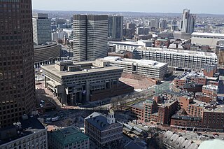
Government Center is an area in downtown Boston, centered on City Hall Plaza. Formerly the site of Scollay Square, it is now the location of Boston City Hall, courthouses, state and federal office buildings, and a major MBTA subway station, also called Government Center. Its development was controversial, as the project displaced thousands of residents and razed several hundred homes and businesses.

Scollay Square was a vibrant city square in downtown Boston, Massachusetts. It was named for William Scollay, a prominent local developer and militia officer who bought a landmark four-story merchant building at the intersection of the Cambridge and Court Streets in the year 1795. Local citizens began to refer to this intersection as Scollay's Square, and, in 1838, the city officially memorialized the intersection as the Scollay Square. Early on, the area was a busy center of commerce, including daguerreotypist (photographer) Josiah Johnson Hawes (1808–1901) and Dr. William Thomas Green Morton, the first dentist to use ether as an anaesthetic.

Long Wharf is a historic American pier in Boston, Massachusetts, built between 1710 and 1721. It once extended from State Street nearly a half-mile into Boston Harbor; today, the much-shortened wharf functions as a dock for passenger ferries and sightseeing boats.

Tremont Street is a major thoroughfare in Boston, Massachusetts.

Charles Street is the name of a north-south street in the city center of Boston, Massachusetts. It begins in the north at Leverett Circle, where it connects with Nashua Street and Monsignor O'Brien Highway. Science Park station on the MBTA Green Line is located there. Charles Street runs south and gives its name to the Charles/MGH station on the MBTA Red Line, connecting via the Charles Circle rotary to Cambridge Street and the Longfellow Bridge which leads to Cambridge. This segment is a one-way street, with traffic heading northwards.

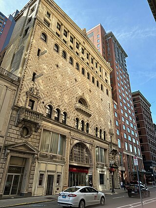
The Tremont Temple on 88 Tremont Street is a Baptist church in Boston, Massachusetts, affiliated with the American Baptist Churches, USA. The existing multi-storey, Renaissance Revival structure was designed by Boston architect Clarence Blackall, and opened in May 1896. It replaced a much smaller 1827 structure which had repeatedly suffered damage by fires.

State Street is one of the oldest and most historic streets in Boston, Massachusetts, United States. Located in the financial district, it is the site of some historic landmarks, such as Long Wharf, the Old State House and the Boston Custom House.

William Pembroke Fetridge (1827-1896) was a travel writer, publisher, bookseller and periodicals distributor. He lived in the Boston, Massachusetts area and in Paris, France.

Brattle Street, which existed from 1694 to 1962, was a street in Boston, Massachusetts, located on the current site of City Hall Plaza, at Government Center.
Union Street is a street in Government Center, Boston, Massachusetts, near Faneuil Hall. Prior to 1828, it was also called Green Dragon Lane.

Congress Street in Boston, Massachusetts, is located in the Financial District and South Boston. It was first named in 1800. It was extended in 1854 as far as Atlantic Avenue, and in 1874 across Fort Point Channel into South Boston. Today's Congress Street consists of several segments of streets, previously named Atkinson's Street, Dalton Street, Gray's Alley, Leverett's Lane, Quaker Lane, and Shrimpton's Lane.

Dock Square in downtown Boston, Massachusetts, is a public square adjacent to Faneuil Hall, bounded by Congress Street, North Street, and the steps of the 60 State Street office tower. Its name derives from its original (17th-century) location at the waterfront. From the 1630s through the early 19th century, it served boats in the Boston Harbor as "the common landing place, at Bendell's Cove," later called Town Dock. "Around the dock was transacted the chief mercantile business of the town." After the waterfront was filled in during the early 19th century, Dock Square continued as a center of commerce for some years. The addition in the 1960s of Government Center changed the scale and character of the square from a hub of city life, to a place one merely passes through. As of the 1950s the square has become largely a tourist spot, with the Freedom Trail running through it. John Winthrop, coming from Salem where he landed as a Puritan from England, ended up "setting up a dock at the head of the cove, and here began the town of Boston, which soon was recognized as the political and economic center of the [Massachusetts Bay] colony.

Merchants Row in Boston, Massachusetts, is a short street extending from State Street to Faneuil Hall Square in the Financial District. Since the 17th century, it has been a place of commercial activity. It sits close to Long Wharf and Dock Square, hubs of shipping and trade through the 19th century. Portions of the street were formerly known as Swing-Bridge Lane, Fish Lane, and Roebuck Passage.

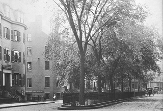
Pemberton Square in the Government Center area of Boston, Massachusetts, was developed by P.T. Jackson in the 1830s as an architecturally uniform mixed-use enclave surrounding a small park. In the mid-19th century both private residences and businesses dwelt there. The construction in 1885 of the massive John Adams Courthouse changed the scale and character of the square, as did the Center Plaza building in the 1960s.

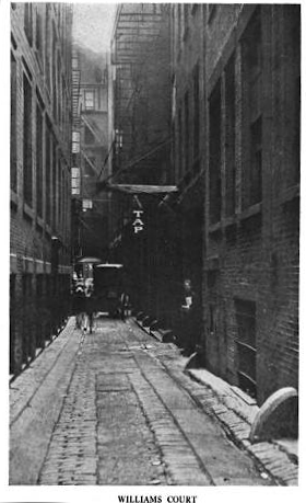
Pi Alley in Boston, Massachusetts, is located off Washington Street, near the Old City Hall on School Street. The origin of the short street's name remains in question. It may be named after the pied type which newspaper composing rooms dumped into the alley in the past, or after the local restaurants that sold coffee and a piece of pie for a nickel. It is also known as Williams Court, Savage's Court, Peck's Arch, and Webster's Arch.

Cornhill was a street in Boston, Massachusetts, in the 18th, 19th and 20th centuries, located on the site of the current City Hall Plaza in Government Center. It was named in 1829; previously it was known as Market Street (1807–1828). In its time, it comprised a busy part of the city near Brattle Street, Court Street and Scollay Square. In the 19th century, it was the home of many bookstores and publishing companies. As of 1969, Cornhill exists as 144 feet along the edge of City Hall Plaza.

Mount Vernon Church in Boston, Massachusetts, was a Congregational church located on Beacon Hill (1844–1891) and later in Back Bay (1892–present).

Occupy Boston was a collective of protesters that settled on September 30, 2011 in Boston, Massachusetts, on Dewey Square in the Financial District opposite the Federal Reserve Bank of Boston. It is related to the Occupy Wall Street movement that began in New York City on September 17, 2011.

A Once and Future Shoreline is a permanent public artwork that graphically marks the edge of Boston Harbor, circa 1630, into the granite paving blocks of the plaza on the West side of the historic Faneuil Hall building. The 850-foot-long artwork depicts the location of a pre-colonial shoreline by graphically etching silhouettes of materials that are found typically along the high tide line. The artwork offers a way to engage the imagination in an exploration of the changes to this now urban site from a salty tidal marsh, to an active pedestrian plaza.


