
The Red Line is a rapid transit line operated by the Massachusetts Bay Transportation Authority (MBTA) as part of the MBTA subway system. The line runs south and east underground from Alewife station in North Cambridge through Somerville and Cambridge, surfacing to cross the Longfellow Bridge then returning to tunnels under Downtown Boston. It continues underground through South Boston, splitting into two branches on the surface at JFK/UMass station. The Ashmont branch runs southwest through Dorchester to Ashmont station, where the connecting light rail Ashmont–Mattapan High Speed Line continues to Mattapan station. The Braintree branch runs southwest through Quincy and Braintree to Braintree station.

Dorchester is a Boston neighborhood comprising more than 6 square miles (16 km2) in the City of Boston, Massachusetts, United States. Originally, Dorchester was a separate town, founded by Puritans who emigrated in 1630 from Dorchester, Dorset, England, to the Massachusetts Bay Colony. This dissolved municipality, Boston's largest neighborhood by far, is often divided by city planners in order to create two planning areas roughly equivalent in size and population to other Boston neighborhoods.

The Ashmont–Mattapan High-Speed Line, commonly referred to as the Mattapan Trolley, is a partially grade-separated light rail line which forms part of the MBTA's Red Line rapid transit line. The line, which runs through Boston and Milton, Massachusetts, opened on August 26, 1929, as a conversion of a former commuter rail line. It exclusively uses PCC streetcars built in the 1940s. Passengers must transfer at Ashmont to access the rest of the Red Line, which uses heavy rail metro rolling stock.
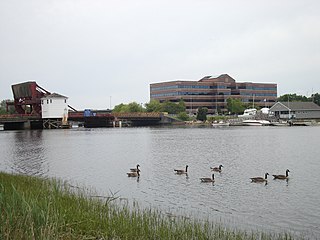
The Neponset River is a river in eastern Massachusetts in the United States. Its headwaters are at the Neponset Reservoir in Foxborough, near Gillette Stadium. From there, the Neponset meanders generally northeast for about 29 miles (47 km) to its mouth at Dorchester Bay between Quincy and the Dorchester section of Boston, near the painted gas tank.

JFK/UMass station is a Massachusetts Bay Transportation Authority (MBTA) intermodal transfer station, located adjacent to the Columbia Point area of Dorchester, Boston, Massachusetts. It is served by the rapid transit Red Line; the Greenbush Line, Kingston/Plymouth Line, and Middleborough/Lakeville Line of the MBTA Commuter Rail system, and three MBTA bus routes. The station is named for the John F. Kennedy Presidential Library and Museum and the University of Massachusetts Boston, both located nearby on Columbia Point.

The Union Freight Railroad was a freight-only railroad connecting the railroads coming into the north and south sides of downtown Boston, Massachusetts. Almost its entire length was along Atlantic Avenue and Commercial Street. For most of its length, the Atlantic Avenue Elevated carried passengers above.
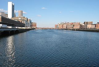
Fort Point Channel is a maritime channel separating South Boston from downtown Boston, Massachusetts, feeding into Boston Harbor. The south part of it has been gradually filled in for use by the South Bay rail yard and several highways. At its south end, the channel once widened into South Bay, from which the Roxbury Canal continued southwest where the Massachusetts Avenue Connector is now. The Boston Tea Party occurred at its northern end. The channel is surrounded by the Fort Point neighborhood, which is also named after the same colonial-era fort.
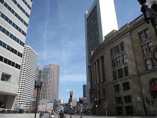
Atlantic Avenue is a street in downtown Boston, Massachusetts, partly serving as a frontage road for the underground Central Artery (I-93) and partly running along the Boston Harbor. It has a long history, with several relocations along the way.
The Central Artery is a section of freeway in downtown Boston, Massachusetts; it is designated as Interstate 93, US 1 and Route 3.

The Dorchester Railroad and Dorchester Extension Railroad was a horse car line in Boston, Massachusetts in the late 19th century, running from downtown south to Milton, mostly via Dorchester Avenue. For several years, it was operated by Gore, Rose and Company, owned by David Gore and George Rose, because the original company could not afford to run it.
Washington Street is a street originating in downtown Boston, Massachusetts, which extends southwestward to the Massachusetts–Rhode Island state line. The majority of its length outside of the city was built as the Norfolk and Bristol Turnpike in the early 19th century. It is the longest street in Boston and remains one of the longest streets in the Commonwealth of Massachusetts. Due to various municipal annexations with the city of Boston, the name Washington Street now exists 6 or more times within the jurisdiction(s) of the City of Boston.

As with many large cities, a large number of Boston-area streetcar lines once existed, and many continued operating into the 1950s. However, only a few now remain, namely the four branches of the Green Line and the Ashmont–Mattapan High-Speed Line, with only one running regular service on an undivided street.

Ashmont station is a Massachusetts Bay Transportation Authority (MBTA) intermodal transit station located at Peabody Square in the Dorchester neighborhood of Boston, Massachusetts. It is the southern terminus of the Ashmont branch of the rapid transit Red Line, the northern terminus of the connecting light rail Ashmont–Mattapan High-Speed Line, and a major terminal for MBTA bus service. Ashmont has two side platforms serving the below-grade Red Line and a single side platform on an elevated balloon loop for the Mattapan Line. The station is fully accessible for all modes.

Mattapan station is an MBTA light rail station in Boston, Massachusetts. It is the southern terminus of the Ashmont–Mattapan High-Speed Line, part of the Red Line, and is also an important MBTA bus transfer station, with eight routes terminating there. It is located at Mattapan Square in the Mattapan neighborhood. At the station, streetcars use a balloon loop to reverse direction back to Ashmont station. Mattapan station is fully accessible, with mini-high platforms.

Route 28 is a 151.93-mile-long (244.51 km) nominally south–north state highway in the U.S. state of Massachusetts, running from the town of Eastham via Boston to the New Hampshire state line in Methuen. Following the route from its nominally southern end, Route 28 initially heads south to the town of Chatham then turns west to follow along the south shore of Cape Cod. In Falmouth, Route 28 turns north and continues through the western part of Plymouth County and the eastern part of Norfolk County; it then passes through downtown Boston before heading north via Lawrence to the New Hampshire state line, where it continues as New Hampshire Route 28.

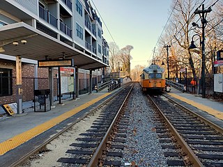
Milton station is a light rail station in Milton, Massachusetts. Located in the Dorchester-Milton Lower Mills Industrial District, it serves the MBTA's Ashmont–Mattapan High-Speed Line. This station is accessible via wooden ramps on both platforms.

Butler station is a light rail station in Boston, Massachusetts. It serves the MBTA Ashmont–Mattapan High-Speed Line. It is located at Butler Street in the Lower Mills section of the Dorchester neighborhood. It serves a small residential area sandwiched between the Neponset River, Cedar Grove Cemetery, and Dorchester Park. Butler station has no MBTA bus connections. It is accessible via a wooden mini-high ramp on the station's single island platform.
Central Avenue station is a light rail station located off Central Avenue near Eliot Street in Milton, Massachusetts. It serves the Ashmont–Mattapan High Speed Line, a branch of the MBTA Red Line. Central Avenue consists of two side platforms which serve the Ashmont–Mattapan High Speed Line's two tracks.

Capen Street station is a light rail station in Milton, Massachusetts. It serves the MBTA Ashmont–Mattapan High Speed Line. It is located on Capen Street off Eliot Street; the westernmost of the four MBTA stations in Milton, it consists of two side platforms flanking the eponymous street's grade crossing. The platforms are staggered to allow trains to make the stop at Capen Street before crossing the street itself, as there is no signal at the grade crossing. Capen Street is accessible via wooden ramps on both platforms. Capen Street opened in September 1930 as an infill station on the line.

The Dorchester and Milton Branch Railroad was a railroad in Massachusetts. It ran between Neponset Village in Dorchester, Massachusetts, through the town of Milton to the village of Mattapan. It was opened in 1847 and became part of the Old Colony Railroad system in 1848. The western portion was converted to a streetcar line in 1929, while the eastern portion remained in use for freight until the 1980s.


