Brattle Street (Boston)

Last updated
Brattle Street in Boston (1855) 1855 BrattleSt BostonianSociety.png
Brattle Street in Boston (1855)

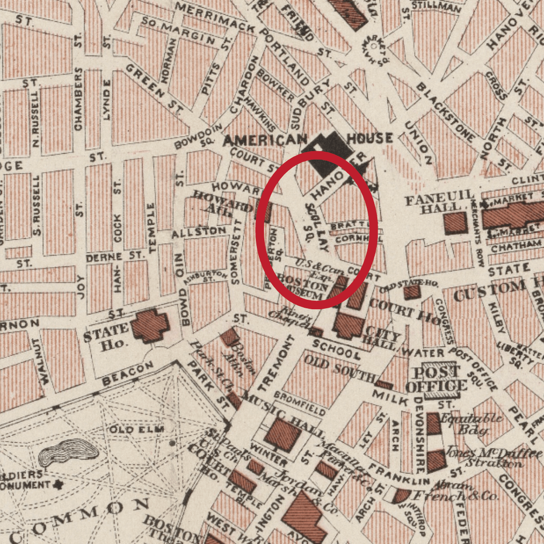
Brattle Street, which existed from 1694 to 1962, was a street in Boston, Massachusetts, located on the current site of City Hall Plaza, at Government Center. [1] [2] [3]

Contents

History

Around 1853, former Virginia slave Anthony Burns worked for "Coffin Pitts, clothing dealer, no.36 Brattle Street." [4] Nearby, abolitionist John P. Coburn managed a clothing store at 20 Brattle Street. [5] In 1850, Joshua Bowen Smith, a black abolitionist and member of Boston's Vigilance Committee, operated a catering business at 16 Brattle Street." [6]

In 1921, the first Radio Shack store opened at 46 Brattle Street. John Adams' Boston house and his law practice was on this street. During the bull dozing of Scolley Square, his house was not saved.

See also

Related Research Articles

<span class="mw-page-title-main">Anthony Burns</span> American escaped slave

Anthony Burns was an African-American man who escaped from slavery in Virginia in 1854. His capture and trial in Boston, and transport back to Virginia, generated wide-scale public outrage in the North and increased support for abolition.

<span class="mw-page-title-main">Bowdoin Street</span> Street in Boston, Massachusetts, USA

Bowdoin Street in Boston, Massachusetts, extends from the top of Beacon Street, down Beacon Hill to Cambridge Street, near the West End. It was originally called "Middlecott Street" as early as the 1750s. In 1805 it was renamed after the Governor James Bowdoin.

<span class="mw-page-title-main">Boston Vigilance Committee</span> US abolitionist organization

The Boston Vigilance Committee (1841–1861) was an abolitionist organization formed in Boston, Massachusetts, to protect escaped slaves from being kidnapped and returned to slavery in the South. The Committee aided hundreds of escapees, most of whom arrived as stowaways on coastal trading vessels and stayed a short time before moving on to Canada or England. Notably, members of the Committee provided legal and other aid to George Latimer, Ellen and William Craft, Shadrach Minkins, Thomas Sims, and Anthony Burns.

<span class="mw-page-title-main">Thomas Dalton (abolitionist)</span> American abolitionist

Thomas Dalton (1794–1883) was a free African American raised in Massachusetts who was dedicated to improving the lives of people of color. He was active with his wife Lucy Lew Dalton, Charlestown, Massachusetts, in the founding or ongoing activities of local educational organizations, including the Massachusetts General Colored Association, New England Anti-Slavery Society, Boston Mutual Lyceum, and Infant School Association, and campaigned for school integration, which was achieved in 1855.

<span class="mw-page-title-main">White Horse Tavern (Boston, Massachusetts)</span> Former tavern in Boston, Massachusetts, United States

The White Horse was a tavern in Boston, Massachusetts, in the 17th and 18th centuries. A well-known gathering place in colonial Boston, it "had a large square sign projecting over the footway, on which was delineated a white charger." Located near Boylston Street, the White Horse was frequently mentioned as a wayfinder to other establishments nearby.

<span class="mw-page-title-main">Brattle Street Church</span> Church building in Massachusetts, United States

The Brattle Street Church (1698–1876) was a Congregational and Unitarian church on Brattle Street in Boston, Massachusetts.

<span class="mw-page-title-main">Federal Street (Boston)</span>

Federal Street is a street in the Financial District of Boston, Massachusetts. Prior to 1788, it was known as Long Lane. The street was renamed after state leaders met there in 1788 to determine Massachusetts' ratification of the United States Constitution.

<span class="mw-page-title-main">Court Street (Boston)</span> Street in Boston, Massachusetts, US

Court Street is located in the Financial District of Boston, Massachusetts. Prior to 1788, it was called Prison Lane (1634–1708) and then Queen Street (1708–1788). In the 19th century it extended beyond its current length, to Bowdoin Square. In the 1960s most of Court Street was demolished to make way for the construction of Government Center. The remaining street extends a few blocks, near the Old State House on State Street.

<span class="mw-page-title-main">Franklin Street (Boston)</span>

Franklin Street is located in the Financial District of Boston, Massachusetts, United States. It was developed at the end of the 18th century by Charles Bulfinch, and included the now-demolished Tontine Crescent and Franklin Place.

<span class="mw-page-title-main">Congress Street (Boston)</span> Street in Boston, Massachusetts, US

Congress Street in Boston, Massachusetts, is located in the Financial District and South Boston. It was first named in 1800. It was extended in 1854 as far as Atlantic Avenue, and in 1874 across Fort Point Channel into South Boston. Today's Congress Street consists of several segments of streets, previously named Atkinson's Street, Dalton Street, Gray's Alley, Leverett's Lane, Quaker Lane, and Shrimpton's Lane.

<span class="mw-page-title-main">Dock Square</span>

Dock Square in downtown Boston, Massachusetts, is a public square adjacent to Faneuil Hall, bounded by Congress Street, North Street, and the steps of the 60 State Street office tower. Its name derives from its original (17th-century) location at the waterfront. From the 1630s through the early 19th century, it served boats in the Boston Harbor as "the common landing place, at Bendell's Cove," later called Town Dock. "Around the dock was transacted the chief mercantile business of the town." After the waterfront was filled in during the early 19th century, Dock Square continued as a center of commerce for some years. The addition in the 1960s of Government Center changed the scale and character of the square from a hub of city life, to a place one merely passes through. As of the 1950s the square has become largely a tourist spot, with the Freedom Trail running through it. John Winthrop, coming from Salem where he landed as a Puritan from England, ended up "setting up a dock at the head of the cove, and here began the town of Boston, which soon was recognized as the political and economic center of the [Massachusetts Bay] colony.

<span class="mw-page-title-main">North Street (Boston)</span>

North Street in the North End of Boston, Massachusetts, extends from Congress Street to Commercial Street. It runs past Dock Square, Faneuil Hall, Quincy Market, the Rose Kennedy Greenway, and North Square. It was first named in 1852, and consists of segments of streets formerly named Ann, Fish, Ship, Drawbridge, and Conduit Streets.

<span class="mw-page-title-main">Francis Jackson (abolitionist)</span> American abolitionist

Francis Jackson (1789–1861) was an abolitionist in Boston, Massachusetts. He was president of the Massachusetts Anti-Slavery Society for many years, was also president of the New England Anti-Slavery Conventions, and vice president of the American Anti-Slavery Society. He was also affiliated with the Boston Female Anti-Slavery Society and the Boston Vigilance Committee. He worked for the South Cove Corporation, filling in land in Boston's South End in the 1830s.

<span class="mw-page-title-main">Cornhill, Boston</span> Street in Boston, Massachusetts, US

Cornhill was a street in Boston, Massachusetts, in the 18th, 19th and 20th centuries, located on the site of the current City Hall Plaza in Government Center. It was named in 1829; previously it was known as Market Street (1807–1828). In its time, it comprised a busy part of the city near Brattle Street, Court Street and Scollay Square. In the 19th century, it was the home of many bookstores and publishing companies. As of 1969, Cornhill exists as 144 feet along the edge of City Hall Plaza.

<span class="mw-page-title-main">Brattle Street (Cambridge, Massachusetts)</span> Street in Cambridge, Massachusetts, US

Brattle Street in Cambridge, Massachusetts, called the "King's Highway" or "Tory Row" before the American Revolutionary War, is the site of many buildings of historical interest, including the modernist glass-and-concrete building that housed the Design Research store, and a Georgian mansion where George Washington and Henry Wadsworth Longfellow both lived, as well as John Vassall and his seven slaves including Darby Vassall. Samuel Atkins Eliot, writing in 1913 about the seven Colonial mansions of Brattle Street's "Tory Row," called the area "not only one of the most beautiful but also one of the most historic streets in America." "As a fashionable address it is doubtful if any other residential street in this country has enjoyed such long and uninterrupted prestige."

<span class="mw-page-title-main">Robert Morris (lawyer)</span> American lawyer

Robert Morris was one of the first African-American attorneys in the United States, and was called "the first really successful colored lawyer in America."

This is a timeline of the history of the city of Cambridge, Massachusetts, United States.

<span class="mw-page-title-main">Lewis and Harriet Hayden House</span> Historic abolitionists house in Boston

Lewis and Harriet Hayden House was the home of African-American abolitionists who had escaped from slavery in Kentucky; it is located in Beacon Hill, Boston. They maintained the home as a stop on the Underground Railroad, and the Haydens were visited by Harriet Beecher Stowe as research for her book, Uncle Tom's Cabin (1852). Lewis Hayden was an important leader in the African-American community of Boston; in addition, he lectured as an abolitionist and was a member of the Boston Vigilance Committee, which resisted the Fugitive Slave Act of 1850.

<span class="mw-page-title-main">Twelfth Baptist Church</span> Church in Boston

The Twelfth Baptist Church is a historic church in the Roxbury neighborhood of Boston, Massachusetts. Established in 1840, it is the oldest direct descendant of the First Independent Baptist Church in Beacon Hill. Notable members have included abolitionists such as Lewis Hayden and Rev. Leonard Grimes, the historian George Washington Williams, the artist Edward Mitchell Bannister, abolitionist and entrepreneur Christiana Carteaux, pioneering educator Wilhelmina Crosson, and civil rights movement leader Dr. Martin Luther King Jr.

John P. Coburn (1811–1873) was a 19th-century African-American abolitionist, civil rights activist, tailor and clothier from Boston, Massachusetts. For most of his life, he resided at 2 Phillips Street in Boston's Beacon Hill neighborhood. Coburn was one of the wealthiest African Americans in Boston of his time. His property on the North Slope of Beacon Hill had the third highest real property value in an 1850 census. Coburn was heavily involved in abolition-related work within his community, specifically work related to the New England Freedom Association and the Massasoit Guards.

References

  1. Boston (Mass.). Street laying-out Dept. (1910), A record of the streets, alleys, places, etc. in the city of Boston (2nd ed.), Boston: City of Boston Printing Dept., OL   16574538M
  2. Walter Muir Whitehill (1968), Boston: a topographical history (2nd ed.), Cambridge, Massachusetts: Belknap Press of Harvard University Press, ISBN   0674079507, OL   21601121M, 0674079507
  3. David Kruh (1999), Always something doing: Boston's infamous Scollay Square (Rev. ed.), Boston: Northeastern University Press, ISBN   1555534104, 1555534104
  4. Boston slave riot, and trial of Anthony Burns: Containing the report of the Faneuil Hall meeting, the murder of Batchelder, Theodore Parker's Lesson for the day, speeches of counsel on both sides, corrected by themselves, a verbatim report of Judge Loring's decision, and detailed account of the embarkation, Boston: Fetridge and Company, 1854, OL   6948460M
  5. Snodgrass, Mary Ellen (2015). "Coburn, John P.". The Underground Railroad: An Encyclopedia of People, Places, and Operations. Routledge. p. 123. ISBN   9781317454168.
  6. "Universalist General Reform Association," Christian Freeman and Family Advertiser, June 7, 1850, page 2

42°21′37.08″N71°3′28.44″W / 42.3603000°N 71.0579000°W / 42.3603000; -71.0579000