
The Broads is a network of mostly navigable rivers and lakes in the English counties of Norfolk and Suffolk. Although the terms "Norfolk Broads" and "Suffolk Broads" are correctly used to identify specific areas within the two counties respectively, the whole area is frequently referred to as the Norfolk Broads.

The Halvergate Marshes are an area of grazing marsh in the east of the English county of Norfolk. They form part of the area of The Broads and lie between the River Bure and the River Yare, bordering Breydon Water on the east. The marshes cover an area of around 2,642 hectares An area of 1,432.7-hectare (3,540-acre) is a biological Site of Special Scientific Interest. Some areas are also in the Breydon Water Local Nature Reserve, the Broadland and Breydon Water Ramsar sites, The Broads Special Area of Conservation, and The Broads and Breydon Water Special Protection Areas.

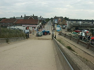
Berney Arms is a remote settlement on the north bank of the River Yare, close to Breydon Water in the English county of Norfolk. It is part of the civil parish of Reedham, is in the district of Broadland and lies within The Broads. It comprises a railway station, a windmill, a farmhouse and a pub which closed in late 2015. As of 2020, an adjacent property has opened as a bistro. The area is not accessible by public road.
The Norfolk Windmills Trust is a charity based in Norfolk, England, which restores and cares for windmills in that county.
The River Ant is a tributary river of the River Bure in the county of Norfolk, England. It is 27 kilometres (17 mi) long, and has an overall drop of 27 metres from source to mouth. It is said that the Ant was formerly known as the River Smale and that this is the origin of the name of the village of Smallburgh.

The River Thurne is a river in Norfolk, England in The Broads. Just 7 miles (11 km) long, it rises 2 miles (3.2 km) from the coast near Martham Broad and is navigable from West Somerton. It flows southwest and is linked by Candle Dyke and Heigham Sound to both Horsey Mere and Hickling Broad. It continues southwest and flows through Potter Heigham and enters the River Bure just south of Thurne dyke, near St Benet's Abbey.
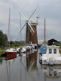
Horsey Windpump is a windpump or drainage windmill in the care of the National Trust in the village of Horsey, on The Broads near Great Yarmouth, Norfolk, England. The structure is a grade II* listed building.

Lockgate Mill also referred to locally and historically as Freethorpe Mill, 'Banham's Black Mill' and 'Duffel's Mill' is a windpump located on the Halvergate Marshes in the detached parish of Freethorpe within The Broads in the English county of Norfolk. It is approximately 2 miles (3.2 km) west of Great Yarmouth, and 3 miles (4.8 km) north-east of Berney Arms on the northern edge of Breydon Water. The structure is a Grade II listed building.
Lambridge Mill also known as Lambrigg Mill is a wind pump located in the parish of Sea Palling within the Norfolk Broads National Park, United Kingdom and can be found at grid reference grid reference TG431252, it is approximately 2 miles southwest of Waxham. The wind pump is a grade II listed building.
Sir Berney Brograve, 1st Baronet was the eldest son and heir of Thomas Brograve (1691–1753) of Great Baddow, Essex, and his wife Juliana Berney. He was a descendant of Sir John Brograve, Attorney-General to the Duchy of Lancaster. Juliana Berney was descended from Sir Richard Berney, 1st Baronet of Parkhall.
Sir George Berney Brograve, 2nd Baronet. Brograve was a Lieutenant Colonel in the Norfolk Militia and High Sheriff of Norfolk in 1802. He lived at Worstead House near Worstead in Norfolk.

Waxham is a small village in Norfolk in eastern England. It lies on the north-east coast of the county in Sea Palling parish. Buildings in the village include Waxham Hall, the 14th-century St. John's Church and the 16th-century Waxham Great Barn. Waxham Hall is reputedly haunted by the ghosts of six members of the Brograve family, all of whom died in battle. It is said that an 18th-century owner of the house once invited them all to dinner. Waxham Great Barn built about 1570, at 178 feet long is one of the largest barns of its age in the country. It has recently been restored and opened to the public. The village has an extensive beach backed by dunes. Many migrant birds pass through the area in spring and autumn and common cranes feed in fields near the village.
Sea Palling is a village and a civil parish covering 11.05 km2 (4.27 sq mi) in the English county of Norfolk. The village is 19.6 miles (31.5 km) south-east of Cromer, 19.6 miles (31.5 km) north-east of Norwich and 140 miles (230 km) north-east of London. The village lies 4 mi (6.4 km) east of the A149 between Kings Lynn and Great Yarmouth. The nearest railway station is at North Walsham for the Bittern Line which runs between Sheringham, Cromer and Norwich.

Hickling is a village and a civil parish in the English county of Norfolk. The village is 22 miles south-east of Cromer, 20.3 miles north-east of Norwich and 137 miles north-east of London. The village lies 3 miles east of the Broadlands town of Stalham. The nearest railway station is at Worstead for the Bittern Line which runs between Sheringham, Cromer and Norwich.

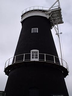
Berney Arms Windmill is a tower mill located at Berney Arms alongside the River Yare at the south-western end of Breydon Water in the English county of Norfolk. The windmill is in an isolated spot in The Broads around 3.5 miles (5.6 km) north-east of the village of Reedham and 4 miles (6.4 km) south-west of Great Yarmouth. The mill has no road access but can be accessed by boat, by foot or from Berney Arms railway station. It is a Scheduled Ancient Monument under the care of English Heritage.

Hunsett Mill is located on the east bank of the River Ant one mile north of Barton Broad in the English county of Norfolk. The Windmill is 1.2 miles south west of the town of Stalham. The mill structure is a grade II listed building.

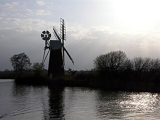
Boardman's Drainage Windmill is located at How Hill in the English county of Norfolk It is on the east bank of the River Ant close to the large Edwardian building houses the Norfolk Broads Study Centre. The Drainage mill is 1+1⁄2 miles (2.4 km) west of the village of Ludham. The structure is a grade II* listed building.
Horsey is a village and civil parish in the English county of Norfolk within The Broads national park. It covers an area of 8.49 km2 (3.28 sq mi) and had a population of 99 in 40 households at the 2001 census. At the 2011 Census the population remained less than 100 and was included in the civil parish of Sea Palling. For the purposes of local government, it falls within the district of North Norfolk.

Starston Wind Pump is a hollow post mill for pumping water, situated west of the village of Starston in Norfolk, England. The Pump is 330 yards away from the parish church of Saint Margaret in Mill Field. The windpump is a Grade II listed building and a scheduled ancient monument. After some years on the Heritage at Risk Register because of its poor condition, it was restored in 2010.

Stubb Drainage Windmill is 1.9 miles east of Hickling in the English county of Norfolk. The Windmill is a Grade II listed building and was given this status on 30 September 1987. The estimate is that there were once about 200 wind powered drainage windmills in the Broadlands. Stubb Drainage windmill is listed as one that is at risk of decay by Norfolk County Council.


