The Broads is a network of mostly navigable rivers and lakes in the English counties of Norfolk and Suffolk. Although the terms "Norfolk Broads" and "Suffolk Broads" are correctly used to identify specific areas within the two counties respectively, the whole area is frequently referred to as the Norfolk Broads.

The River Waveney is a river which forms the boundary between Suffolk and Norfolk, England, for much of its length within The Broads. The earliest attestation of the name is from 1275, Wahenhe, from *wagen + ea, meaning the river by a quagmire.

Reedham is a village and civil parish in the English county of Norfolk and within The Broads. It is on the north bank of the River Yare, 12 miles (19 km) east of the city of Norwich, 7.5 mi (12.1 km) south-west of the town of Great Yarmouth and the same distance north-west of the Suffolk town of Lowestoft. The village's name means 'reedy homestead/village' or 'reedy hemmed-in land'.

The Halvergate Marshes are an area of grazing marsh in the east of the English county of Norfolk. They form part of the area of The Broads and lie between the River Bure and the River Yare, bordering Breydon Water on the east. The marshes cover an area of around 2,642 hectares An area of 1,432.7-hectare (3,540-acre) is a biological Site of Special Scientific Interest. Some areas are also in the Breydon Water Local Nature Reserve, the Broadland and Breydon Water Ramsar sites, The Broads Special Area of Conservation, and The Broads and Breydon Water Special Protection Areas.

Berney Arms is a settlement on the north bank of the River Yare, close to Breydon Water in the English county of Norfolk. It is part of the civil parish of Reedham, in the district of Broadland, and lies within The Broads. It comprises a railway station, a windmill, a farmhouse and a pub which closed in late 2015. In 2020, an adjacent property opened as a bistro. The area is not accessible by public road.

Halvergate is a village and civil parish in the English county of Norfolk, north of Reedham, between the Rivers Bure and Yare, within The Broads. To the east of the village is the hamlet of Wickhampton and the Halvergate Marshes, an area of drainage marsh which was the site of the first Environmentally Sensitive Area in the United Kingdom in 1987.

The Haddiscoe Cut or New Cut is a canal in the English county of Norfolk and in The Broads National Park.). The cut was conceived as a way to provide a more direct route from Lowestoft to Norwich, and was built as part of a larger scheme which included the linking of the River Waveney to Oulton Broad and Lake Lothing. It was opened in 1833, but the new route was not a financial success, and it was sold to a railway developer in 1842. It remained in railway ownership until Nationalisation in 1948, and was damaged by floods in 1953. An attempt to close it in 1954 was resisted by local interests, resulting in it being repaired. It is now managed by the Environment Agency.

The River Yare is a river in the English county of Norfolk. In its lower reaches it is one of the principal navigable waterways of The Broads and connects with the rest of the network.

The River Chet is a small river in South Norfolk, England, a tributary of the River Yare. It rises in Poringland and flows eastwards through Alpington, Bergh Apton, Thurton and Loddon. At Loddon it passes under the A146 through Loddon Mill and into Loddon Staithe. From this point onwards the river is navigable. It then passes Hardley Flood to the north, a nature reserve part-managed by the Norfolk Wildlife Trust. The river finally joins the River Yare one mile west of Reedham at Hardley Cross, erected in 1676, which marks the ancient boundary between the City of Norwich and the Borough of Great Yarmouth. The total navigable length is some 3½ miles.

The River Wensum is a chalk river in Norfolk, England and a tributary of the River Yare, despite being the larger of the two rivers. The river is a biological Site of Special Scientific Interest and Special Area of Conservation.

The River Wissey is a river in Norfolk, eastern England. It rises near Bradenham, and flows for nearly 31 miles (50 km) to join the River Great Ouse at Fordham. The lower 11.2 miles (18.0 km) are navigable. The upper reaches are notable for a number of buildings of historic interest, which are close to the banks. The river passes through the parkland of the Arts and Crafts Pickenham Hall, and further downstream, flows through the Army's Stanford Training Area (STANTA), which was created in 1942 by evacuating six villages. The water provided power for at least two mills, at Hilborough and Northwold. At Whittington, the river becomes navigable, and is surrounded by fenland. A number of pumping stations pump water from drainage ditches into the higher river channel.

Berney Arms railway station is a stop on the Wherry Lines in the East of England, serving the settlement of Berney Arms on the Halvergate Marshes in Norfolk. It is located 15 miles 71 chains (25.6 km) east of Norwich and is the only station on a short stretch of single line between Reedham and Great Yarmouth. The station is managed by Greater Anglia, which also operates all trains serving it.

Wherryman's Way is a long-distance footpath in the English county of Norfolk.

Reedham Ferry is a vehicular chain ferry across the River Yare in the English county of Norfolk, in the Broads. The ferry crosses the river near the village of Reedham and is the only crossing of the Yare between the bridge carrying the A47 on the eastern outskirts of Norwich and Great Yarmouth, saving users a journey of over 30 miles. The ferry is also the only remaining vehicle ferry in Norfolk. The current ferryboat was built in 1983 and can carry three cars at a time. Reedham Ferry is also the name of an inn standing adjacent to the ferry on the northern bank.

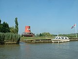
Berney Arms Windmill is a tower mill located at Berney Arms alongside the River Yare at the south-western end of Breydon Water in the English county of Norfolk. The windmill is in an isolated spot in The Broads around 3.5 miles (5.6 km) north-east of the village of Reedham and 4 miles (6.4 km) south-west of Great Yarmouth. The mill has no road access but can be accessed by boat, by foot or from Berney Arms railway station. It is a scheduled monument under the care of English Heritage.
North Mill is the name of a number of mills.
Reedham Swing Bridge, on the site of a Victorian swing bridge, is still in use at Reedham, Norfolk, England.

Limpenhoe Meadows is a 12-hectare (30-acre) biological Site of Special Scientific Interest west of Reedham in Norfolk. It is part of the Broadland Ramsar site and Special Protection Area, and The Broads Special Area of Conservation.

Limpenhoe is a village and former civil parish, now in the Cantley, Limpenhoe and Southwood, in the Broadland district, in the county of Norfolk, England. It is located on the north bank of the River Yare, between the villages of Cantley and Reedham, 8.2 miles (13.2 km) south-west of Great Yarmouth and 10.8 miles (17.4 km) south-east of Norwich. In 1931 the parish had a population of 156.