Woodlawn Heights, also known as Woodlawn, is a predominantly Irish-American working class neighborhood at the very north end of the borough of the Bronx in New York City. It is bounded by McLean Avenue to the north, the Bronx River to the east, Woodlawn Cemetery to the south, and Van Cortlandt Park to the west. Woodlawn Heights remains one of the few areas in New York City that still has young Irish immigrants still arriving to the area en masse.
Baychester is a neighborhood geographically located in the northeast part of the Bronx, New York City. Its boundaries are East 222nd Street to the northeast, the New England Thruway (I-95) to the east, Gun Hill Road to the southwest, and Boston Road to the northwest. Eastchester Road is the primary thoroughfare through Baychester.
Allerton is a working-class neighborhood geographically located in the East Bronx section of the Bronx, New York City. It is named in honor of Daniel Allerton, an early Bronx settler who purchased and farmed this area with his wife Hustace. It consists of two subsections called Bronxwood and Laconia. Its boundaries, starting from the north and moving clockwise, are Adee Avenue, Boston Road, and Gun Hill Road to the northeast; the IRT Dyre Avenue Line to the east; Waring Avenue to the south; and Bronx River Parkway to the west. White Plains Road and Boston Road are the primary thoroughfares through Allerton.

Williamsbridge is a neighborhood geographically located in the north-central portion of the Bronx in New York City. Its boundaries, starting from the north and moving clockwise are East 222nd Street to the north, Boston Road to the east, East Gun Hill Road to the south, and the Bronx River to the west. White Plains Road is the primary thoroughfare through Williamsbridge.

Country Club is a residential neighborhood located in the East Bronx in New York City. The neighborhood's boundaries are Middletown Road and Watt Avenue to the north, Eastchester Bay to the east, Layton Avenue and the Throggs Neck neighborhood to the south, and the New England Thruway and Pelham Bay neighborhood to the west. Pelham Bay Park, the largest public park in New York City, is located just north of Country Club.
East Tremont is a residential neighborhood located in the West Bronx, New York City. From the north and moving clockwise, it is bounded by East 180th Street, Southern Boulevard, the Cross-Bronx Expressway and Third Avenue. East Tremont Avenue is the primary thoroughfare through the neighborhood.

Bronx Community Board 1 is a local government unit of the city of New York, encompassing the neighborhoods of Mott Haven, Melrose, and Port Morris in the borough of the Bronx. It is delimited by the East River, East 149th Street, and Prospect Avenue on the east, East 161st Street, East 159th Street, and East 149th Street on the north, and the Harlem River and Bronx Kill on the west and south.

Bronx Community Board 2 is a local government unit of the city of New York, encompassing the neighborhoods of Hunts Point and Longwood in the borough of the Bronx. It is delimited by the Bronx River on the east, Westchester Avenue, East 167th Street, and East 169th Street on the north, Prospect Avenue and East 149th Street to the west, and the East River on the south.

University Heights is a neighborhood of the West Bronx in New York City. Its boundaries, starting from the north and moving clockwise, are: West Fordham Road to the north, Jerome Avenue to the east, West Burnside Avenue to the south and the Harlem River to the west. University Avenue is the primary thoroughfare in University Heights.

Bronx Community Board 3 is a local government unit in the New York City borough, of the Bronx, encompassing the neighborhoods of Crotona Park East, Claremont, Concourse Village, Melrose, and Morrisania. It is delimited by Sheridan Boulevard to the east, the Cross Bronx Expressway and Crotona Park North to the north, Park Avenue and Webster Avenue to the west, and East 159th Street and East 161st Street to the south.

Bronx Community Board 5 is a local government unit of the city of New York, encompassing the neighborhoods of Fordham, Morris Heights, Mount Hope, and University Heights. It is delimited by Webster Avenue to the east, Hall of Fame Terrace, West 183rd Street, and Fordham Road to the north, the Harlem River to the west, and Washington Bridge and the Cross Bronx Expressway to the south.

Bronx Community Board 6 is a local government unit of the city of New York, encompassing the neighborhoods of Bathgate, Belmont, East Tremont, and West Farms as Bronx Community District 6. It is delimited by Bronx Park to the east and north, Webster Avenue to the west, and Crotona Park North and the Cross Bronx Expressway to the south.

Bronx Community Board 7 the governing body of Bronx Community District 7, a local government unit of the city of New York. The Community District encompasses the neighborhoods of Bedford Park, Fordham, Jerome Park, Kingsbridge Heights, Norwood, and University Heights. It is delimited by the New York-New Haven Railroad, Webster Avenue, East Fordham Road, Jerome Avenue, and West 183rd Street to the east, Jerome Avenue, West Gun Hill Road, Goulden Avenue, Kingsbridge Road, West 225th Street, and the Harlem River to the west, West Gun Hill Road, Jerome Avenue, Bainbridge Avenue, and East 211th Street to the north and Hall of Fame Terrace to the south.
Bronx Community Board 9 is a local government unit of the city of New York, encompassing the neighborhoods of Castle Hill, Parkchester, Soundview, Harding Park, Bronx River, Clason Point and Unionport. It is delimited by Westchester Creek to the east, Sheridan Boulevard to the west, the Cross Bronx Expressway and East Tremont Avenue to the north and the Bronx River and the East River to the south.

Bronx Community Board 10 is a local government unit of the New York City borough of the Bronx, encompassing the neighborhoods of City Island, Co-op City, Pelham Bay, Throggs Neck and Westchester Square. It is delimited by the Hutchinson River and Pelham Bay Park to the east, New England Thruway, Hutchinson River Parkway, and Westchester Creek to the west, the Bronx/Westchester County Line to the north and the East River to the south.

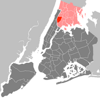
Bronx Community Board 12 is a local government unit of the New York City borough of the Bronx, encompassing the neighborhoods of Edenwald, Wakefield, Williamsbridge, Woodlawn Heights, Fish Bay, Eastchester, Olinville and Baychester.

Bronx Community Board 11 (CB11) is a small unit of the City of New York (NYC), whose district encompasses the neighborhoods of Allerton, Indian Village, Morris Park, Pelham Gardens, Pelham Parkway (neighborhood), Van Nest and other areas in the borough of the Bronx. Coterminous with the 49th NYPD Precinct, its district is delimited by Bronx Park East and the Bronx River Parkway to the west, Adee Avenue, Boston Road and East Gun Hill Road to the north, the Hutchinson River Parkway to the east, and East Tremont Avenue to the south.

Community boards of Manhattan are New York City community boards in the borough of Manhattan, which are the appointed advisory groups of the community districts that advise on land use and zoning, participate in the city budget process, and address service delivery in their district.
The Queens Community Board 7 is a local governmental advisory board in New York City, encompassing the neighborhoods of Flushing, Bay Terrace, College Point, Whitestone, Malba, Murray Hill, Linden Hill, Beechhurst, Queensboro Hill and Willets Point, in the borough of Queens. It is delimited by the Flushing Bay to the west, the East River to the north, Utopia Parkway and Little Neck Bay on the east, and Reeves Avenue on the south. CB7 is the biggest community board in Queens.
Community boards of the Bronx are the 12 New York City community boards in the borough of the Bronx, which are the appointed advisory groups of the community districts that advise on land use and zoning, participate in the city budget process, and address service delivery in their district.