Woodlawn Heights, Bronx

Last updated
Woodlawn Heights
Woodlawn Heights, The Bronx IMG 6711 HLG.jpg
"Welcome to Woodlawn Heights" sign.
Nickname: 
"Little Ireland"
Woodlawn Heights, Bronx
Location in New York City
Coordinates: 40°53′53″N73°52′01″W / 40.898°N 73.867°W / 40.898; -73.867
Country Flag of the United States.svg  United States
State Flag of New York.svg  New York
City Flag of New York City.svg New York City
Borough Flag of Bronx County, New York.svg The Bronx
Community District Bronx 12 [1]
Area
[2]
  Total0.62 km2 (0.240 sq mi)
Population
 (2010) [3]
  Total42,483
  Density68,000/km2 (180,000/sq mi)
Economics
   Median income $52,510
ZIP Codes
10470
Area code 718, 347, 929, and 917
Website woodlawn.nyc

Woodlawn Heights, also known as Woodlawn, is a predominantly Irish-American working class neighborhood at the very north end of the borough of the Bronx in New York City. [4] It is bounded by McLean Avenue to the north (slightly north of New York City's border with the city of Yonkers in Westchester County), the Bronx River to the east, Woodlawn Cemetery to the south, and Van Cortlandt Park to the west. Woodlawn Heights remains one of the few areas in New York City that still has young Irish immigrants still arriving to the area en masse.

Contents

Woodlawn Heights is part of Bronx Community Board 12, and its ZIP Code is 10470. [1] [5]

Major streets

Location of Woodlawn in the Bronx WoodlawnBronxNYC.JPG
Location of Woodlawn in the Bronx

Katonah Avenue, which runs north-south through the heart of Woodlawn Heights, is a popular destination for its many Irish pubs and restaurants. In addition, there is The Emerald Isle Immigration Center, an Italian bakery, an Italian restaurant, an Irish butcher shop, Irish and Albanian barber shops, and many other types of specialty shops. [6]

McLean Avenue, which runs east-west, is the main shopping strip for both Woodlawn Heights and the Yonkers neighborhood of McLean Heights. Its pubs and shops are considered to be some of the neighborhood's most notable fixtures, although technically it is within the city of Yonkers. McLean Avenue has many Irish pubs, a large variety of Irish and non-Irish restaurants and diners, two Irish gift shops, The Aisling Irish Community Center, an Irish butcher shop, and Italian pastry shop.

East 233rd Street is a major thoroughfare that runs east-west on the southern border of the neighborhood. It is largely known for its gas stations and Irish pubs, as well as for its bus routes and the Woodlawn station of the Metro-North Railroad. [7]

Notable features of the neighborhood include Oneida Triangle, a memorial to residents of Woodlawn Heights who served in World War I, [8] and Muskrat Cove, the northernmost segment of the Bronx River Greenway. [9]

Demographics

Based on data from the 2010 United States Census, the population of Woodlawn-Wakefield was 42,483, a decrease of 1,100 (2.5%) from the 43,583 counted in 2000. Covering an area of 901.76 acres (364.93 ha), the neighborhood had a population density of 47.1 inhabitants per acre (30,100/sq mi; 11,600/km2). [3] The racial makeup of the neighborhood was 17.6% (7,473) White, 58.3% (24,774) African American, 0.4% (169) Native American, 3.4% (1,465) Asian, 0.0% (20) Pacific Islander, 2.0% (855) from other races, and 2.0% (866) from two or more races. Hispanic or Latino of any race were 16.1% (6,861) of the population. [10]

Historically a German neighborhood, Woodlawn Heights is now a mostly Irish American neighborhood, which also has a small but recognizable Italian-American community. This neighborhood remains one of the few communities to which young and newly arrived Irish immigrants regularly arrive en masse. [7] [11] The Emerald Isle Immigration Center on Katonah Avenue and the Aisling Irish Community Center on McLean Avenue are two sources for the newly arrived as well as established Irish immigrants to Woodlawn Heights and the United States. The neighborhood is sometimes informally referred to as "Little Ireland". [12]

The entirety of Community District 12, which comprises Williamsbridge, Woodlawn Heights, Baychester, and Eastchester, had 156,542 inhabitants as of NYC Health's 2018 Community Health Profile, with an average life expectancy of 81.0 years. [13] :2,20 This is about the same as the median life expectancy of 81.2 for all New York City neighborhoods. [14] :53 (PDF p. 84) [15] Most inhabitants are youth and middle-aged adults: 24% are between the ages of between 0–17, 27% between 25–44, and 26% between 45–64. The ratio of college-aged and elderly residents was lower, at 10% and 13% respectively. [13] :2

As of 2017, the median household income in Community District 12 was $48,018. [16] In 2018, an estimated 22% of Woodlawn Heights and Williamsbridge residents lived in poverty, compared to 25% in all of the Bronx and 20% in all of New York City. One in eight residents (13%) were unemployed, compared to 13% in the Bronx and 9% in New York City. Rent burden, or the percentage of residents who have difficulty paying their rent, is 57% in Woodlawn Heights and Williamsbridge, compared to the boroughwide and citywide rates of 58% and 51% respectively. Based on this calculation, as of 2018, Woodlawn Heights and Williamsbridge are considered high-income relative to the rest of the city and not gentrifying. [13] :7

Police and crime

Woodlawn Heights and Williamsbridge are patrolled by the 47th Precinct of the NYPD, located at 4111 Laconia Avenue. [17] The 47th Precinct ranked 35th safest out of 69 patrol areas for per-capita crime in 2010. [18] As of 2018, with a non-fatal assault rate of 82 per 100,000 people, Woodlawn Heights and Williamsbridge's rate of violent crimes per capita is more than that of the city as a whole. The incarceration rate of 577 per 100,000 people is higher than that of the city as a whole. [13] :8

The 47th Precinct has a lower crime rate than in the 1990s, with crimes across all categories having decreased by 60.9% between 1990 and 2022. The precinct reported 16 murders, 45 rapes, 461 robberies, 732 felony assaults, 300 burglaries, 758 grand larcenies, and 461 grand larcenies auto in 2022. [19]

Fire safety

Woodlawn Heights is served by the New York City Fire Department (FDNY)'s Engine Co. 63/Ladder Co. 39/Battalion 15, located at 755 East 233rd Street. [20] [21]

Health

As of 2018, preterm births and births to teenage mothers are more common in Woodlawn Heights and Williamsbridge than in other places citywide. In Woodlawn Heights and Williamsbridge, there were 102 preterm births per 1,000 live births (compared to 87 per 1,000 citywide), and 24 births to teenage mothers per 1,000 live births (compared to 19.3 per 1,000 citywide). [13] :11 Woodlawn Heights and Williamsbridge has a low population of residents who are uninsured. In 2018, this population of uninsured residents was estimated to be 8%, lower than the citywide rate of 12%. [13] :14

The concentration of fine particulate matter, the deadliest type of air pollutant, in Woodlawn Heights and Williamsbridge is 0.0075 milligrams per cubic metre (7.5×10⁻⁹ oz/cu ft), the same as the city average. [13] :9 Eleven percent of Woodlawn Heights and Williamsbridge residents are smokers, which is lower than the city average of 14% of residents being smokers. [13] :13 In Woodlawn Heights and Williamsbridge, 30% of residents are obese, 14% are diabetic, and 39% have high blood pressure—compared to the citywide averages of 24%, 11%, and 28% respectively. [13] :16 In addition, 24% of children are obese, compared to the citywide average of 20%. [13] :12

Eighty-eight percent of residents eat some fruits and vegetables every day, which is about the same as the city's average of 87%. In 2018, 78% of residents described their health as "good", "very good", or "excellent", equal to the city's average of 78%. [13] :13 For every supermarket in Woodlawn Heights and Williamsbridge, there are 8 bodegas. [13] :10

The nearest large hospitals are Montefiore Medical Center and North Central Bronx Hospital, both located in Norwood. In addition, Montefiore Medical Center's Wakefield Campus is located in Williamsbridge. [22]

Post office and ZIP Code

Woodlawn Heights is located within the ZIP Code 10470. [23] The United States Postal Service operates the Woodlawn Station at 4364 Katonah Avenue. [24]

Education

Woodlawn Heights and Williamsbridge generally have a lower rate of college-educated residents than the rest of the city as of 2018. While 32% of residents age 25 and older have a college education or higher, 20% have less than a high school education and 48% are high school graduates or have some college education. By contrast, 26% of Bronx residents and 43% of city residents have a college education or higher. [13] :6 The percentage of Woodlawn Heights and Williamsbridge students excelling in math rose from 32% in 2000 to 48% in 2011, though reading achievement remained constant at 37% during the same time period. [25]

Woodlawn Heights and Williamsbridge's rate of elementary school student absenteeism is slightly higher than the rest of New York City. In Woodlawn Heights and Williamsbridge, 29% of elementary school students missed twenty or more days per school year, more than the citywide average of 20%. [14] :24 (PDF p. 55) [13] :6 Additionally, 70% of high school students in Woodlawn Heights and Williamsbridge graduate on time, about the same as the citywide average of 75%. [13] :6

Schools

PS 19, Katonah Avenue Weiss Woodlawn School PS 19 jeh.jpg
PS 19, Katonah Avenue

The St. Barnabas parish runs St. Barnabas Elementary School, [26] which opened in 1914 (whose principal is currently Miranda Marques). St. Barnabas High School, an all-girls school which opened in 1928 is run by principal Henry Triana. The high school has since been independent from the parish as of September 2015. [27] In addition to the aforementioned St. Barnabas parish schools, the neighborhood is served by Judith K. Weiss School P.S. 19. [28]

Library

The New York Public Library (NYPL)'s Woodlawn Heights branch is located at 4355 Katonah Avenue. The branch opened in 1931 and moved to its current one-story, 2,500-square-foot (230 m2) location in 1969. The Woodlawn Heights branch contains an extensive collection of Irish books. [29]

Community and civic organizations

Muskrat Cove, a local park between the Woodlawn station and the southbound off-ramp from the Bronx River Parkway to East 233rd Street Woodlawn Metro-North Station; Muskrat Cove.JPG
Muskrat Cove, a local park between the Woodlawn station and the southbound off-ramp from the Bronx River Parkway to East 233rd Street

Woodlawn has numerous community and civic organizations.

Places of worship

The Roman Catholic church of St. Barnabas is the largest church in Woodlawn Heights and part of St. Barnabas parish. The parish is managed by Reverend Brendan A. Fitzgerald. The parish has weekly masses in English and Italian and some seasonal holiday masses in Irish. St. Barnabas Parish, founded in 1910, serves as a major community center for the neighborhood, which is nearly entirely Catholic, and a center of Irish culture, offering Irish language classes and an Irish Outreach program to assist Irish immigrants in finding jobs and residence in the neighborhood. In addition to the church, the parish runs an adjoining convent (currently occupied by the large and growing community of the Sisters of Life) and St. Barnabas Elementary School. [27]

St. Mark's Lutheran Church Mark EV Lutheran Church Kimball Av jeh.jpg
St. Mark's Lutheran Church

St. Mark's Lutheran Church is on Saint Marks Place in Yonkers near the Van Cortlandt Park entrance.

St. Stephen's Woodlawn St. Stephen Woodlawn hours sign.jpg
St. Stephen's Woodlawn

St. Stephen's Episcopal Church is located on E. 238th Street at the corner of Vireo Avenue. It is the oldest church in Woodlawn and a member of the world-wide Anglican Communion. [33]

Transportation

Woodlawn Heights is served by the Bx16 , Bx31 , Bx34 and BxM4 buses operated by MTA Regional Bus Operations; [34] by the Woodlawn station on the New York City Subway's 4 train; [35] and by the Woodlawn station on the Metro-North Railroad's Harlem Line. [36]

See also

Related Research Articles

<span class="mw-page-title-main">Pelham Bay (neighborhood), Bronx</span> Neighborhood of the Bronx in New York City

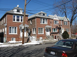
Pelham Bay is a middle class residential neighborhood in the borough of the Bronx, in New York City. It is named for Pelham Bay Park, New York City's largest park, which lies on the neighborhood's northeastern border; and for Pelham Bay, a body of water in that park. The neighborhood is bounded roughly by Pelham Parkway on the north, the New England Thruway (I-95) on the east, the Bruckner Expressway (I-95) on the south, and the Hutchinson River Parkway on the west.

Baychester is a neighborhood geographically located in the northeast part of the Bronx, New York City. Its boundaries are East 222nd Street to the northeast, the New England Thruway (I-95) to the east, Gun Hill Road to the southwest, and Boston Road to the northwest. Eastchester Road is the primary thoroughfare through Baychester.

Pelham Gardens is a neighborhood located in the Northeast section of the Bronx, New York City. Its boundaries, starting from the north and moving clockwise are East Gun Hill Road to the north and east, Pelham Parkway to the south, and the IRT Dyre Avenue Line to the west ending at the esplanade. Eastchester Road is the primary thoroughfare through Pelham Gardens.

<span class="mw-page-title-main">Wakefield, Bronx</span> Neighborhood of the Bronx in New York City

Wakefield is a working-class and middle-class section of the northern borough of the Bronx in New York City. It is bounded by the city's border with Westchester County to the north, East 222nd Street to the south, and the Bronx River Parkway to the west.

Allerton is a working-class neighborhood geographically located in the East Bronx section of the Bronx, New York City. It is named in honor of Daniel Allerton, an early Bronx settler who purchased and farmed this area with his wife Hustace. It consists of two subsections called Bronxwood and Laconia. Its boundaries, starting from the north and moving clockwise, are Adee Avenue, Boston Road, and Gun Hill Road to the northeast; the IRT Dyre Avenue Line to the east; Waring Avenue to the south; and Bronx River Parkway to the west. White Plains Road and Boston Road are the primary thoroughfares through Allerton.

<span class="mw-page-title-main">Fordham, Bronx</span> Neighborhood of the Bronx in New York City

Fordham Manor is a neighborhood located in the western Bronx, New York City. Fordham is roughly bordered by East 196th Street to the north, the Harlem River to the west, Fordham Road to the south, and Southern Boulevard to the east. The neighborhood's primary thoroughfares are Fordham Road and Grand Concourse.

<span class="mw-page-title-main">Tremont, Bronx</span> Neighborhood of the Bronx in New York City

Tremont is a residential neighborhood in the West Bronx, New York City. Its boundaries are East 181st Street to the north, Third Avenue to the east, the Cross-Bronx Expressway to the south, and the Grand Concourse to the west. East Tremont Avenue is the primary thoroughfare through Tremont.

<span class="mw-page-title-main">Melrose, Bronx</span> Neighborhood of the Bronx in New York City

Melrose is a mostly residential neighborhood in the southwestern section of the New York City borough of the Bronx. It adjoins the business and one-time theater area known as The Hub. Melrose is rectangular-shaped, being bordered by Saint Anns Avenue on the east, 149th Street on the south, Park Avenue on the west, and 163rd Street to the north. Melrose Avenue and Third Avenue are the primary thoroughfares through Melrose.

<span class="mw-page-title-main">Norwood, Bronx</span> Neighborhood of the Bronx in New York City

Norwood, also known as Bainbridge, is a residential neighborhood in the northwest Bronx, New York City, U.S. It is bound by Van Cortlandt Park and Woodlawn Cemetery to the north, the Bronx River to the east, and Mosholu Parkway to the southwest. The area is dominated topographically by what was once Valentine's Hill, the highest point being near the intersection of 210th Street and Bainbridge Avenue, where Gun Hill Road intersects, and around the Montefiore Medical Center, the largest landowner and employer of the neighborhood. Norwood's main commercial arteries are Gun Hill Road, Jerome Avenue, Webster Avenue, and Bainbridge Avenue.

<span class="mw-page-title-main">Williamsbridge, Bronx</span> Neighborhood of the Bronx in New York City

Williamsbridge is a neighborhood geographically located in the north-central portion of the Bronx in New York City. Its boundaries, starting from the north and moving clockwise are East 222nd Street to the north, Boston Road to the east, East Gun Hill Road to the south, and the Bronx River to the west. White Plains Road is the primary thoroughfare through Williamsbridge.

<span class="mw-page-title-main">Country Club, Bronx</span> Neighborhood of the Bronx in New York City

Country Club is a residential neighborhood located in the East Bronx in New York City. The neighborhood's boundaries are Middletown Road and Watt Avenue to the north, Eastchester Bay to the east, Layton Avenue and the Throggs Neck neighborhood to the south, and the New England Thruway and Pelham Bay neighborhood to the west. Pelham Bay Park, the largest public park in New York City, is located just north of Country Club.

<span class="mw-page-title-main">Bedford Park, Bronx</span> Neighborhood of the Bronx in New York City

Bedford Park is a residential neighborhood in the northwest Bronx, New York City, adjacent to the New York Botanical Garden. Its boundaries, starting from the north and moving clockwise, are: Mosholu Parkway to the north, Webster Avenue to the east, East 196th Street to the south, and Jerome Avenue to the west.

<span class="mw-page-title-main">East Tremont, Bronx</span> Neighborhood of the Bronx in New York City

East Tremont is a residential neighborhood located in the West Bronx, New York City. From the north and moving clockwise, it is bounded by East 180th Street, Southern Boulevard, the Cross-Bronx Expressway and Third Avenue. East Tremont Avenue is the primary thoroughfare through the neighborhood.

<span class="mw-page-title-main">Eastchester, Bronx</span> Neighborhood of the Bronx in New York City

Eastchester is a working-class neighborhood in the northeast Bronx in New York City. Its boundaries, starting from the north and moving clockwise are the Bronx-Westchester County border to the north, the New England Thruway to the east, Baychester Avenue to the south, and the intersection of 233rd Street and Baychester Avenue to the west. Boston Road is the primary thoroughfare through Eastchester and Dyre Avenue is the main commercial street. Eastchester includes the sub-neighborhood of Edenwald.

<span class="mw-page-title-main">University Heights, Bronx</span> Neighborhood of the Bronx in New York City

University Heights is a neighborhood of the West Bronx in New York City. Its boundaries, starting from the north and moving clockwise, are: West Fordham Road to the north, Jerome Avenue to the east, West Burnside Avenue to the south and the Harlem River to the west. University Avenue is the primary thoroughfare in University Heights.

<span class="mw-page-title-main">Morris Park, Bronx</span> Neighborhood of the Bronx in New York City

Morris Park is a neighborhood in the New York City borough of the Bronx. Its approximate boundaries, starting from the north and moving clockwise, are Neill Avenue and Pelham Parkway to the north, Eastchester Road to the east, the Amtrak Northeast Corridor tracks and Sackett Avenue to the east and south, and Bronxdale Avenue and White Plains Road to the west. It borders the neighborhoods of Van Nest to its southwest and Pelham Parkway to its northeast. Williamsbridge Road and Morris Park Avenue are the primary thoroughfares.

<span class="mw-page-title-main">Bronx Community Board 12</span> Community District in New York, United States

Bronx Community Board 12 is a local government unit of the New York City borough of the Bronx, encompassing the neighborhoods of Edenwald, Wakefield, Williamsbridge, Woodlawn Heights, Fish Bay, Eastchester, Olinville and Baychester.

<span class="mw-page-title-main">Morris Heights, Bronx</span> Neighborhood of the Bronx in New York City

Morris Heights is a residential neighborhood located in the West Bronx. Its boundaries, starting from the north and moving clockwise are: West Burnside Avenue to the north, Jerome Avenue to the east, the Cross-Bronx Expressway to the south, and the Harlem River to the west. University Avenue is the primary thoroughfare through Morris Heights.

<span class="mw-page-title-main">Pelham Parkway (neighborhood), Bronx</span> Neighborhood of the Bronx in New York City

Pelham Parkway is a working- and middle-class residential neighborhood geographically located in the center of the Bronx, a borough of New York City in the United States. Its boundaries, starting from the north and moving clockwise are: Waring Avenue to the north, the IRT Dyre Avenue Line tracks to the east, Neill Avenue to the South, and Bronx River Parkway to the west. White Plains Road is the primary commercial thoroughfare through Pelham Parkway. The neighborhood is named after Pelham Parkway, a major west–east parkway that travels through the East Bronx.

References

  1. 1 2 "NYC Planning | Community Profiles". communityprofiles.planning.nyc.gov. New York City Department of City Planning. Retrieved 25 February 2018.
  2. "Woodlawn neighborhood in New York" . Retrieved 6 October 2015.
  3. 1 2 Table PL-P5 NTA: Total Population and Persons Per Acre - New York City Neighborhood Tabulation Areas*, 2010, Population Division - New York City Department of City Planning, February 2012. Accessed June 16, 2016.
  4. "Woodlawn ranked among best family neighborhoods". News 12 The Bronx. Retrieved 2016-02-14.
  5. Cooper, Rebecca (March 14, 2003). "Neighborhoods: Close-Up on Woodlawn". Village Voice. Archived from the original on June 20, 2006.
  6. "Katonah Avenue". BridgeandTunnelClub.com. Photographs of Katonah Avenue
  7. 1 2 "If You're Thinking of Living In Woodlawn; A Bronx Enclave With a Suburban Feel". New York Times . February 16, 2003. Retrieved March 2, 2015.
  8. "Historical Signs: Oneida Triangle". nycgovparks.org.
  9. "New Bicycle Pathway Is Opened Along The Bronx River". June 4, 2008. Retrieved August 16, 2020.
  10. Table PL-P3A NTA: Total Population by Mutually Exclusive Race and Hispanic Origin - New York City Neighborhood Tabulation Areas*, 2010, Population Division - New York City Department of City Planning, March 29, 2011. Accessed June 14, 2016.
  11. "Woodlawn awaits return of hundreds of Irish students seeking 'a little Ireland'". NY Daily News. Retrieved October 6, 2015.
  12. Kugel, Seth (March 17, 2002). "NEIGHBORHOOD REPORT: WOODLAWN; There's the Irish Bar, and Then There's the Irish Bar". New York Times . Retrieved September 12, 2015.
  13. 1 2 3 4 5 6 7 8 9 10 11 12 13 14 15 "Williamsbridge and Baychester (Including Baychester, Eastchester, Edenwald, Olinville, Wakefield, Williamsbridge and Woodlawn)" (PDF). nyc.gov. NYC Health. 2018. Retrieved March 2, 2019.
  14. 1 2 "2016-2018 Community Health Assessment and Community Health Improvement Plan: Take Care New York 2020" (PDF). nyc.gov . New York City Department of Health and Mental Hygiene. 2016. Retrieved September 8, 2017.
  15. Short, Aaron (June 4, 2017). "New Yorkers are living longer, happier and healthier lives". New York Post. Retrieved March 1, 2019.
  16. "NYC-Bronx Community District 12--Wakefield, Williamsbridge & Woodlawn PUMA, NY" . Retrieved July 17, 2018.
  17. "NYPD – 47th Precinct". www.nyc.gov. New York City Police Department . Retrieved October 3, 2016.
  18. "Eastchester: Wakefield, Williamsbridge, Woodlawn – DNAinfo.com Crime and Safety Report". www.dnainfo.com. Archived from the original on April 15, 2017. Retrieved October 6, 2016.
  19. "47th Precinct CompStat Report" (PDF). www.nyc.gov. New York City Police Department . Retrieved July 22, 2018.
  20. "Engine Company 36/Ladder Company 39/Battalion 15". FDNYtrucks.com. Retrieved March 14, 2019.
  21. "FDNY Firehouse Listing – Location of Firehouses and companies". NYC Open Data; Socrata . New York City Fire Department. September 10, 2018. Retrieved March 14, 2019.
  22. "Best 30 Hospitals in Bronx, NY with Reviews". Yellow Pages. Retrieved March 14, 2019.
  23. "Wakefield-Williamsbridge, New York City-Bronx, New York Zip Code Boundary Map (NY)". United States Zip Code Boundary Map (USA). Retrieved March 18, 2019.
  24. "Location Details: Woodlawn". USPS.com. Retrieved March 7, 2019.
  25. "Williamsbridge / Baychester – BX 12" (PDF). Furman Center for Real Estate and Urban Policy. 2011. Retrieved October 5, 2016.
  26. St. Barnabas Elementary School
  27. 1 2 DosSantos, Juliann (April 30, 2015). "St. Barnabas High School to Become Independent". Catholic New York. New York. p. 12. Retrieved 2016-02-10.
  28. "PS 19". www.ps19.us. Retrieved 18 November 2017.
  29. "About the Woodlawn Heights Library". The New York Public Library. Retrieved March 14, 2019.
  30. "BRONX MALL - Bronx Community Board 12". www.bronxmall.com. Retrieved 18 November 2017.
  31. "Calendar - 47th Precinct Community Council - Bronx, NY 10466". www.neighborhoodlink.com.
  32. "Woodlawn Collective". Woodlawn Collective. Retrieved November 19, 2023.
  33. "St. Stephen's Church (Woodlawn), Bronx". Episcopal Diocese of New York. November 29, 2016. Retrieved November 19, 2023.
  34. "Bronx Bus Map" (PDF). Metropolitan Transportation Authority. October 2018. Retrieved December 1, 2020.
  35. "Subway Map" (PDF). Metropolitan Transportation Authority. September 2021. Retrieved September 17, 2021.
  36. "Harlem Line". Station Reporter.

Further reading